Sassandra elevation
Sassandra (Bas-Sassandra), Ivory Coast elevation is 38 meters and Sassandra elevation in feet is 125 ft above sea level [src 1]. Sassandra is a populated place (feature code) with elevation that is 191 meters (627 ft) smaller than average city elevation in Ivory Coast.
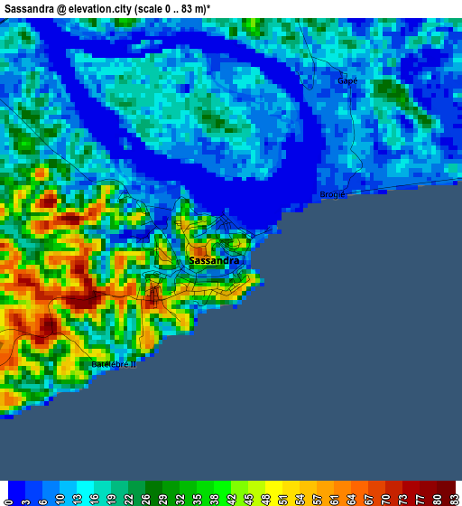
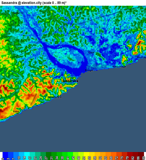
Below is the Elevation map of Sassandra, which displays elevation range with different colors. Scale of the first map is from 0 to 83 m (0 to 272 ft) with average elevation of 19.6 meters (=64 ft) [note 1]
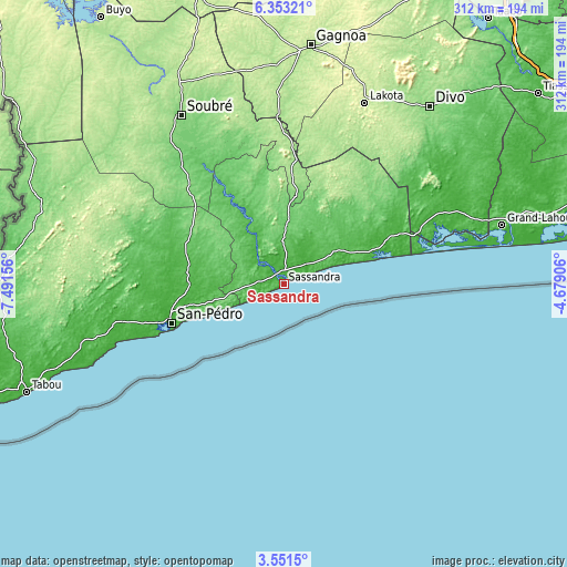
These maps also provides idea of topography and contour of this city, they are displayed at different zoom levels. More info about maps, scale and edge coordinates you can find below images.
| \ | Map #1 | Map #2 | Topo.Map |
| Scale [m] | 0..83 m | 0..89 m | × |
| Scale [ft] | 0..272 ft | 0..292 ft | × |
| Average | 19.6 m = 64 ft | 24.1 m = 79 ft | × |
| Width | 9.74 km = 6.1 mi | 19.47 km = 12.1 mi | 311.5 km = 193.6 mi |
| Height | 9.74 km = 6.1 mi | 19.47 km = 12.1 mi | 311.6 km = 193.6 mi |
| ↑Max Latitude | 4.99762° | 5.041396° | 6.35321° |
| Latitude at center | 4.95384° | 4.95384° | 4.95384° |
| ↓Min Latitude | 4.910057° | 4.866272° | 3.5515° |
| ← Min Longitude | -6.129255° | -6.173201° | -7.49156° |
| Longitude center | -6.08531° | -6.08531° | -6.08531° |
| →Max Longitude | -6.041365° | -5.997419° | -4.67906° |
Nearby cities:
Cities around Sassandra sort by population:
• San-Pédro elevation 9 m
65.2 km,  249°
249°
• Divo 147 m
127.1 km,  39°
39°
• Gagnoa 202 m
131.8 km,  6°
6°
• Lakota 228 m
108.9 km,  24°
24°
• Tiassalé 29 m
174.8 km,  53°
53°
• Tabou 9 m
152.4 km, 247°
• Guibéroua 230 m
143.2 km,  356°
356°
• Grand-Lahou 77 m
124.3 km,  74°
74°
• Guitry 41 m
112.7 km,  56°
56°
• Soubré 140 m
108.1 km,  328°
328°
• Guéyo 188 m
81.7 km,  1°
1°
• Fresco 69 m
58.9 km,  75°
75°
Multilingual:
 En español:
Sassandra elevación 38 m.
 En France:
Sassandra élévation 38 m.
 Auf Deutsch:
Sassandra höhe über dem Meeresspiegel ist 38 m.
 На русском:
Сассандра, Сасандра высота над уровнем моря 38 м
Sources and notes:
- [note 1] Map square and city borders are not equal. Map elevation data is calculated only from area inside that square.
- [src 1] Elevation data from geonames database provided with same terms of usage.
- [src 2] The elevation map of Sassandra is generated using elevation data from NASA's 3 arcsec (90m) resolution SRTM data.
- [src 3] Base (background) map © OpenStreetMap contributors tiles are generated by Geofabrik and OpenTopoMap.
Copyright & License:
This Sassandra Elevation Map is licensed under CC BY-SA. You may reuse any part from this page, if you give a proper credit by linking to this URL:
 More info on terms of use page.