Oberglatt / Bahnhofquartier elevation
Oberglatt / Bahnhofquartier (Zurich, Bezirk Dielsdorf), Switzerland elevation is 428 meters and Oberglatt / Bahnhofquartier elevation in feet is 1404 ft above sea level [src 1]. Oberglatt / Bahnhofquartier is a section of populated place (feature code) with elevation that is 120 meters (394 ft) smaller than average city elevation in Switzerland.
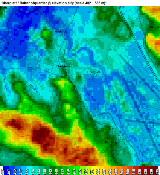
Below is the Elevation map of Oberglatt / Bahnhofquartier, which displays elevation range with different colors. Scale of the first map is from 402 to 535 m (1319 to 1755 ft) with average elevation of 439.4 meters (=1442 ft) [note 1]
These maps also provides idea of topography and contour of this city, they are displayed at different zoom levels. More info about maps, scale and edge coordinates you can find below images.
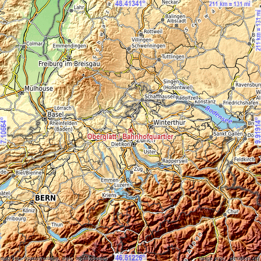
| \ | Map #1 | Topo.Map |
| Scale [m] | 402..535 m | × |
| Scale [ft] | 1319..1755 ft | × |
| Average | 439.4 m = 1442 ft | × |
| Width | 6.61 km = 4.1 mi | 211.4 km = 131.4 mi |
| Height | 6.61 km = 4.1 mi | 211.4 km = 131.4 mi |
| ↑Max Latitude | 47.501127° | 48.41341° |
| Latitude at center | 47.47143° | 47.47143° |
| ↓Min Latitude | 47.441716° | 46.51226° |
| ← Min Longitude | 8.468945° | 7.10664° |
| Longitude center | 8.51289° | 8.51289° |
| →Max Longitude | 8.556835° | 9.91914° |
Nearby cities:
Cities around Oberglatt / Bahnhofquartier sort by population:
• Rümlang elevation 448 m
2.7 km,  151°
151°
• Dielsdorf 435 m
4.2 km,  285°
285°
• Niederglatt 417 m
2.4 km,  335°
335°
• Oberglatt 430 m
0.7 km,  43°
43°
• Rümlang / Rümlang (Dorfkern) 445 m
2.9 km, 148°
• Bachenbülach 427 m
4.3 km,  34°
34°
• Niederhasli 421 m
2.3 km,  295°
295°
• Sonnhalde 446 m
4.4 km,  242°
242°
• Oberglatt / Oberglatt (Dorfkern) 430 m
0.7 km, 43°
• Niederglatt / Niederglatt (Dorfkern) 419 m
2.3 km, 336°
• Hofstetten 432 m
0.9 km,  325°
325°
• Höri 419 m
4.1 km,  359°
359°
Multilingual:
 En español:
Oberglatt / Bahnhofquartier elevación 428 m.
 En France:
Oberglatt / Bahnhofquartier élévation 428 m.
 Auf Deutsch:
Oberglatt / Bahnhofquartier höhe über dem Meeresspiegel ist 428 m.
 На русском:
Oberglatt / Bahnhofquartier высота над уровнем моря 428 м
Sources and notes:
- [note 1] Map square and city borders are not equal. Map elevation data is calculated only from area inside that square.
- [src 1] Elevation data from geonames database provided with same terms of usage.
- [src 2] The elevation map of Oberglatt / Bahnhofquartier is generated using elevation data from NASA's 3 arcsec (90m) resolution SRTM data.
- [src 3] Base (background) map © OpenStreetMap contributors tiles are generated by Geofabrik and OpenTopoMap.
Copyright & License:
This Oberglatt / Bahnhofquartier Elevation Map is licensed under CC BY-SA. You may reuse any part from this page, if you give a proper credit by linking to this URL:
 More info on terms of use page.