Höri elevation
Höri (Zurich, Bezirk Bülach), Switzerland elevation is 419 meters and Höri elevation in feet is 1375 ft above sea level [src 1]. Höri is a populated place (feature code) with elevation that is 129 meters (423 ft) smaller than average city elevation in Switzerland.
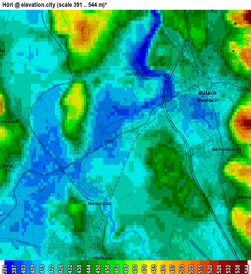
Below is the Elevation map of Höri, which displays elevation range with different colors. Scale of the first map is from 391 to 544 m (1283 to 1785 ft) with average elevation of 429.8 meters (=1410 ft) [note 1]
These maps also provides idea of topography and contour of this city, they are displayed at different zoom levels. More info about maps, scale and edge coordinates you can find below images.
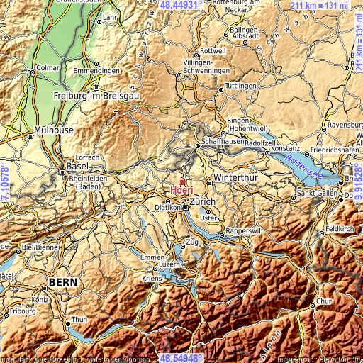
| \ | Map #1 | Topo.Map |
| Scale [m] | 391..544 m | × |
| Scale [ft] | 1283..1785 ft | × |
| Average | 429.8 m = 1410 ft | × |
| Width | 6.6 km = 4.1 mi | 211.2 km = 131.2 mi |
| Height | 6.6 km = 4.1 mi | 211.2 km = 131.2 mi |
| ↑Max Latitude | 47.537666° | 48.44931° |
| Latitude at center | 47.50799° | 47.50799° |
| ↓Min Latitude | 47.478297° | 46.54948° |
| ← Min Longitude | 8.468085° | 7.10578° |
| Longitude center | 8.51203° | 8.51203° |
| →Max Longitude | 8.555975° | 9.91828° |
Nearby cities:
Cities around Höri sort by population:
• Bülach elevation 419 m
2.6 km,  53°
53°
• Niederglatt 417 m
2.1 km,  205°
205°
• Oberglatt 430 m
3.6 km,  171°
171°
• Bachenbülach 427 m
2.6 km,  102°
102°
• Bülach / Seematt 424 m
2.8 km,  68°
68°
• Bülach / Gstückt 455 m
3.2 km,  58°
58°
• Hochfelden 401 m
1.6 km,  9°
9°
• Neerach 448 m
3.1 km,  276°
276°
• Bülach / Soligänter 430 m
3 km, 46°
• Oberglatt / Oberglatt (Dorfkern) 430 m
3.6 km, 171°
• Niederglatt / Niederglatt (Dorfkern) 419 m
2.1 km,  204°
204°
• Hofstetten 432 m
3.4 km,  187°
187°
Multilingual:
 En español:
Höri elevación 419 m.
 En France:
Höri élévation 419 m.


Sources and notes:
- [note 1] Map square and city borders are not equal. Map elevation data is calculated only from area inside that square.
- [src 1] Elevation data from geonames database provided with same terms of usage.
- [src 2] The elevation map of Höri is generated using elevation data from NASA's 3 arcsec (90m) resolution SRTM data.
- [src 3] Base (background) map © OpenStreetMap contributors tiles are generated by Geofabrik and OpenTopoMap.
Copyright & License:
This Höri Elevation Map is licensed under CC BY-SA. You may reuse any part from this page, if you give a proper credit by linking to this URL:
 More info on terms of use page.