Altendorf elevation
Altendorf (Schwyz, Bezirk March), Switzerland elevation is 414 meters and Altendorf elevation in feet is 1358 ft above sea level [src 1]. Altendorf is a seat of a third-order administrative division (feature code) with elevation that is 134 meters (440 ft) smaller than average city elevation in Switzerland.
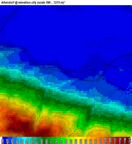
Below is the Elevation map of Altendorf, which displays elevation range with different colors. Scale of the first map is from 396 to 1215 m (1299 to 3986 ft) with average elevation of 558.8 meters (=1833 ft) [note 1]
These maps also provides idea of topography and contour of this city, they are displayed at different zoom levels. More info about maps, scale and edge coordinates you can find below images.
| \ | Map #1 | Map #2 | Topo.Map |
| Scale [m] | 396..1215 m | 396..1318 m | × |
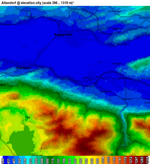
| Scale [ft] | 1299..3986 ft | 1299..4324 ft | × |
| Average | 558.8 m = 1833 ft | 634.5 m = 2082 ft | × |
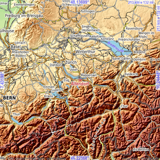
| Width | 6.64 km = 4.1 mi | 13.28 km = 8.3 mi | 212.5 km = 132 mi |
| Height | 6.64 km = 4.1 mi | 13.28 km = 8.3 mi | 212.5 km = 132 mi |
| ↑Max Latitude | 47.219796° | 47.249634° | 48.13699° |
| Latitude at center | 47.18994° | 47.18994° | 47.18994° |
| ↓Min Latitude | 47.160068° | 47.130179° | 46.22568° |
| ← Min Longitude | 8.794285° | 8.750339° | 7.43198° |
| Longitude center | 8.83823° | 8.83823° | 8.83823° |
| →Max Longitude | 8.882175° | 8.926121° | 10.24448° |
Nearby cities:
Cities around Altendorf sort by population:
• Rapperswil elevation 408 m
4.1 km,  343°
343°
• Jona 424 m
4.4 km,  0°
0°
• Freienbach 410 m
6.3 km,  285°
285°
• Rüti 470 m
7.5 km,  10°
10°
• Schübelbach 429 m
7 km,  105°
105°
• Pfäffikon 420 m
4.7 km, 285°
• Siebnen 447 m
4.8 km, 110°
• Lachen 413 m
1.2 km,  77°
77°
• Feusisberg 696 m
6.9 km,  267°
267°
• Rüti / Dorfzentrum, Südl. Teil 469 m
7.2 km, 11°
• Rüti / Westlicher Dorfteil 475 m
7.3 km, 3°
• Rüti / Oberdorf 540 m
7.9 km, 14°
Multilingual:
 En español:
Altendorf elevación 414 m.
 En France:
Altendorf élévation 414 m.
 Auf Deutsch:
Altendorf höhe über dem Meeresspiegel ist 414 m.

Sources and notes:
- [note 1] Map square and city borders are not equal. Map elevation data is calculated only from area inside that square.
- [src 1] Elevation data from geonames database provided with same terms of usage.
- [src 2] The elevation map of Altendorf is generated using elevation data from NASA's 3 arcsec (90m) resolution SRTM data.
- [src 3] Base (background) map © OpenStreetMap contributors tiles are generated by Geofabrik and OpenTopoMap.
Copyright & License:
This Altendorf Elevation Map is licensed under CC BY-SA. You may reuse any part from this page, if you give a proper credit by linking to this URL:
 More info on terms of use page.