Rüti / Dorfzentrum, Südl. Teil elevation
Rüti / Dorfzentrum, Südl. Teil (Zurich, Bezirk Hinwil), Switzerland elevation is 469 meters and Rüti / Dorfzentrum, Südl. Teil elevation in feet is 1539 ft above sea level [src 1]. Rüti / Dorfzentrum, Südl. Teil is a section of populated place (feature code) with elevation that is 79 meters (259 ft) smaller than average city elevation in Switzerland.
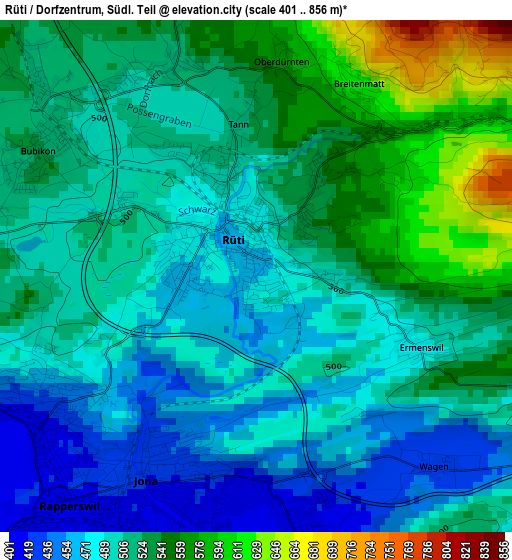
Below is the Elevation map of Rüti / Dorfzentrum, Südl. Teil, which displays elevation range with different colors. Scale of the first map is from 401 to 856 m (1316 to 2808 ft) with average elevation of 509.6 meters (=1672 ft) [note 1]
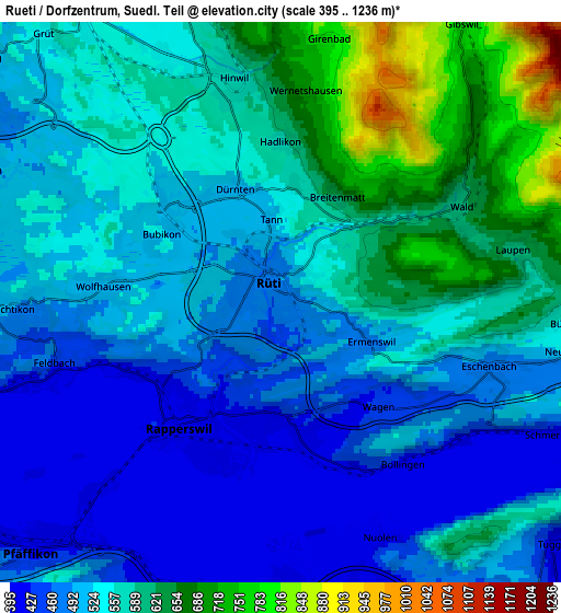
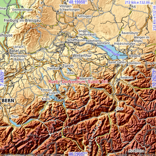
These maps also provides idea of topography and contour of this city, they are displayed at different zoom levels. More info about maps, scale and edge coordinates you can find below images.
| \ | Map #1 | Map #2 | Topo.Map |
| Scale [m] | 401..856 m | 395..1236 m | × |
| Scale [ft] | 1316..2808 ft | 1296..4055 ft | × |
| Average | 509.6 m = 1672 ft | 541.4 m = 1776 ft | × |
| Width | 6.63 km = 4.1 mi | 13.27 km = 8.2 mi | 212.3 km = 131.9 mi |
| Height | 6.63 km = 4.1 mi | 13.27 km = 8.2 mi | 212.2 km = 131.9 mi |
| ↑Max Latitude | 47.2835° | 47.313302° | 48.19958° |
| Latitude at center | 47.25368° | 47.25368° | 47.25368° |
| ↓Min Latitude | 47.223844° | 47.19399° | 46.29057° |
| ← Min Longitude | 8.812595° | 8.768649° | 7.45029° |
| Longitude center | 8.85654° | 8.85654° | 8.85654° |
| →Max Longitude | 8.900485° | 8.944431° | 10.26279° |
Nearby cities:
Cities around Rüti / Dorfzentrum, Südl. Teil sort by population:
• Rapperswil elevation 408 m
4.1 km,  219°
219°
• Jona 424 m
3 km,  206°
206°
• Rüti 470 m
0.3 km,  343°
343°
• Hinwil 573 m
4.6 km,  348°
348°
• Rüti / Westlicher Dorfteil 475 m
0.9 km,  282°
282°
• Tann 507 m
1.8 km, 344°
• Rüti / Oberdorf 540 m
0.9 km,  47°
47°
• Wolfhausen 505 m
4.3 km,  273°
273°
• Tann / Tann (Dorfkern) 503 m
1.3 km, 339°
• Bubikon 523 m
3.3 km,  296°
296°
• Hadlikon 591 m
3.8 km,  0°
0°
• Dürnten 514 m
3 km, 337°
Multilingual:
 En español:
Rüti / Dorfzentrum, Südl. Teil elevación 469 m.
 En France:
Rüti / Dorfzentrum, Südl. Teil élévation 469 m.
 Auf Deutsch:
Rüti / Dorfzentrum, Südl. Teil höhe über dem Meeresspiegel ist 469 m.
 На русском:
Rüti / Dorfzentrum, Südl. Teil высота над уровнем моря 469 м
Sources and notes:
- [note 1] Map square and city borders are not equal. Map elevation data is calculated only from area inside that square.
- [src 1] Elevation data from geonames database provided with same terms of usage.
- [src 2] The elevation map of Rüti / Dorfzentrum, Südl. Teil is generated using elevation data from NASA's 3 arcsec (90m) resolution SRTM data.
- [src 3] Base (background) map © OpenStreetMap contributors tiles are generated by Geofabrik and OpenTopoMap.
Copyright & License:
This Rüti / Dorfzentrum, Südl. Teil Elevation Map is licensed under CC BY-SA. You may reuse any part from this page, if you give a proper credit by linking to this URL:
 More info on terms of use page.