Andwil elevation
Andwil (Saint Gallen, Wahlkreis St. Gallen), Switzerland elevation is 711 meters and Andwil elevation in feet is 2333 ft above sea level [src 1]. Andwil is a populated place (feature code) with elevation that is 163 meters (535 ft) bigger than average city elevation in Switzerland.
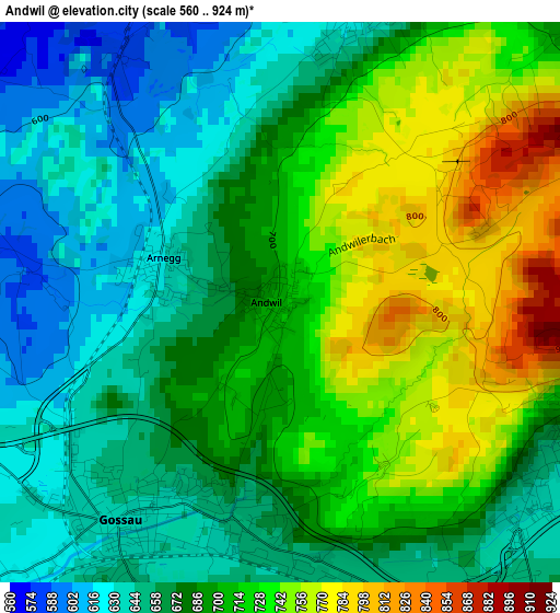
Below is the Elevation map of Andwil, which displays elevation range with different colors. Scale of the first map is from 560 to 924 m (1837 to 3031 ft) with average elevation of 691.3 meters (=2268 ft) [note 1]
These maps also provides idea of topography and contour of this city, they are displayed at different zoom levels. More info about maps, scale and edge coordinates you can find below images.
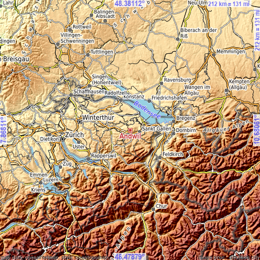
| \ | Map #1 | Topo.Map |
| Scale [m] | 560..924 m | × |
| Scale [ft] | 1837..3031 ft | × |
| Average | 691.3 m = 2268 ft | × |
| Width | 6.61 km = 4.1 mi | 211.5 km = 131.4 mi |
| Height | 6.61 km = 4.1 mi | 211.5 km = 131.4 mi |
| ↑Max Latitude | 47.468265° | 48.38112° |
| Latitude at center | 47.43855° | 47.43855° |
| ↓Min Latitude | 47.408818° | 46.47879° |
| ← Min Longitude | 9.230415° | 7.86811° |
| Longitude center | 9.27436° | 9.27436° |
| →Max Longitude | 9.318305° | 10.68061° |
Nearby cities:
Cities around Andwil sort by population:
• Sankt Gallen elevation 684 m
7.7 km,  102°
102°
• Gossau 637 m
3 km,  209°
209°
• Herisau 780 m
5.8 km,  176°
176°
• Flawil 621 m
7.4 km,  247°
247°
• Wittenbach 615 m
8.8 km,  73°
73°
• Degersheim 814 m
9.1 km,  217°
217°
• Waldkirch 627 m
3.5 km,  15°
15°
• Niederhelfenschwil 582 m
7.8 km,  301°
301°
• Waldstatt 823 m
9.2 km, 175°
• Niederbüren 490 m
6 km, 300°
• Häggenschwil 572 m
8.2 km,  40°
40°
• Hohentannen 574 m
8.6 km,  334°
334°
Multilingual:
 En español:
Andwil elevación 711 m.
 En France:
Andwil élévation 711 m.
 Auf Deutsch:
Andwil SG höhe über dem Meeresspiegel ist 711 m.

Sources and notes:
- [note 1] Map square and city borders are not equal. Map elevation data is calculated only from area inside that square.
- [src 1] Elevation data from geonames database provided with same terms of usage.
- [src 2] The elevation map of Andwil is generated using elevation data from NASA's 3 arcsec (90m) resolution SRTM data.
- [src 3] Base (background) map © OpenStreetMap contributors tiles are generated by Geofabrik and OpenTopoMap.
Copyright & License:
This Andwil Elevation Map is licensed under CC BY-SA. You may reuse any part from this page, if you give a proper credit by linking to this URL:
 More info on terms of use page.