Herisau elevation
Herisau (Appenzell Ausserrhoden, Bezirk Hinterland), Switzerland elevation is 780 meters and Herisau elevation in feet is 2559 ft above sea level [src 1]. Herisau is a seat of a first-order administrative division (feature code) with elevation that is 232 meters (761 ft) bigger than average city elevation in Switzerland.
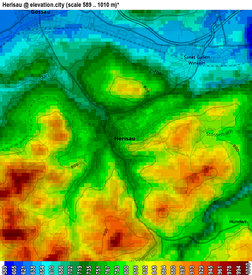
Below is the Elevation map of Herisau, which displays elevation range with different colors. Scale of the first map is from 589 to 1010 m (1932 to 3314 ft) with average elevation of 775.5 meters (=2544 ft) [note 1]
These maps also provides idea of topography and contour of this city, they are displayed at different zoom levels. More info about maps, scale and edge coordinates you can find below images.
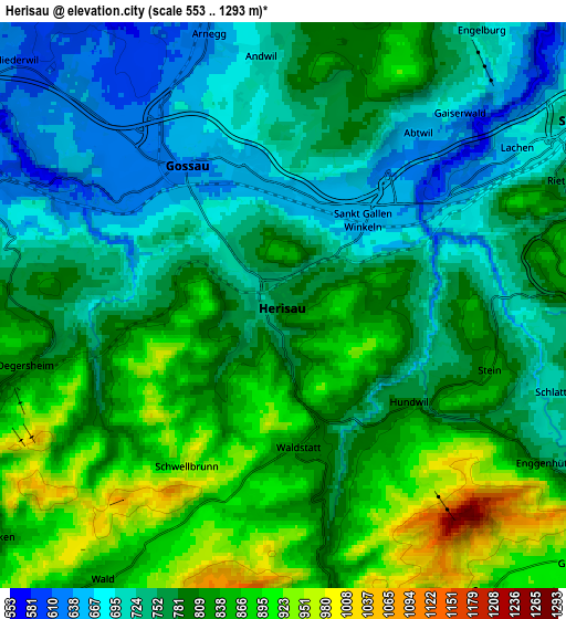
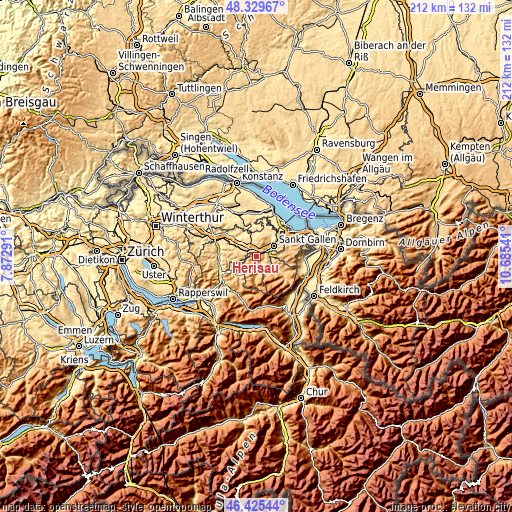
| \ | Map #1 | Map #2 | Topo.Map |
| Scale [m] | 589..1010 m | 553..1293 m | × |
| Scale [ft] | 1932..3314 ft | 1814..4242 ft | × |
| Average | 775.5 m = 2544 ft | 786.1 m = 2579 ft | × |
| Width | 6.62 km = 4.1 mi | 13.23 km = 8.2 mi | 211.7 km = 131.5 mi |
| Height | 6.62 km = 4.1 mi | 13.23 km = 8.2 mi | 211.7 km = 131.5 mi |
| ↑Max Latitude | 47.415895° | 47.445623° | 48.32967° |
| Latitude at center | 47.38615° | 47.38615° | 47.38615° |
| ↓Min Latitude | 47.356388° | 47.32661° | 46.42544° |
| ← Min Longitude | 9.235215° | 9.191269° | 7.87291° |
| Longitude center | 9.27916° | 9.27916° | 9.27916° |
| →Max Longitude | 9.323105° | 9.367051° | 10.68541° |
Nearby cities:
Cities around Herisau sort by population:
• Sankt Gallen elevation 684 m
8.3 km,  59°
59°
• Gossau 637 m
3.7 km,  330°
330°
• Flawil 621 m
7.8 km,  292°
292°
• Teufen 842 m
8.1 km,  86°
86°
• Degersheim 814 m
6.1 km,  257°
257°
• Waldkirch 627 m
9.2 km,  3°
3°
• Urnäsch 861 m
7.7 km,  179°
179°
• Andwil 711 m
5.8 km,  356°
356°
• Waldstatt 823 m
3.3 km,  174°
174°
• Schwellbrunn 962 m
4.4 km,  211°
211°
• Gonten 900 m
8.3 km,  142°
142°
• Haslen 745 m
6.9 km,  105°
105°
Multilingual:
 En español:
Herisau elevación 780 m.
 En France:
Herisau élévation 780 m.


Sources and notes:
- [note 1] Map square and city borders are not equal. Map elevation data is calculated only from area inside that square.
- [src 1] Elevation data from geonames database provided with same terms of usage.
- [src 2] The elevation map of Herisau is generated using elevation data from NASA's 3 arcsec (90m) resolution SRTM data.
- [src 3] Base (background) map © OpenStreetMap contributors tiles are generated by Geofabrik and OpenTopoMap.
Copyright & License:
This Herisau Elevation Map is licensed under CC BY-SA. You may reuse any part from this page, if you give a proper credit by linking to this URL:
 More info on terms of use page.