Sankt Gallen elevation
Sankt Gallen (Saint Gallen, Wahlkreis St. Gallen), Switzerland elevation is 684 meters and Sankt Gallen elevation in feet is 2244 ft above sea level [src 1]. Sankt Gallen is a seat of a first-order administrative division (feature code) with elevation that is 136 meters (446 ft) bigger than average city elevation in Switzerland.
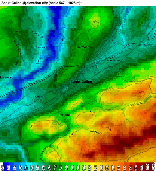
Below is the Elevation map of Sankt Gallen, which displays elevation range with different colors. Scale of the first map is from 547 to 1025 m (1795 to 3363 ft) with average elevation of 742.8 meters (=2437 ft) [note 1]
These maps also provides idea of topography and contour of this city, they are displayed at different zoom levels. More info about maps, scale and edge coordinates you can find below images.
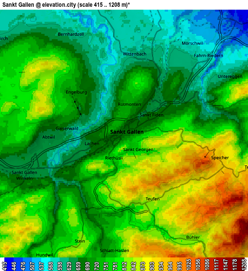
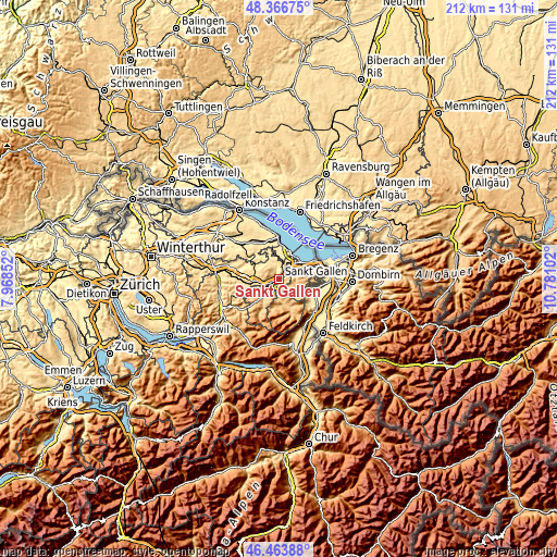
| \ | Map #1 | Map #2 | Topo.Map |
| Scale [m] | 547..1025 m | 415..1208 m | × |
| Scale [ft] | 1795..3363 ft | 1362..3963 ft | × |
| Average | 742.8 m = 2437 ft | 744.7 m = 2443 ft | × |
| Width | 6.61 km = 4.1 mi | 13.22 km = 8.2 mi | 211.6 km = 131.5 mi |
| Height | 6.61 km = 4.1 mi | 13.22 km = 8.2 mi | 211.6 km = 131.5 mi |
| ↑Max Latitude | 47.453634° | 47.48334° | 48.36675° |
| Latitude at center | 47.42391° | 47.42391° | 47.42391° |
| ↓Min Latitude | 47.39417° | 47.364412° | 46.46388° |
| ← Min Longitude | 9.330825° | 9.286879° | 7.96852° |
| Longitude center | 9.37477° | 9.37477° | 9.37477° |
| →Max Longitude | 9.418715° | 9.462661° | 10.78102° |
Nearby cities:
Cities around Sankt Gallen sort by population:
• Herisau elevation 780 m
8.3 km,  239°
239°
• Wittenbach 615 m
4.2 km,  11°
11°
• Teufen 842 m
3.8 km,  166°
166°
• Speicher 927 m
5.4 km,  105°
105°
• Mörschwil 541 m
6.4 km,  34°
34°
• Eggersriet 817 m
7.4 km,  74°
74°
• Rehetobel 946 m
8.1 km,  88°
88°
• Andwil 711 m
7.7 km,  282°
282°
• Trogen 904 m
7 km,  104°
104°
• Bühler 831 m
6.8 km,  145°
145°
• Häggenschwil 572 m
8.2 km,  344°
344°
• Haslen 745 m
6.1 km,  185°
185°
Multilingual:
 En español:
San Galo elevación 684 m.
 En France:
Saint-Gall élévation 684 m.
 Auf Deutsch:
St. Gallen höhe über dem Meeresspiegel ist 684 m.

Sources and notes:
- [note 1] Map square and city borders are not equal. Map elevation data is calculated only from area inside that square.
- [src 1] Elevation data from geonames database provided with same terms of usage.
- [src 2] The elevation map of Sankt Gallen is generated using elevation data from NASA's 3 arcsec (90m) resolution SRTM data.
- [src 3] Base (background) map © OpenStreetMap contributors tiles are generated by Geofabrik and OpenTopoMap.
Copyright & License:
This Sankt Gallen Elevation Map is licensed under CC BY-SA. You may reuse any part from this page, if you give a proper credit by linking to this URL:
 More info on terms of use page.