Cham elevation
Cham (Zug), Switzerland elevation is 424 meters and Cham elevation in feet is 1391 ft above sea level [src 1]. Cham is a populated place (feature code) with elevation that is 124 meters (407 ft) smaller than average city elevation in Switzerland.
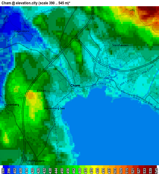
Below is the Elevation map of Cham, which displays elevation range with different colors. Scale of the first map is from 390 to 545 m (1280 to 1788 ft) with average elevation of 428.7 meters (=1406 ft) [note 1]
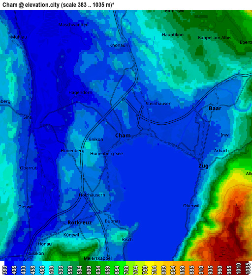
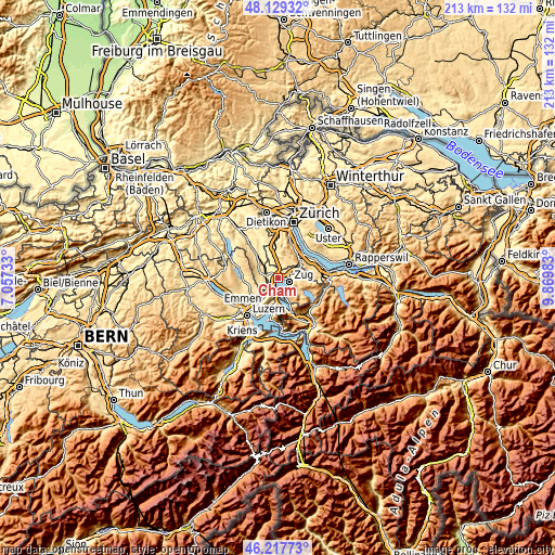
These maps also provides idea of topography and contour of this city, they are displayed at different zoom levels. More info about maps, scale and edge coordinates you can find below images.
| \ | Map #1 | Map #2 | Topo.Map |
| Scale [m] | 390..545 m | 383..1035 m | × |
| Scale [ft] | 1280..1788 ft | 1257..3396 ft | × |
| Average | 428.7 m = 1406 ft | 481.5 m = 1580 ft | × |
| Width | 6.64 km = 4.1 mi | 13.28 km = 8.3 mi | 212.5 km = 132 mi |
| Height | 6.64 km = 4.1 mi | 13.28 km = 8.3 mi | 212.5 km = 132 mi |
| ↑Max Latitude | 47.21199° | 47.241833° | 48.12932° |
| Latitude at center | 47.18213° | 47.18213° | 47.18213° |
| ↓Min Latitude | 47.152253° | 47.12236° | 46.21773° |
| ← Min Longitude | 8.419635° | 8.375689° | 7.05733° |
| Longitude center | 8.46358° | 8.46358° | 8.46358° |
| →Max Longitude | 8.507525° | 8.551471° | 9.86983° |
Nearby cities:
Cities around Cham sort by population:
• Zug elevation 424 m
4.2 km,  104°
104°
• Baar 447 m
5.2 km,  72°
72°
• Rotkreuz 427 m
5 km,  209°
209°
• Hünenberg 449 m
3 km,  255°
255°
• Steinhausen 425 m
2.2 km,  49°
49°
• Sins 425 m
5.4 km,  282°
282°
• Hausen am Albis / Hausen (Dorf) 613 m
8.7 km,  36°
36°
• Mettmenstetten 473 m
7 km,  359°
359°
• Auw 485 m
8 km,  293°
293°
• Oberrüti 415 m
5.5 km,  251°
251°
• Meierskappel 503 m
6.6 km,  193°
193°
• Knonau 431 m
4.6 km, 358°
Multilingual:
 En español:
Cham elevación 424 m.
 En France:
Cham élévation 424 m.


Sources and notes:
- [note 1] Map square and city borders are not equal. Map elevation data is calculated only from area inside that square.
- [src 1] Elevation data from geonames database provided with same terms of usage.
- [src 2] The elevation map of Cham is generated using elevation data from NASA's 3 arcsec (90m) resolution SRTM data.
- [src 3] Base (background) map © OpenStreetMap contributors tiles are generated by Geofabrik and OpenTopoMap.
Copyright & License:
This Cham Elevation Map is licensed under CC BY-SA. You may reuse any part from this page, if you give a proper credit by linking to this URL:
 More info on terms of use page.