Sins elevation
Sins (Aargau, Bezirk Muri), Switzerland elevation is 425 meters and Sins elevation in feet is 1394 ft above sea level [src 1]. Sins is a populated place (feature code) with elevation that is 123 meters (404 ft) smaller than average city elevation in Switzerland.
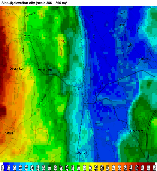
Below is the Elevation map of Sins, which displays elevation range with different colors. Scale of the first map is from 386 to 596 m (1266 to 1955 ft) with average elevation of 452.3 meters (=1484 ft) [note 1]
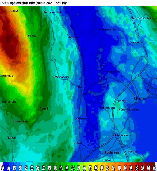
These maps also provides idea of topography and contour of this city, they are displayed at different zoom levels. More info about maps, scale and edge coordinates you can find below images.
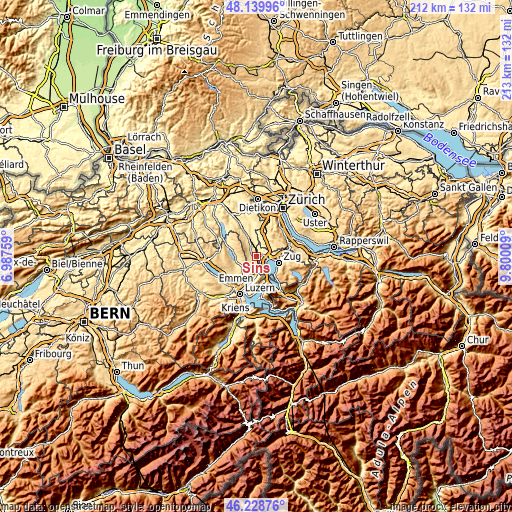
| \ | Map #1 | Map #2 | Topo.Map |
| Scale [m] | 386..596 m | 382..881 m | × |
| Scale [ft] | 1266..1955 ft | 1253..2890 ft | × |
| Average | 452.3 m = 1484 ft | 491.2 m = 1612 ft | × |
| Width | 6.64 km = 4.1 mi | 13.28 km = 8.3 mi | 212.5 km = 132 mi |
| Height | 6.64 km = 4.1 mi | 13.28 km = 8.3 mi | 212.5 km = 132 mi |
| ↑Max Latitude | 47.222814° | 47.252651° | 48.13996° |
| Latitude at center | 47.19296° | 47.19296° | 47.19296° |
| ↓Min Latitude | 47.163089° | 47.133202° | 46.22876° |
| ← Min Longitude | 8.349895° | 8.305949° | 6.98759° |
| Longitude center | 8.39384° | 8.39384° | 8.39384° |
| →Max Longitude | 8.437785° | 8.481731° | 9.80009° |
Nearby cities:
Cities around Sins sort by population:
• Cham elevation 424 m
5.4 km,  102°
102°
• Rotkreuz 427 m
6.3 km,  153°
153°
• Hünenberg 449 m
3.1 km,  129°
129°
• Steinhausen 425 m
7 km,  88°
88°
• Mettmenstetten 473 m
7.8 km,  42°
42°
• Merenschwand 389 m
7.5 km,  349°
349°
• Ballwil 502 m
6.9 km,  231°
231°
• Hohenrain 604 m
5.9 km,  256°
256°
• Auw 485 m
2.9 km,  313°
313°
• Oberrüti 415 m
2.9 km,  179°
179°
• Obfelden / Oberlunnern 426 m
7.9 km,  12°
12°
• Knonau 431 m
6.2 km,  56°
56°
Multilingual:
 En español:
Sins elevación 425 m.
 En France:
Sins élévation 425 m.


Sources and notes:
- [note 1] Map square and city borders are not equal. Map elevation data is calculated only from area inside that square.
- [src 1] Elevation data from geonames database provided with same terms of usage.
- [src 2] The elevation map of Sins is generated using elevation data from NASA's 3 arcsec (90m) resolution SRTM data.
- [src 3] Base (background) map © OpenStreetMap contributors tiles are generated by Geofabrik and OpenTopoMap.
Copyright & License:
This Sins Elevation Map is licensed under CC BY-SA. You may reuse any part from this page, if you give a proper credit by linking to this URL:
 More info on terms of use page.