Conthey elevation
Conthey (Valais, Conthey District), Switzerland elevation is 491 meters and Conthey elevation in feet is 1611 ft above sea level [src 1]. Conthey is a seat of a second-order administrative division (feature code) with elevation that is 57 meters (187 ft) smaller than average city elevation in Switzerland.
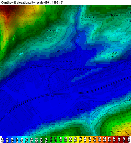
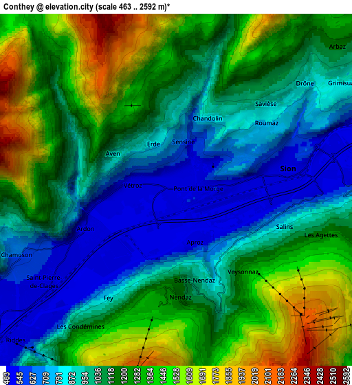
Below is the Elevation map of Conthey, which displays elevation range with different colors. Scale of the first map is from 470 to 1896 m (1542 to 6220 ft) with average elevation of 698.6 meters (=2292 ft) [note 1]
These maps also provides idea of topography and contour of this city, they are displayed at different zoom levels. More info about maps, scale and edge coordinates you can find below images.
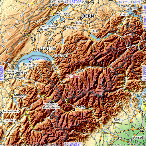
| \ | Map #1 | Map #2 | Topo.Map |
| Scale [m] | 470..1896 m | 463..2592 m | × |
| Scale [ft] | 1542..6220 ft | 1519..8504 ft | × |
| Average | 698.6 m = 2292 ft | 1115.3 m = 3659 ft | × |
| Width | 6.76 km = 4.2 mi | 13.52 km = 8.4 mi | 216.4 km = 134.5 mi |
| Height | 6.76 km = 4.2 mi | 13.52 km = 8.4 mi | 216.3 km = 134.4 mi |
| ↑Max Latitude | 46.254095° | 46.284473° | 47.18799° |
| Latitude at center | 46.2237° | 46.2237° | 46.2237° |
| ↓Min Latitude | 46.193288° | 46.16286° | 45.24217° |
| ← Min Longitude | 7.258885° | 7.214939° | 5.89658° |
| Longitude center | 7.30283° | 7.30283° | 7.30283° |
| →Max Longitude | 7.346775° | 7.390721° | 8.70908° |
Nearby cities:
Cities around Conthey sort by population:
• Sitten elevation 487 m
4.1 km,  84°
84°
• Savièse 840 m
4.5 km,  47°
47°
• Basse-Nendaz 1004 m
3.8 km,  169°
169°
• Vétroz 482 m
1.9 km,  263°
263°
• Chamoson 650 m
6.6 km,  249°
249°
• Grimisuat 863 m
7.4 km,  57°
57°
• Ardon 487 m
3.6 km,  244°
244°
• Riddes 499 m
8.3 km,  227°
227°
• Leytron 491 m
8.4 km, 240°
• Saint-Léonard 506 m
9.3 km,  70°
70°
• Vex 929 m
7.4 km,  99°
99°
• Hérémence 1225 m
9.2 km,  121°
121°
Multilingual:
 En español:
Conthey elevación 491 m.
 En France:
Conthey élévation 491 m.


Sources and notes:
- [note 1] Map square and city borders are not equal. Map elevation data is calculated only from area inside that square.
- [src 1] Elevation data from geonames database provided with same terms of usage.
- [src 2] The elevation map of Conthey is generated using elevation data from NASA's 3 arcsec (90m) resolution SRTM data.
- [src 3] Base (background) map © OpenStreetMap contributors tiles are generated by Geofabrik and OpenTopoMap.
Copyright & License:
This Conthey Elevation Map is licensed under CC BY-SA. You may reuse any part from this page, if you give a proper credit by linking to this URL:
 More info on terms of use page.