Saint-Léonard elevation
Saint-Léonard (Valais, Sion District), Switzerland elevation is 506 meters and Saint-Léonard elevation in feet is 1660 ft above sea level [src 1]. Saint-Léonard is a populated place (feature code) with elevation that is 42 meters (138 ft) smaller than average city elevation in Switzerland.
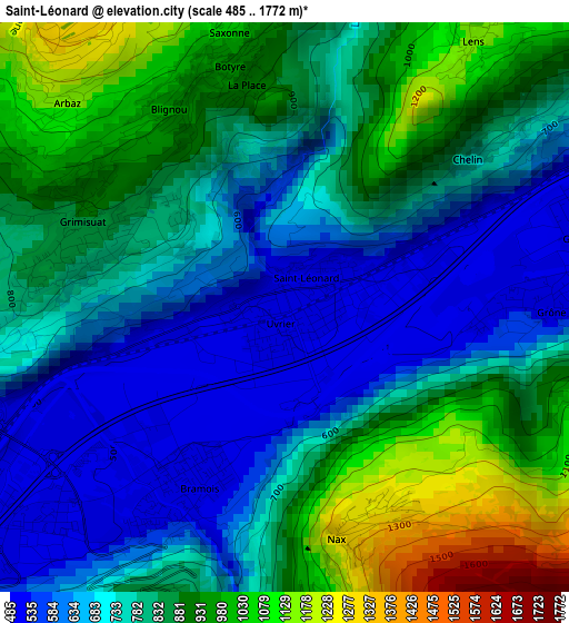
Below is the Elevation map of Saint-Léonard, which displays elevation range with different colors. Scale of the first map is from 485 to 1772 m (1591 to 5814 ft) with average elevation of 797.6 meters (=2617 ft) [note 1]
These maps also provides idea of topography and contour of this city, they are displayed at different zoom levels. More info about maps, scale and edge coordinates you can find below images.
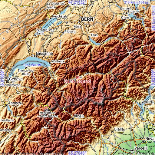
| \ | Map #1 | Topo.Map |
| Scale [m] | 485..1772 m | × |
| Scale [ft] | 1591..5814 ft | × |
| Average | 797.6 m = 2617 ft | × |
| Width | 6.76 km = 4.2 mi | 216.2 km = 134.3 mi |
| Height | 6.76 km = 4.2 mi | 216.2 km = 134.3 mi |
| ↑Max Latitude | 46.281899° | 47.21532° |
| Latitude at center | 46.25152° | 46.25152° |
| ↓Min Latitude | 46.221124° | 45.27048° |
| ← Min Longitude | 7.373195° | 6.01089° |
| Longitude center | 7.41714° | 7.41714° |
| →Max Longitude | 7.461085° | 8.82339° |
Nearby cities:
Cities around Saint-Léonard sort by population:
• Sitten elevation 487 m
5.4 km,  240°
240°
• Savièse 840 m
5.5 km,  269°
269°
• Lens 1177 m
4.3 km,  35°
35°
• Ayent 1057 m
3.5 km,  351°
351°
• Randogne 1236 m
9.1 km, 44°
• Chermignon-d’en Haut 1149 m
6 km,  47°
47°
• Chalais 512 m
7.5 km,  76°
76°
• Grimisuat 863 m
2.7 km,  288°
288°
• Montana 1495 m
8.8 km, 38°
• Grône 503 m
3.3 km,  87°
87°
• Vex 929 m
4.6 km,  198°
198°
• Hérémence 1225 m
8 km,  186°
186°
Multilingual:
 En español:
Saint-Léonard elevación 506 m.
 En France:
Saint-Léonard élévation 506 m.
 Auf Deutsch:
Saint-Léonard VS höhe über dem Meeresspiegel ist 506 m.

Sources and notes:
- [note 1] Map square and city borders are not equal. Map elevation data is calculated only from area inside that square.
- [src 1] Elevation data from geonames database provided with same terms of usage.
- [src 2] The elevation map of Saint-Léonard is generated using elevation data from NASA's 3 arcsec (90m) resolution SRTM data.
- [src 3] Base (background) map © OpenStreetMap contributors tiles are generated by Geofabrik and OpenTopoMap.
Copyright & License:
This Saint-Léonard Elevation Map is licensed under CC BY-SA. You may reuse any part from this page, if you give a proper credit by linking to this URL:
 More info on terms of use page.