Dietikon elevation
Dietikon (Zurich, Bezirk Dietikon), Switzerland elevation is 397 meters and Dietikon elevation in feet is 1302 ft above sea level [src 1]. Dietikon is a populated place (feature code) with elevation that is 151 meters (495 ft) smaller than average city elevation in Switzerland.
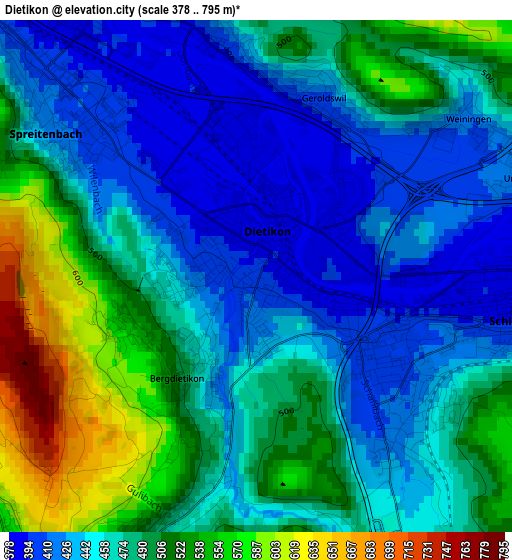
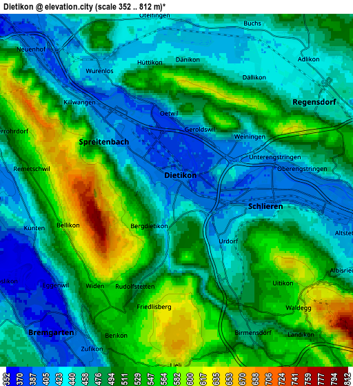
Below is the Elevation map of Dietikon, which displays elevation range with different colors. Scale of the first map is from 378 to 795 m (1240 to 2608 ft) with average elevation of 474.3 meters (=1556 ft) [note 1]
These maps also provides idea of topography and contour of this city, they are displayed at different zoom levels. More info about maps, scale and edge coordinates you can find below images.
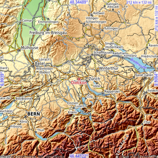
| \ | Map #1 | Map #2 | Topo.Map |
| Scale [m] | 378..795 m | 352..812 m | × |
| Scale [ft] | 1240..2608 ft | 1155..2664 ft | × |
| Average | 474.3 m = 1556 ft | 488.8 m = 1604 ft | × |
| Width | 6.61 km = 4.1 mi | 13.23 km = 8.2 mi | 211.7 km = 131.5 mi |
| Height | 6.61 km = 4.1 mi | 13.23 km = 8.2 mi | 211.7 km = 131.5 mi |
| ↑Max Latitude | 47.431386° | 47.461106° | 48.34489° |
| Latitude at center | 47.40165° | 47.40165° | 47.40165° |
| ↓Min Latitude | 47.371897° | 47.342127° | 46.44122° |
| ← Min Longitude | 8.356205° | 8.312259° | 6.9939° |
| Longitude center | 8.40015° | 8.40015° | 8.40015° |
| →Max Longitude | 8.444095° | 8.488041° | 9.8064° |
Nearby cities:
Cities around Dietikon sort by population:
• Urdorf elevation 424 m
2.7 km,  133°
133°
• Dietikon / Oberdorf 408 m
0.5 km,  256°
256°
• Geroldswil 403 m
2.4 km,  19°
19°
• Dietikon / Hofacker 393 m
1.3 km,  112°
112°
• Dietikon / Vorstadt 387 m
0.8 km,  342°
342°
• Schlieren / Spital 410 m
2.4 km, 108°
• Dietikon / Almend 400 m
0.7 km,  298°
298°
• Dietikon / Kreuzacker 407 m
0.3 km,  160°
160°
• Urdorf / Bodenfeld 410 m
2.2 km, 129°
• Dietikon / Guggenbühl 389 m
0.6 km, 106°
• Urdorf / Moos 426 m
2.5 km,  121°
121°
• Dietikon / Schönenwerd 396 m
2 km,  104°
104°
Multilingual:
 En español:
Dietikon elevación 397 m.
 En France:
Dietikon élévation 397 m.
 Auf Deutsch:
Dietikon höhe über dem Meeresspiegel ist 397 m.

Sources and notes:
- [note 1] Map square and city borders are not equal. Map elevation data is calculated only from area inside that square.
- [src 1] Elevation data from geonames database provided with same terms of usage.
- [src 2] The elevation map of Dietikon is generated using elevation data from NASA's 3 arcsec (90m) resolution SRTM data.
- [src 3] Base (background) map © OpenStreetMap contributors tiles are generated by Geofabrik and OpenTopoMap.
Copyright & License:
This Dietikon Elevation Map is licensed under CC BY-SA. You may reuse any part from this page, if you give a proper credit by linking to this URL:
 More info on terms of use page.