Frauenfeld elevation
Frauenfeld (Thurgau, Frauenfeld District), Switzerland elevation is 418 meters and Frauenfeld elevation in feet is 1371 ft above sea level [src 1]. Frauenfeld is a seat of a first-order administrative division (feature code) with elevation that is 130 meters (427 ft) smaller than average city elevation in Switzerland.
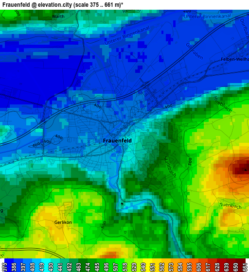
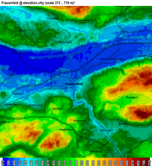
Below is the Elevation map of Frauenfeld, which displays elevation range with different colors. Scale of the first map is from 375 to 661 m (1230 to 2169 ft) with average elevation of 448.7 meters (=1472 ft) [note 1]
These maps also provides idea of topography and contour of this city, they are displayed at different zoom levels. More info about maps, scale and edge coordinates you can find below images.
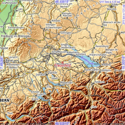
| \ | Map #1 | Map #2 | Topo.Map |
| Scale [m] | 375..661 m | 373..719 m | × |
| Scale [ft] | 1230..2169 ft | 1224..2359 ft | × |
| Average | 448.7 m = 1472 ft | 482.8 m = 1584 ft | × |
| Width | 6.59 km = 4.1 mi | 13.19 km = 8.2 mi | 211 km = 131.1 mi |
| Height | 6.59 km = 4.1 mi | 13.19 km = 8.2 mi | 211 km = 131.1 mi |
| ↑Max Latitude | 47.587408° | 47.617039° | 48.49818° |
| Latitude at center | 47.55776° | 47.55776° | 47.55776° |
| ↓Min Latitude | 47.528095° | 47.498414° | 46.60015° |
| ← Min Longitude | 8.854985° | 8.811039° | 7.49268° |
| Longitude center | 8.89893° | 8.89893° | 8.89893° |
| →Max Longitude | 8.942875° | 8.986821° | 10.30518° |
Nearby cities:
Cities around Frauenfeld sort by population:
• Aadorf elevation 526 m
7.3 km,  178°
178°
• Wängi 470 m
7.9 km,  149°
149°
• Elgg 508 m
7.2 km,  200°
200°
• Gachnang 451 m
4 km,  239°
239°
• Matzingen 445 m
5 km, 148°
• Elgg / Städtchen und Umgebung 529 m
7.6 km, 198°
• Pfyn 410 m
6 km,  43°
43°
• Wiesendangen / Wiesendangen (Dorf) 470 m
9.1 km, 243°
• Hüttwilen 465 m
5.8 km,  340°
340°
• Sulz 455 m
8.5 km,  256°
256°
• Thundorf 546 m
5 km,  105°
105°
• Stettfurt 482 m
5.4 km,  131°
131°
Multilingual:
 En español:
Frauenfeld elevación 418 m.
 En France:
Frauenfeld élévation 418 m.
 Auf Deutsch:
Frauenfeld höhe über dem Meeresspiegel ist 418 m.

Sources and notes:
- [note 1] Map square and city borders are not equal. Map elevation data is calculated only from area inside that square.
- [src 1] Elevation data from geonames database provided with same terms of usage.
- [src 2] The elevation map of Frauenfeld is generated using elevation data from NASA's 3 arcsec (90m) resolution SRTM data.
- [src 3] Base (background) map © OpenStreetMap contributors tiles are generated by Geofabrik and OpenTopoMap.
Copyright & License:
This Frauenfeld Elevation Map is licensed under CC BY-SA. You may reuse any part from this page, if you give a proper credit by linking to this URL:
 More info on terms of use page.