Elgg / Städtchen und Umgebung elevation
Elgg / Städtchen und Umgebung (Zurich, Bezirk Winterthur), Switzerland elevation is 529 meters and Elgg / Städtchen und Umgebung elevation in feet is 1736 ft above sea level [src 1]. Elgg / Städtchen und Umgebung is a section of populated place (feature code) with elevation that is 19 meters (62 ft) smaller than average city elevation in Switzerland.
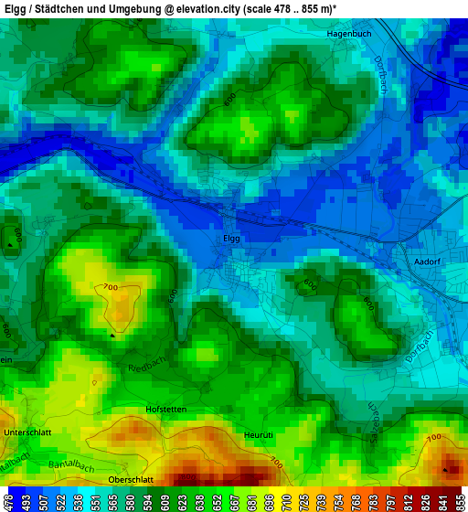
Below is the Elevation map of Elgg / Städtchen und Umgebung, which displays elevation range with different colors. Scale of the first map is from 478 to 855 m (1568 to 2805 ft) with average elevation of 591.1 meters (=1939 ft) [note 1]
These maps also provides idea of topography and contour of this city, they are displayed at different zoom levels. More info about maps, scale and edge coordinates you can find below images.
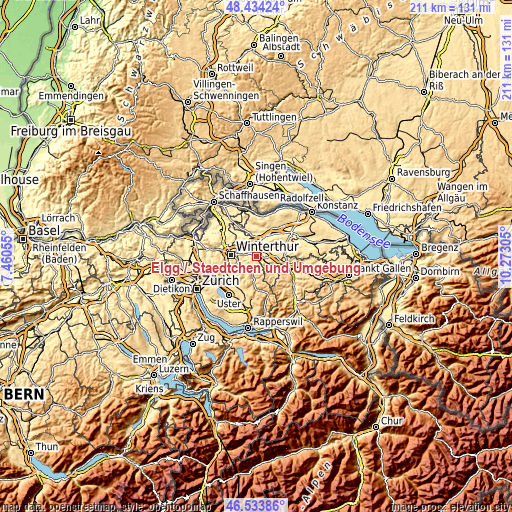
| \ | Map #1 | Topo.Map |
| Scale [m] | 478..855 m | × |
| Scale [ft] | 1568..2805 ft | × |
| Average | 591.1 m = 1939 ft | × |
| Width | 6.6 km = 4.1 mi | 211.3 km = 131.3 mi |
| Height | 6.6 km = 4.1 mi | 211.3 km = 131.3 mi |
| ↑Max Latitude | 47.522335° | 48.43424° |
| Latitude at center | 47.49265° | 47.49265° |
| ↓Min Latitude | 47.462948° | 46.53386° |
| ← Min Longitude | 8.822855° | 7.46055° |
| Longitude center | 8.8668° | 8.8668° |
| →Max Longitude | 8.910745° | 10.27305° |
Nearby cities:
Cities around Elgg / Städtchen und Umgebung sort by population:
• Aadorf elevation 526 m
2.6 km,  91°
91°
• Wängi 470 m
6.5 km, 86°
• Elgg 508 m
0.5 km,  346°
346°
• Gachnang 451 m
5.3 km, 348°
• Turbenthal 555 m
6.4 km,  193°
193°
• Matzingen 445 m
5.8 km,  59°
59°
• Seen (Kreis 3) / Oberseen 485 m
7.2 km,  260°
260°
• Kollbrunn 526 m
7.4 km,  238°
238°
• Wiesendangen / Wiesendangen (Dorf) 470 m
6.6 km,  299°
299°
• Oberwinterthur (Kreis 2) / Hegi 468 m
7.4 km,  282°
282°
• Elsau-Räterschen 505 m
5.2 km, 281°
• Elsau-Räterschen / Räterschen 477 m
5.4 km, 277°
Multilingual:
 En español:
Elgg / Städtchen und Umgebung elevación 529 m.
 En France:
Elgg / Städtchen und Umgebung élévation 529 m.
 Auf Deutsch:
Elgg / Städtchen höhe über dem Meeresspiegel ist 529 m.
 На русском:
Elgg / Städtchen und Umgebung высота над уровнем моря 529 м
Sources and notes:
- [note 1] Map square and city borders are not equal. Map elevation data is calculated only from area inside that square.
- [src 1] Elevation data from geonames database provided with same terms of usage.
- [src 2] The elevation map of Elgg / Städtchen und Umgebung is generated using elevation data from NASA's 3 arcsec (90m) resolution SRTM data.
- [src 3] Base (background) map © OpenStreetMap contributors tiles are generated by Geofabrik and OpenTopoMap.
Copyright & License:
This Elgg / Städtchen und Umgebung Elevation Map is licensed under CC BY-SA. You may reuse any part from this page, if you give a proper credit by linking to this URL:
 More info on terms of use page.