Fulenbach elevation
Fulenbach (Solothurn, Bezirk Olten), Switzerland elevation is 406 meters and Fulenbach elevation in feet is 1332 ft above sea level [src 1]. Fulenbach is a populated place (feature code) with elevation that is 142 meters (466 ft) smaller than average city elevation in Switzerland.
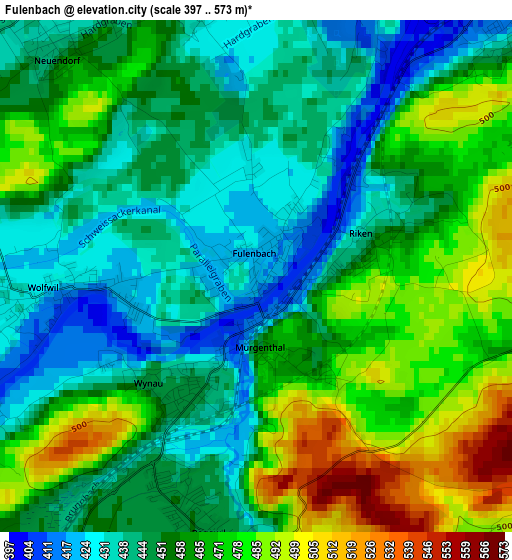
Below is the Elevation map of Fulenbach, which displays elevation range with different colors. Scale of the first map is from 397 to 573 m (1302 to 1880 ft) with average elevation of 458 meters (=1503 ft) [note 1]
These maps also provides idea of topography and contour of this city, they are displayed at different zoom levels. More info about maps, scale and edge coordinates you can find below images.
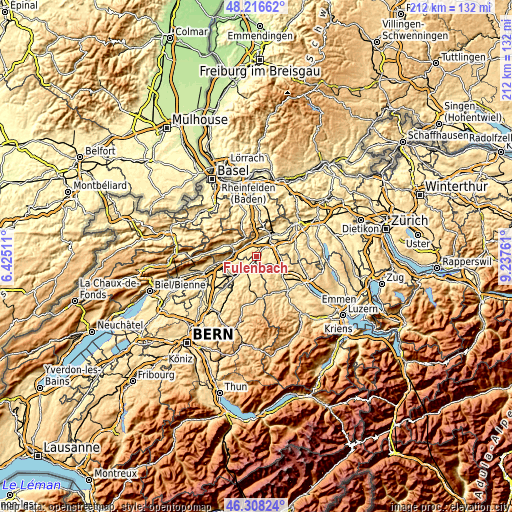
| \ | Map #1 | Topo.Map |
| Scale [m] | 397..573 m | × |
| Scale [ft] | 1302..1880 ft | × |
| Average | 458 m = 1503 ft | × |
| Width | 6.63 km = 4.1 mi | 212.2 km = 131.9 mi |
| Height | 6.63 km = 4.1 mi | 212.2 km = 131.9 mi |
| ↑Max Latitude | 47.30084° | 48.21662° |
| Latitude at center | 47.27103° | 47.27103° |
| ↓Min Latitude | 47.241203° | 46.30824° |
| ← Min Longitude | 7.787415° | 6.42511° |
| Longitude center | 7.83136° | 7.83136° |
| →Max Longitude | 7.875305° | 9.23761° |
Nearby cities:
Cities around Fulenbach sort by population:
• Langenthal elevation 478 m
6.7 km,  203°
203°
• Rothrist 410 m
5.9 km,  50°
50°
• Aarwangen 454 m
6 km,  232°
232°
• Roggwil 450 m
3.4 km,  192°
192°
• Murgenthal 409 m
0.6 km,  85°
85°
• Egerkingen 433 m
6.5 km,  326°
326°
• Wolfwil 417 m
2.6 km,  264°
264°
• Pfaffnau 504 m
6.9 km,  134°
134°
• Oberbuchsiten 471 m
6.7 km,  314°
314°
• Vordemwald 428 m
5.3 km,  84°
84°
• Wynau 448 m
2.1 km,  213°
213°
• Gunzgen 437 m
4.8 km,  359°
359°
Multilingual:
 En español:
Fulenbach elevación 406 m.
 En France:
Fulenbach élévation 406 m.
 Auf Deutsch:
Fulenbach höhe über dem Meeresspiegel ist 406 m.

Sources and notes:
- [note 1] Map square and city borders are not equal. Map elevation data is calculated only from area inside that square.
- [src 1] Elevation data from geonames database provided with same terms of usage.
- [src 2] The elevation map of Fulenbach is generated using elevation data from NASA's 3 arcsec (90m) resolution SRTM data.
- [src 3] Base (background) map © OpenStreetMap contributors tiles are generated by Geofabrik and OpenTopoMap.
Copyright & License:
This Fulenbach Elevation Map is licensed under CC BY-SA. You may reuse any part from this page, if you give a proper credit by linking to this URL:
 More info on terms of use page.