Langenthal elevation
Langenthal (Bern, Oberaargau), Switzerland elevation is 478 meters and Langenthal elevation in feet is 1568 ft above sea level [src 1]. Langenthal is a populated place (feature code) with elevation that is 70 meters (230 ft) smaller than average city elevation in Switzerland.
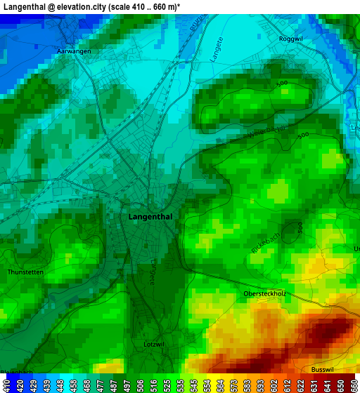
Below is the Elevation map of Langenthal, which displays elevation range with different colors. Scale of the first map is from 410 to 660 m (1345 to 2165 ft) with average elevation of 497 meters (=1631 ft) [note 1]
These maps also provides idea of topography and contour of this city, they are displayed at different zoom levels. More info about maps, scale and edge coordinates you can find below images.
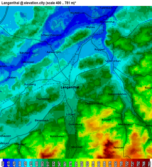
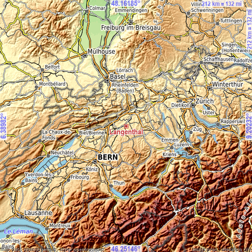
| \ | Map #1 | Map #2 | Topo.Map |
| Scale [m] | 410..660 m | 400..781 m | × |
| Scale [ft] | 1345..2165 ft | 1312..2562 ft | × |
| Average | 497 m = 1631 ft | 512.8 m = 1682 ft | × |
| Width | 6.64 km = 4.1 mi | 13.28 km = 8.3 mi | 212.4 km = 132 mi |
| Height | 6.64 km = 4.1 mi | 13.28 km = 8.3 mi | 212.4 km = 132 mi |
| ↑Max Latitude | 47.245101° | 47.274926° | 48.16185° |
| Latitude at center | 47.21526° | 47.21526° | 47.21526° |
| ↓Min Latitude | 47.185402° | 47.155527° | 46.25146° |
| ← Min Longitude | 7.752125° | 7.708179° | 6.38982° |
| Longitude center | 7.79607° | 7.79607° | 7.79607° |
| →Max Longitude | 7.840015° | 7.883961° | 9.20232° |
Nearby cities:
Cities around Langenthal sort by population:
• Herzogenbuchsee elevation 474 m
7.4 km,  245°
245°
• Aarwangen 454 m
3.3 km,  321°
321°
• Roggwil 450 m
3.5 km,  33°
33°
• Murgenthal 409 m
7.1 km, 27°
• Lotzwil 500 m
2.7 km,  188°
188°
• Wolfwil 417 m
5.9 km,  0°
0°
• Pfaffnau 504 m
7.8 km,  79°
79°
• Madiswil 538 m
5.6 km,  178°
178°
• Wynau 448 m
4.7 km,  18°
18°
• Fulenbach 406 m
6.7 km, 23°
• Melchnau 531 m
5.6 km,  131°
131°
• Busswil bei Melchnau 572 m
4.2 km,  140°
140°
Multilingual:
 En español:
Langenthal elevación 478 m.
 En France:
Langenthal élévation 478 m.
 Auf Deutsch:
Langenthal höhe über dem Meeresspiegel ist 478 m.

Sources and notes:
- [note 1] Map square and city borders are not equal. Map elevation data is calculated only from area inside that square.
- [src 1] Elevation data from geonames database provided with same terms of usage.
- [src 2] The elevation map of Langenthal is generated using elevation data from NASA's 3 arcsec (90m) resolution SRTM data.
- [src 3] Base (background) map © OpenStreetMap contributors tiles are generated by Geofabrik and OpenTopoMap.
Copyright & License:
This Langenthal Elevation Map is licensed under CC BY-SA. You may reuse any part from this page, if you give a proper credit by linking to this URL:
 More info on terms of use page.