Martigny-Ville elevation
Martigny-Ville (Valais, Martigny District), Switzerland elevation is 475 meters and Martigny-Ville elevation in feet is 1558 ft above sea level [src 1]. Martigny-Ville is a seat of a second-order administrative division (feature code) with elevation that is 73 meters (240 ft) smaller than average city elevation in Switzerland.
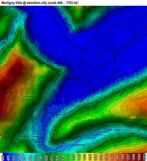
Below is the Elevation map of Martigny-Ville, which displays elevation range with different colors. Scale of the first map is from 440 to 1703 m (1444 to 5587 ft) with average elevation of 754.4 meters (=2475 ft) [note 1]
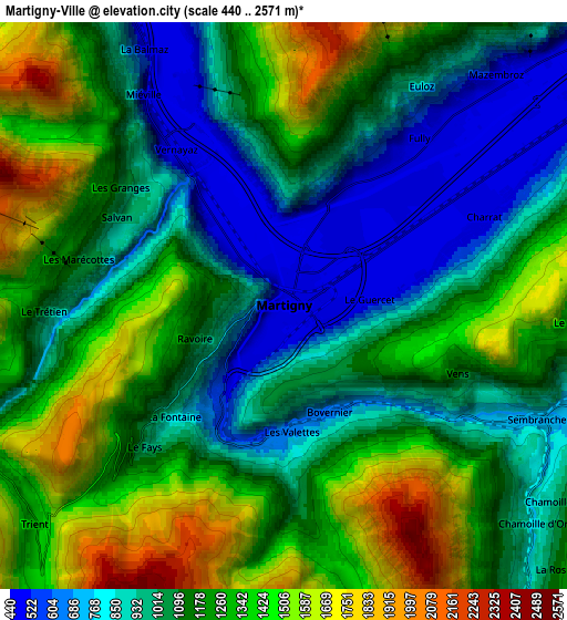
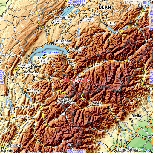
These maps also provides idea of topography and contour of this city, they are displayed at different zoom levels. More info about maps, scale and edge coordinates you can find below images.
| \ | Map #1 | Map #2 | Topo.Map |
| Scale [m] | 440..1703 m | 440..2571 m | × |
| Scale [ft] | 1444..5587 ft | 1444..8435 ft | × |
| Average | 754.4 m = 2475 ft | 1151.8 m = 3779 ft | × |
| Width | 6.78 km = 4.2 mi | 13.55 km = 8.4 mi | 216.8 km = 134.7 mi |
| Height | 6.78 km = 4.2 mi | 13.55 km = 8.4 mi | 216.8 km = 134.7 mi |
| ↑Max Latitude | 46.133222° | 46.163667° | 47.06919° |
| Latitude at center | 46.10276° | 46.10276° | 46.10276° |
| ↓Min Latitude | 46.072281° | 46.041786° | 45.11909° |
| ← Min Longitude | 7.028505° | 6.984559° | 5.6662° |
| Longitude center | 7.07245° | 7.07245° | 7.07245° |
| →Max Longitude | 7.116395° | 7.160341° | 8.4787° |
Nearby cities:
Cities around Martigny-Ville sort by population:
• Bagnes elevation 924 m
11.3 km,  100°
100°
• Fully 471 m
5.1 km,  39°
39°
• Saint-Maurice 419 m
13.9 km,  337°
337°
• Saxon 470 m
9.5 km,  56°
56°
• Orsières 897 m
9.9 km,  145°
145°
• Verbier 1515 m
11.9 km,  91°
91°
• Martigny-Combe 579 m
3.2 km,  211°
211°
• Vernayaz 455 m
4.6 km,  325°
325°
• Saillon 466 m
11.6 km,  49°
49°
• Charrat 461 m
5.2 km, 61°
• Salvan 923 m
4.4 km,  294°
294°
• Evionnaz 492 m
9.5 km, 336°
Multilingual:
 En español:
Martigny-Ville elevación 475 m.
 En France:
Martigny-Ville élévation 475 m.
 Auf Deutsch:
Martigny-Ville höhe über dem Meeresspiegel ist 475 m.

Sources and notes:
- [note 1] Map square and city borders are not equal. Map elevation data is calculated only from area inside that square.
- [src 1] Elevation data from geonames database provided with same terms of usage.
- [src 2] The elevation map of Martigny-Ville is generated using elevation data from NASA's 3 arcsec (90m) resolution SRTM data.
- [src 3] Base (background) map © OpenStreetMap contributors tiles are generated by Geofabrik and OpenTopoMap.
Copyright & License:
This Martigny-Ville Elevation Map is licensed under CC BY-SA. You may reuse any part from this page, if you give a proper credit by linking to this URL:
 More info on terms of use page.