Saint-Maurice elevation
Saint-Maurice (Valais, Saint-Maurice District), Switzerland elevation is 419 meters and Saint-Maurice elevation in feet is 1375 ft above sea level [src 1]. Saint-Maurice is a seat of a second-order administrative division (feature code) with elevation that is 129 meters (423 ft) smaller than average city elevation in Switzerland.
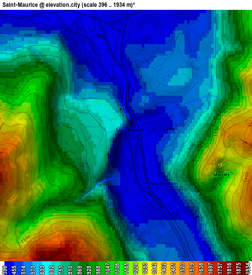
Below is the Elevation map of Saint-Maurice, which displays elevation range with different colors. Scale of the first map is from 396 to 1934 m (1299 to 6345 ft) with average elevation of 809.6 meters (=2656 ft) [note 1]
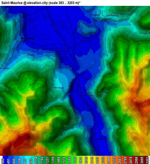
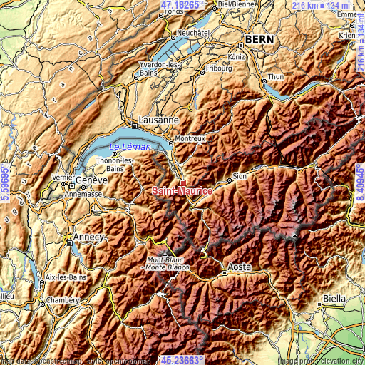
These maps also provides idea of topography and contour of this city, they are displayed at different zoom levels. More info about maps, scale and edge coordinates you can find below images.
| \ | Map #1 | Map #2 | Topo.Map |
| Scale [m] | 396..1934 m | 383..3203 m | × |
| Scale [ft] | 1299..6345 ft | 1257..10509 ft | × |
| Average | 809.6 m = 2656 ft | 1193.9 m = 3917 ft | × |
| Width | 6.76 km = 4.2 mi | 13.52 km = 8.4 mi | 216.4 km = 134.5 mi |
| Height | 6.76 km = 4.2 mi | 13.52 km = 8.4 mi | 216.4 km = 134.5 mi |
| ↑Max Latitude | 46.248658° | 46.279039° | 47.18265° |
| Latitude at center | 46.21826° | 46.21826° | 46.21826° |
| ↓Min Latitude | 46.187845° | 46.157414° | 45.23663° |
| ← Min Longitude | 6.959255° | 6.915309° | 5.59695° |
| Longitude center | 7.0032° | 7.0032° | 7.0032° |
| →Max Longitude | 7.047145° | 7.091091° | 8.40945° |
Nearby cities:
Cities around Saint-Maurice sort by population:
• Monthey elevation 413 m
5.5 km,  316°
316°
• Aigle 408 m
11.5 km,  345°
345°
• Ollon 452 m
8.6 km, 354°
• Bex 421 m
3.5 km,  8°
8°
• Collombey 389 m
7.5 km,  325°
325°
• Troistorrents 786 m
6.8 km,  279°
279°
• Villars-sur-Ollon 1273 m
9.8 km,  24°
24°
• Vernayaz 455 m
9.5 km,  163°
163°
• Champéry 1048 m
11.4 km,  245°
245°
• Salvan 923 m
11.1 km,  173°
173°
• Gryon 1152 m
7.6 km,  35°
35°
• Evionnaz 492 m
4.4 km, 160°
Multilingual:
 En español:
San Mauricio elevación 419 m.
 En France:
Saint-Maurice élévation 419 m.
 Auf Deutsch:
Saint-Maurice VS höhe über dem Meeresspiegel ist 419 m.

Sources and notes:
- [note 1] Map square and city borders are not equal. Map elevation data is calculated only from area inside that square.
- [src 1] Elevation data from geonames database provided with same terms of usage.
- [src 2] The elevation map of Saint-Maurice is generated using elevation data from NASA's 3 arcsec (90m) resolution SRTM data.
- [src 3] Base (background) map © OpenStreetMap contributors tiles are generated by Geofabrik and OpenTopoMap.
Copyright & License:
This Saint-Maurice Elevation Map is licensed under CC BY-SA. You may reuse any part from this page, if you give a proper credit by linking to this URL:
 More info on terms of use page.