Collombey elevation
Collombey (Valais, Monthey District), Switzerland elevation is 389 meters and Collombey elevation in feet is 1276 ft above sea level [src 1]. Collombey is a populated place (feature code) with elevation that is 159 meters (522 ft) smaller than average city elevation in Switzerland.
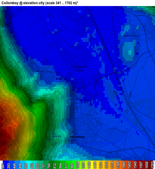
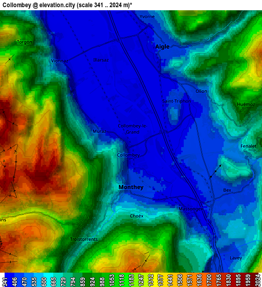
Below is the Elevation map of Collombey, which displays elevation range with different colors. Scale of the first map is from 341 to 1702 m (1119 to 5584 ft) with average elevation of 536 meters (=1759 ft) [note 1]
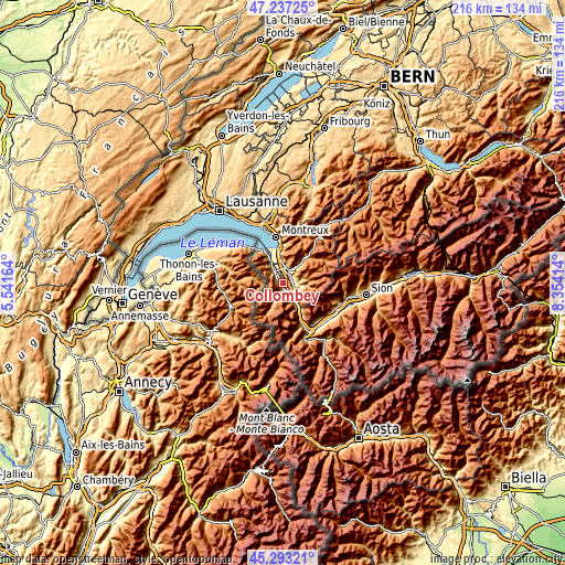
These maps also provides idea of topography and contour of this city, they are displayed at different zoom levels. More info about maps, scale and edge coordinates you can find below images.
| \ | Map #1 | Map #2 | Topo.Map |
| Scale [m] | 341..1702 m | 341..2024 m | × |
| Scale [ft] | 1119..5584 ft | 1119..6640 ft | × |
| Average | 536 m = 1759 ft | 816.7 m = 2679 ft | × |
| Width | 6.75 km = 4.2 mi | 13.51 km = 8.4 mi | 216.2 km = 134.3 mi |
| Height | 6.75 km = 4.2 mi | 13.51 km = 8.4 mi | 216.1 km = 134.3 mi |
| ↑Max Latitude | 46.304217° | 46.334567° | 47.23725° |
| Latitude at center | 46.27385° | 46.27385° | 46.27385° |
| ↓Min Latitude | 46.243466° | 46.213065° | 45.29321° |
| ← Min Longitude | 6.903945° | 6.859999° | 5.54164° |
| Longitude center | 6.94789° | 6.94789° | 6.94789° |
| →Max Longitude | 6.991835° | 7.035781° | 8.35414° |
Nearby cities:
Cities around Collombey sort by population:
• Monthey elevation 413 m
2.2 km,  167°
167°
• Aigle 408 m
5.1 km,  14°
14°
• Ollon 452 m
4.2 km,  55°
55°
• Bex 421 m
5.5 km,  119°
119°
• Troistorrents 786 m
5.6 km,  206°
206°
• Saint-Maurice 419 m
7.5 km,  145°
145°
• Vouvry 399 m
8.4 km,  327°
327°
• Leysin 1262 m
9 km,  32°
32°
• Villars-sur-Ollon 1273 m
8.8 km,  71°
71°
• Vionnaz 395 m
5.5 km,  318°
318°
• Gryon 1152 m
8.6 km,  90°
90°
• Evionnaz 492 m
11.8 km, 150°
Multilingual:
 En español:
Collombey elevación 389 m.
 En France:
Collombey élévation 389 m.
 Auf Deutsch:
Collombey höhe über dem Meeresspiegel ist 389 m.

Sources and notes:
- [note 1] Map square and city borders are not equal. Map elevation data is calculated only from area inside that square.
- [src 1] Elevation data from geonames database provided with same terms of usage.
- [src 2] The elevation map of Collombey is generated using elevation data from NASA's 3 arcsec (90m) resolution SRTM data.
- [src 3] Base (background) map © OpenStreetMap contributors tiles are generated by Geofabrik and OpenTopoMap.
Copyright & License:
This Collombey Elevation Map is licensed under CC BY-SA. You may reuse any part from this page, if you give a proper credit by linking to this URL:
 More info on terms of use page.