Moudon elevation
Moudon (Vaud, Broye-Vully District), Switzerland elevation is 514 meters and Moudon elevation in feet is 1686 ft above sea level [src 1]. Moudon is a populated place (feature code) with elevation that is 34 meters (112 ft) smaller than average city elevation in Switzerland.
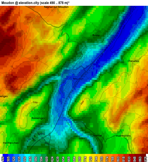
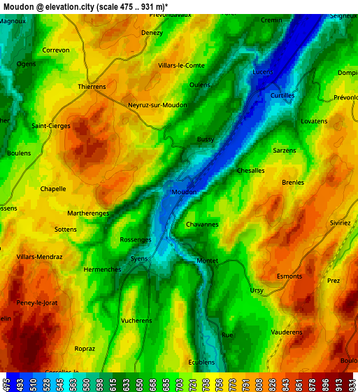
Below is the Elevation map of Moudon, which displays elevation range with different colors. Scale of the first map is from 490 to 878 m (1608 to 2881 ft) with average elevation of 672.8 meters (=2207 ft) [note 1]
These maps also provides idea of topography and contour of this city, they are displayed at different zoom levels. More info about maps, scale and edge coordinates you can find below images.
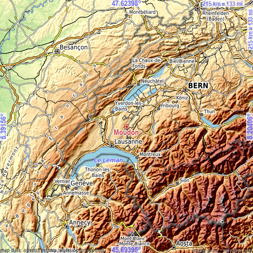
| \ | Map #1 | Map #2 | Topo.Map |
| Scale [m] | 490..878 m | 475..931 m | × |
| Scale [ft] | 1608..2881 ft | 1558..3054 ft | × |
| Average | 672.8 m = 2207 ft | 715.8 m = 2348 ft | × |
| Width | 6.71 km = 4.2 mi | 13.41 km = 8.3 mi | 214.6 km = 133.3 mi |
| Height | 6.71 km = 4.2 mi | 13.41 km = 8.3 mi | 214.6 km = 133.3 mi |
| ↑Max Latitude | 46.697728° | 46.72786° | 47.62398° |
| Latitude at center | 46.66758° | 46.66758° | 46.66758° |
| ↓Min Latitude | 46.637415° | 46.607233° | 45.69395° |
| ← Min Longitude | 6.753865° | 6.709919° | 5.39156° |
| Longitude center | 6.79781° | 6.79781° | 6.79781° |
| →Max Longitude | 6.841755° | 6.885701° | 8.20406° |
Nearby cities:
Cities around Moudon sort by population:
• Ecublens elevation 591 m
6.8 km,  172°
172°
• Romont 763 m
9.8 km,  70°
70°
• Lucens 498 m
5.5 km,  34°
34°
• Rue 662 m
5.7 km,  160°
160°
• Mézières 769 m
9.9 km,  82°
82°
• Pailly 644 m
10.1 km,  291°
291°
• Sottens 754 m
4.5 km,  252°
252°
• Servion 727 m
10.8 km,  187°
187°
• Vuisternens-devant-Romont 801 m
10.2 km,  99°
99°
• Surpierre 476 m
9.9 km, 28°
• Rueyres 617 m
8.6 km, 289°
• Corcelles-le-Jorat 734 m
8 km,  211°
211°
Multilingual:
 En español:
Moudon elevación 514 m.
 En France:
Moudon élévation 514 m.


Sources and notes:
- [note 1] Map square and city borders are not equal. Map elevation data is calculated only from area inside that square.
- [src 1] Elevation data from geonames database provided with same terms of usage.
- [src 2] The elevation map of Moudon is generated using elevation data from NASA's 3 arcsec (90m) resolution SRTM data.
- [src 3] Base (background) map © OpenStreetMap contributors tiles are generated by Geofabrik and OpenTopoMap.
Copyright & License:
This Moudon Elevation Map is licensed under CC BY-SA. You may reuse any part from this page, if you give a proper credit by linking to this URL:
 More info on terms of use page.