Unteriberg elevation
Unteriberg (Schwyz, Bezirk Schwyz), Switzerland elevation is 922 meters and Unteriberg elevation in feet is 3025 ft above sea level [src 1]. Unteriberg is a populated place (feature code) with elevation that is 374 meters (1227 ft) bigger than average city elevation in Switzerland.
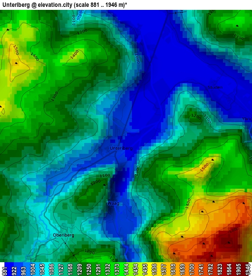
Below is the Elevation map of Unteriberg, which displays elevation range with different colors. Scale of the first map is from 881 to 1946 m (2890 to 6385 ft) with average elevation of 1185.2 meters (=3888 ft) [note 1]
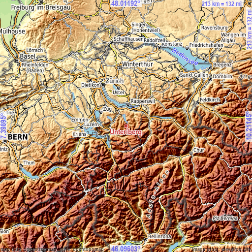
These maps also provides idea of topography and contour of this city, they are displayed at different zoom levels. More info about maps, scale and edge coordinates you can find below images.
| \ | Map #1 | Topo.Map |
| Scale [m] | 881..1946 m | × |
| Scale [ft] | 2890..6385 ft | × |
| Average | 1185.2 m = 3888 ft | × |
| Width | 6.66 km = 4.1 mi | 213 km = 132.4 mi |
| Height | 6.66 km = 4.1 mi | 213 km = 132.4 mi |
| ↑Max Latitude | 47.092507° | 48.01192° |
| Latitude at center | 47.06258° | 47.06258° |
| ↓Min Latitude | 47.032636° | 46.09603° |
| ← Min Longitude | 8.761255° | 7.39895° |
| Longitude center | 8.8052° | 8.8052° |
| →Max Longitude | 8.849145° | 10.21145° |
Nearby cities:
Cities around Unteriberg sort by population:
• Schwyz elevation 521 m
12.4 km,  247°
247°
• Einsiedeln 887 m
8.5 km,  329°
329°
• Siebnen 447 m
14.3 km,  29°
29°
• Altendorf 414 m
14.4 km,  10°
10°
• Feusisberg 696 m
14.5 km,  342°
342°
• Muotathal 640 m
10 km,  197°
197°
• Ibach 454 m
13.4 km,  244°
244°
• Schindellegi 759 m
14.3 km, 330°
• Steinen 477 m
14.7 km,  264°
264°
• Rothenthurm 928 m
10.8 km,  295°
295°
• Sattel 811 m
13 km,  279°
279°
• Vorderthal 746 m
9.9 km,  48°
48°
Multilingual:
 En español:
Unteriberg elevación 922 m.
 En France:
Unteriberg élévation 922 m.
 Auf Deutsch:
Unteriberg höhe über dem Meeresspiegel ist 922 m.

Sources and notes:
- [note 1] Map square and city borders are not equal. Map elevation data is calculated only from area inside that square.
- [src 1] Elevation data from geonames database provided with same terms of usage.
- [src 2] The elevation map of Unteriberg is generated using elevation data from NASA's 3 arcsec (90m) resolution SRTM data.
- [src 3] Base (background) map © OpenStreetMap contributors tiles are generated by Geofabrik and OpenTopoMap.
Copyright & License:
This Unteriberg Elevation Map is licensed under CC BY-SA. You may reuse any part from this page, if you give a proper credit by linking to this URL:
 More info on terms of use page.