Gamboma elevation
Gamboma (Plateaux), Republic of the Congo elevation is 366 meters and Gamboma elevation in feet is 1201 ft above sea level [src 1]. Gamboma is a populated place (feature code) with elevation that is 54 meters (177 ft) bigger than average city elevation in Republic of the Congo.
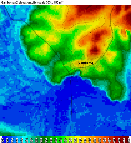
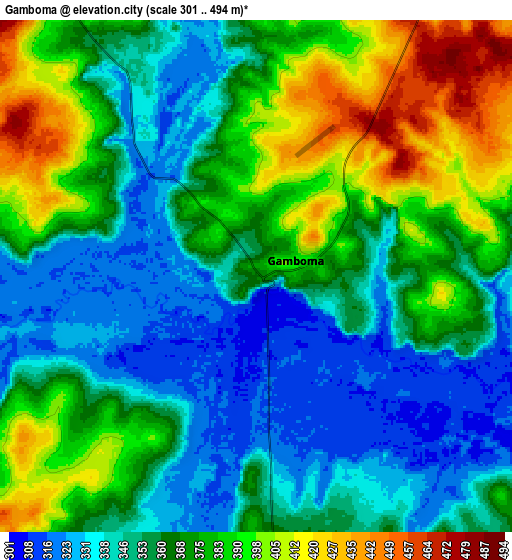
Below is the Elevation map of Gamboma, which displays elevation range with different colors. Scale of the first map is from 303 to 450 m (994 to 1476 ft) with average elevation of 345.4 meters (=1133 ft) [note 1]
These maps also provides idea of topography and contour of this city, they are displayed at different zoom levels. More info about maps, scale and edge coordinates you can find below images.
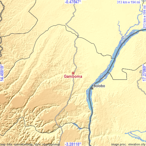
| \ | Map #1 | Map #2 | Topo.Map |
| Scale [m] | 303..450 m | 301..494 m | × |
| Scale [ft] | 994..1476 ft | 988..1621 ft | × |
| Average | 345.4 m = 1133 ft | 364.6 m = 1196 ft | × |
| Width | 9.77 km = 6.1 mi | 19.53 km = 12.1 mi | 312.5 km = 194.2 mi |
| Height | 9.77 km = 6.1 mi | 19.53 km = 12.1 mi | 312.6 km = 194.2 mi |
| ↑Max Latitude | -1.832468° | -1.788544° | -0.47047° |
| Latitude at center | -1.87639° | -1.87639° | -1.87639° |
| ↓Min Latitude | -1.920311° | -1.964231° | -3.28118° |
| ← Min Longitude | 15.820495° | 15.776549° | 14.45819° |
| Longitude center | 15.86444° | 15.86444° | 15.86444° |
| →Max Longitude | 15.908385° | 15.952331° | 17.27069° |
Nearby cities:
Cities around Gamboma sort by population:
• Brazzaville elevation 284 m
273.4 km,  193°
193°
• Kayes 165 m
386 km,  227°
227°
• Owando 355 m
155.1 km,  1°
1°
• Ouésso 348 m
388.6 km, 3°
• Madingou 216 m
360.8 km, 225°
• Sibiti 531 m
343.9 km, 234°
• Mossendjo 448 m
370.8 km,  251°
251°
• Kinkala 426 m
302.1 km,  203°
203°
• Makoua 324 m
211 km,  353°
353°
• Djambala 790 m
144.1 km,  238°
238°
• Ewo 376 m
161 km,  313°
313°
• Nkayi 181 m
384.4 km, 228°
Multilingual:
 En español:
Gamboma elevación 366 m.
 En France:
Gamboma élévation 366 m.


Sources and notes:
- [note 1] Map square and city borders are not equal. Map elevation data is calculated only from area inside that square.
- [src 1] Elevation data from geonames database provided with same terms of usage.
- [src 2] The elevation map of Gamboma is generated using elevation data from NASA's 3 arcsec (90m) resolution SRTM data.
- [src 3] Base (background) map © OpenStreetMap contributors tiles are generated by Geofabrik and OpenTopoMap.
Copyright & License:
This Gamboma Elevation Map is licensed under CC BY-SA. You may reuse any part from this page, if you give a proper credit by linking to this URL:
 More info on terms of use page.