Makoua elevation
Makoua (Cuvette), Republic of the Congo elevation is 324 meters and Makoua elevation in feet is 1063 ft above sea level [src 1]. Makoua is a populated place (feature code) with elevation that is 12 meters (39 ft) bigger than average city elevation in Republic of the Congo.
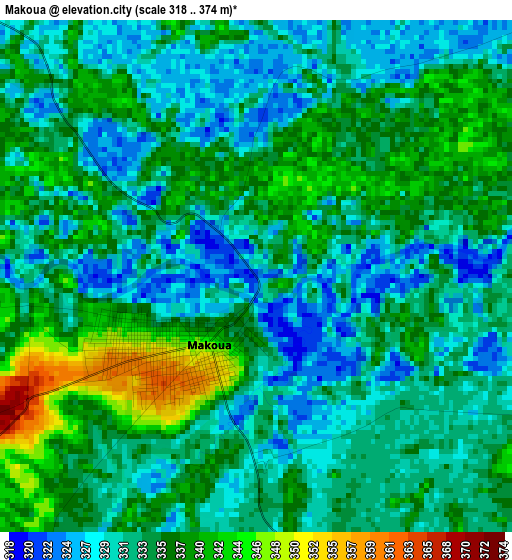
Below is the Elevation map of Makoua, which displays elevation range with different colors. Scale of the first map is from 318 to 374 m (1043 to 1227 ft) with average elevation of 333.6 meters (=1094 ft) [note 1]
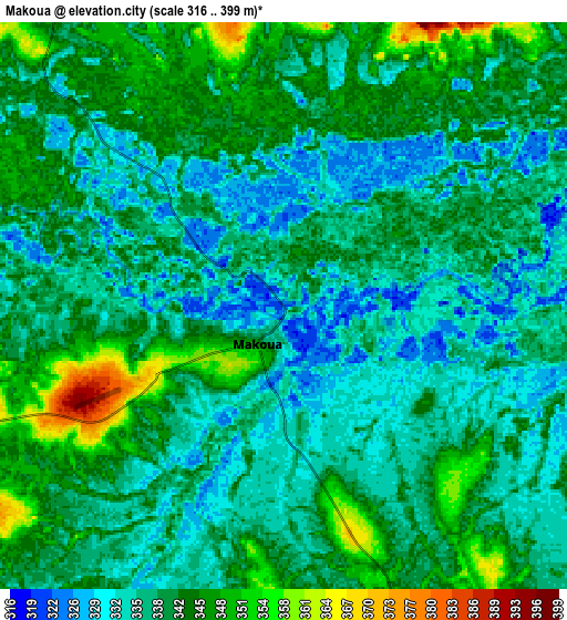
These maps also provides idea of topography and contour of this city, they are displayed at different zoom levels. More info about maps, scale and edge coordinates you can find below images.
| \ | Map #1 | Map #2 | Topo.Map |
| Scale [m] | 318..374 m | 316..399 m | × |
| Scale [ft] | 1043..1227 ft | 1037..1309 ft | × |
| Average | 333.6 m = 1094 ft | 339.1 m = 1113 ft | × |
| Width | 9.77 km = 6.1 mi | 19.55 km = 12.1 mi | 312.7 km = 194.3 mi |
| Height | 9.77 km = 6.1 mi | 19.55 km = 12.1 mi | 312.7 km = 194.3 mi |
| ↑Max Latitude | 0.050885° | 0.094831° | 1.41305° |
| Latitude at center | 0.00694° | 0.00694° | 0.00694° |
| ↓Min Latitude | -0.037005° | -0.080951° | -1.39917° |
| ← Min Longitude | 15.589385° | 15.545439° | 14.22708° |
| Longitude center | 15.63333° | 15.63333° | 15.63333° |
| →Max Longitude | 15.677275° | 15.721221° | 17.03958° |
Nearby cities:
Cities around Makoua sort by population:
• Owando elevation 355 m
61.9 km,  151°
151°
• Ouésso 348 m
184.6 km,  14°
14°
• Gamboma 366 m
211 km,  173°
173°
• Impfondo 323 m
323.8 km,  56°
56°
• Djambala 790 m
300.1 km,  199°
199°
• Ewo 376 m
133.1 km,  222°
222°
• Sémbé 427 m
216.8 km,  327°
327°
Multilingual:
 En español:
Makoua elevación 324 m.
 En France:
Makoua élévation 324 m.


Sources and notes:
- [note 1] Map square and city borders are not equal. Map elevation data is calculated only from area inside that square.
- [src 1] Elevation data from geonames database provided with same terms of usage.
- [src 2] The elevation map of Makoua is generated using elevation data from NASA's 3 arcsec (90m) resolution SRTM data.
- [src 3] Base (background) map © OpenStreetMap contributors tiles are generated by Geofabrik and OpenTopoMap.
Copyright & License:
This Makoua Elevation Map is licensed under CC BY-SA. You may reuse any part from this page, if you give a proper credit by linking to this URL:
 More info on terms of use page.