Madingou elevation
Madingou (Bouenza), Republic of the Congo elevation is 216 meters and Madingou elevation in feet is 709 ft above sea level [src 1]. Madingou is a seat of a first-order administrative division (feature code) with elevation that is 96 meters (315 ft) smaller than average city elevation in Republic of the Congo.
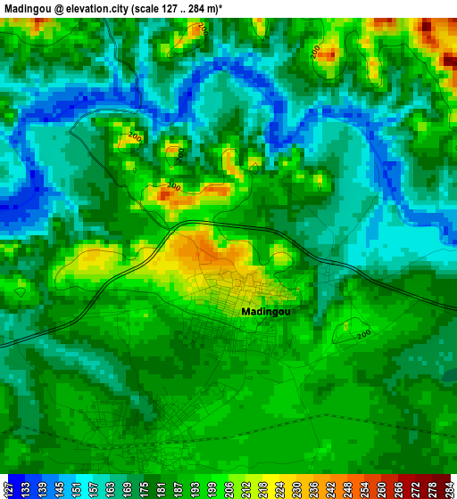
Below is the Elevation map of Madingou, which displays elevation range with different colors. Scale of the first map is from 127 to 284 m (417 to 932 ft) with average elevation of 181.5 meters (=595 ft) [note 1]
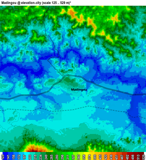
These maps also provides idea of topography and contour of this city, they are displayed at different zoom levels. More info about maps, scale and edge coordinates you can find below images.
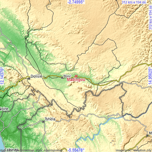
| \ | Map #1 | Map #2 | Topo.Map |
| Scale [m] | 127..284 m | 125..529 m | × |
| Scale [ft] | 417..932 ft | 410..1736 ft | × |
| Average | 181.5 m = 595 ft | 210.6 m = 691 ft | × |
| Width | 9.75 km = 6.1 mi | 19.49 km = 12.1 mi | 311.9 km = 193.8 mi |
| Height | 9.75 km = 6.1 mi | 19.49 km = 12.1 mi | 311.9 km = 193.8 mi |
| ↑Max Latitude | -4.109779° | -4.065945° | -2.74995° |
| Latitude at center | -4.15361° | -4.15361° | -4.15361° |
| ↓Min Latitude | -4.197439° | -4.241265° | -5.55478° |
| ← Min Longitude | 13.506055° | 13.462109° | 12.14375° |
| Longitude center | 13.55° | 13.55° | 13.55° |
| →Max Longitude | 13.593945° | 13.637891° | 14.95625° |
Nearby cities:
Cities around Madingou sort by population:
• Brazzaville elevation 284 m
192.6 km,  93°
93°
• Pointe-Noire 12 m
199.3 km,  249°
249°
• Dolisie 332 m
98.1 km,  267°
267°
• Kayes 165 m
29.8 km,  258°
258°
• Loandjili 7 m
199.2 km, 250°
• Gamboma 366 m
360.8 km,  45°
45°
• Sibiti 531 m
57 km,  337°
337°
• Mossendjo 448 m
163.5 km,  324°
324°
• Kinkala 426 m
136.6 km,  99°
99°
• Djambala 790 m
223.3 km,  36°
36°
• Loango 13 m
200.4 km, 253°
• Nkayi 181 m
29.5 km, 263°
Multilingual:
 En español:
Madingou elevación 216 m.
 En France:
Madingou élévation 216 m.
 Auf Deutsch:
Madingou höhe über dem Meeresspiegel ist 216 m.

Sources and notes:
- [note 1] Map square and city borders are not equal. Map elevation data is calculated only from area inside that square.
- [src 1] Elevation data from geonames database provided with same terms of usage.
- [src 2] The elevation map of Madingou is generated using elevation data from NASA's 3 arcsec (90m) resolution SRTM data.
- [src 3] Base (background) map © OpenStreetMap contributors tiles are generated by Geofabrik and OpenTopoMap.
Copyright & License:
This Madingou Elevation Map is licensed under CC BY-SA. You may reuse any part from this page, if you give a proper credit by linking to this URL:
 More info on terms of use page.