Mongoumba elevation
Mongoumba (Lobaye), Central African Republic elevation is 356 meters and Mongoumba elevation in feet is 1168 ft above sea level [src 1]. Mongoumba is a populated place (feature code) with elevation that is 149 meters (489 ft) smaller than average city elevation in Central African Republic.
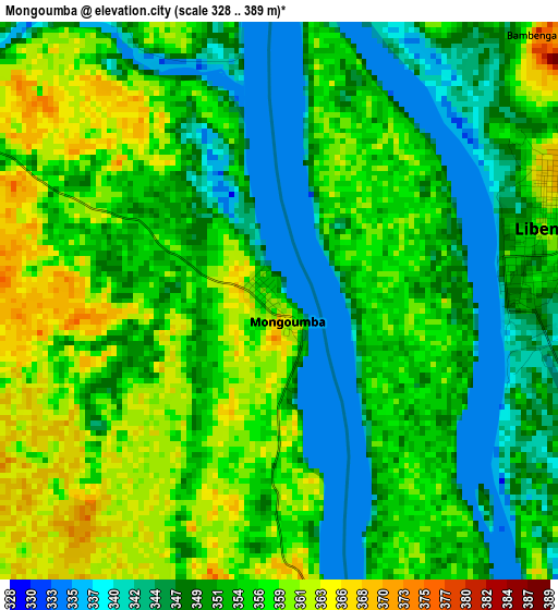
Below is the Elevation map of Mongoumba, which displays elevation range with different colors. Scale of the first map is from 328 to 389 m (1076 to 1276 ft) with average elevation of 353 meters (=1158 ft) [note 1]
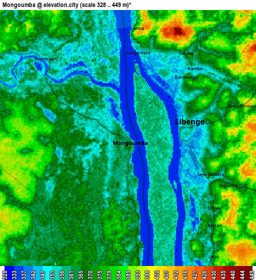
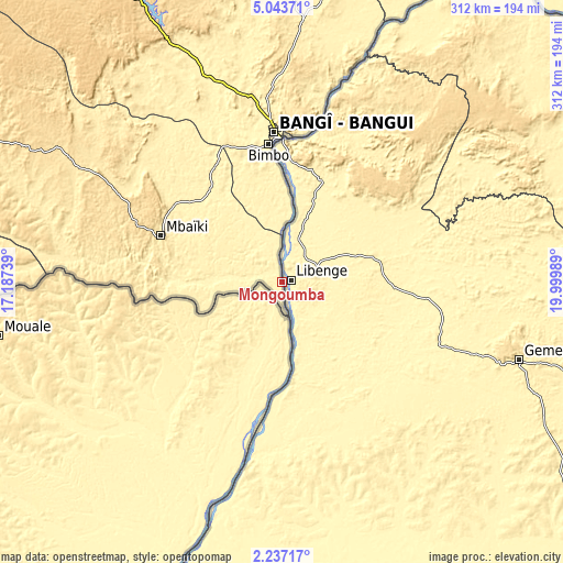
These maps also provides idea of topography and contour of this city, they are displayed at different zoom levels. More info about maps, scale and edge coordinates you can find below images.
| \ | Map #1 | Map #2 | Topo.Map |
| Scale [m] | 328..389 m | 328..449 m | × |
| Scale [ft] | 1076..1276 ft | 1076..1473 ft | × |
| Average | 353 m = 1158 ft | 365.5 m = 1199 ft | × |
| Width | 9.75 km = 6.1 mi | 19.51 km = 12.1 mi | 312.1 km = 193.9 mi |
| Height | 9.75 km = 6.1 mi | 19.51 km = 12.1 mi | 312.1 km = 193.9 mi |
| ↑Max Latitude | 3.685386° | 3.729239° | 5.04371° |
| Latitude at center | 3.64153° | 3.64153° | 3.64153° |
| ↓Min Latitude | 3.597672° | 3.553813° | 2.23717° |
| ← Min Longitude | 18.549695° | 18.505749° | 17.18739° |
| Longitude center | 18.59364° | 18.59364° | 18.59364° |
| →Max Longitude | 18.637585° | 18.681531° | 19.99989° |
Nearby cities:
Cities around Mongoumba sort by population:
• Bangui elevation 351 m
80.1 km,  356°
356°
• Bimbo 371 m
71.2 km,  343°
343°
• Mbaïki 476 m
71.6 km,  290°
290°
• Berbérati 599 m
318.3 km,  282°
282°
• Sibut 431 m
236.9 km,  12°
12°
• Nola 386 m
283 km,  267°
267°
• Damara 415 m
147.2 km,  4°
4°
• Mobaye 388 m
296.5 km,  75°
75°
• Boda 507 m
145.7 km,  301°
301°
• Bouca 463 m
320.6 km,  353°
353°
• Kouango 363 m
213.6 km,  45°
45°
• Boali 379 m
138.8 km, 338°
Multilingual:
 En español:
Mongoumba elevación 356 m.
 En France:
Mongoumba élévation 356 m.
 Auf Deutsch:
Mongoumba höhe über dem Meeresspiegel ist 356 m.

Sources and notes:
- [note 1] Map square and city borders are not equal. Map elevation data is calculated only from area inside that square.
- [src 1] Elevation data from geonames database provided with same terms of usage.
- [src 2] The elevation map of Mongoumba is generated using elevation data from NASA's 3 arcsec (90m) resolution SRTM data.
- [src 3] Base (background) map © OpenStreetMap contributors tiles are generated by Geofabrik and OpenTopoMap.
Copyright & License:
This Mongoumba Elevation Map is licensed under CC BY-SA. You may reuse any part from this page, if you give a proper credit by linking to this URL:
 More info on terms of use page.