Nola elevation
Nola (Sangha-Mbaéré), Central African Republic elevation is 386 meters and Nola elevation in feet is 1266 ft above sea level [src 1]. Nola is a seat of a first-order administrative division (feature code) with elevation that is 119 meters (390 ft) smaller than average city elevation in Central African Republic.
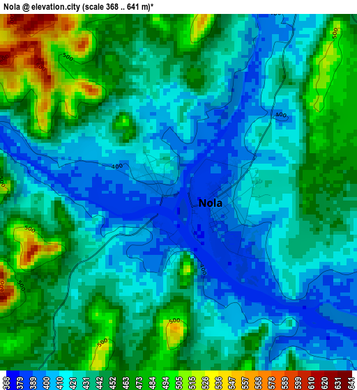
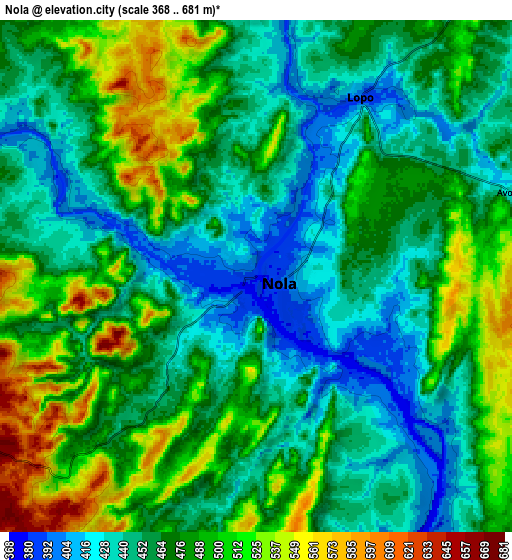
Below is the Elevation map of Nola, which displays elevation range with different colors. Scale of the first map is from 368 to 641 m (1207 to 2103 ft) with average elevation of 437.1 meters (=1434 ft) [note 1]
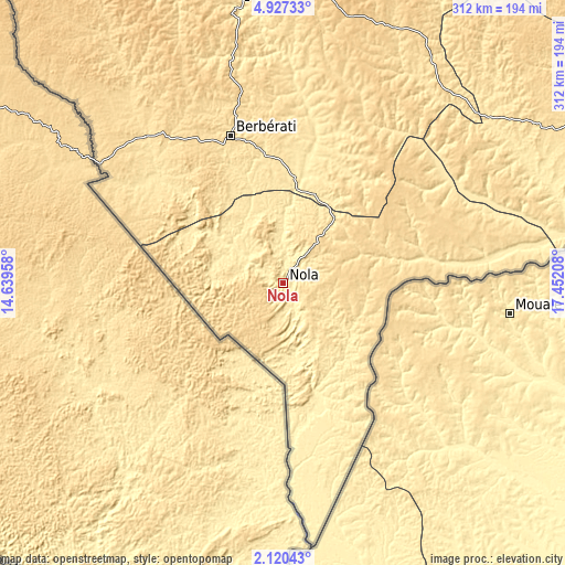
These maps also provides idea of topography and contour of this city, they are displayed at different zoom levels. More info about maps, scale and edge coordinates you can find below images.
| \ | Map #1 | Map #2 | Topo.Map |
| Scale [m] | 368..641 m | 368..681 m | × |
| Scale [ft] | 1207..2103 ft | 1207..2234 ft | × |
| Average | 437.1 m = 1434 ft | 471.3 m = 1546 ft | × |
| Width | 9.75 km = 6.1 mi | 19.51 km = 12.1 mi | 312.1 km = 193.9 mi |
| Height | 9.75 km = 6.1 mi | 19.51 km = 12.1 mi | 312.1 km = 193.9 mi |
| ↑Max Latitude | 3.568801° | 3.61266° | 4.92733° |
| Latitude at center | 3.52494° | 3.52494° | 3.52494° |
| ↓Min Latitude | 3.481077° | 3.437212° | 2.12043° |
| ← Min Longitude | 16.001885° | 15.957939° | 14.63958° |
| Longitude center | 16.04583° | 16.04583° | 16.04583° |
| →Max Longitude | 16.089775° | 16.133721° | 17.45208° |
Nearby cities:
Cities around Nola sort by population:
• Bangui elevation 351 m
293.4 km,  71°
71°
• Bimbo 371 m
275.2 km, 72°
• Mbaïki 476 m
219 km,  79°
79°
• Berbérati 599 m
86.6 km,  341°
341°
• Bozoum 664 m
312.9 km,  6°
6°
• Carnot 551 m
158.7 km,  353°
353°
• Bouar 976 m
272.5 km, 349°
• Boda 507 m
180.9 km,  60°
60°
• Mongoumba 356 m
283 km,  87°
87°
• Gamboula 589 m
120.3 km,  303°
303°
• Baoro 728 m
238.3 km,  357°
357°
• Boali 379 m
270.9 km, 58°
Multilingual:
 En español:
Nola elevación 386 m.
 En France:
Nola élévation 386 m.


Sources and notes:
- [note 1] Map square and city borders are not equal. Map elevation data is calculated only from area inside that square.
- [src 1] Elevation data from geonames database provided with same terms of usage.
- [src 2] The elevation map of Nola is generated using elevation data from NASA's 3 arcsec (90m) resolution SRTM data.
- [src 3] Base (background) map © OpenStreetMap contributors tiles are generated by Geofabrik and OpenTopoMap.
Copyright & License:
This Nola Elevation Map is licensed under CC BY-SA. You may reuse any part from this page, if you give a proper credit by linking to this URL:
 More info on terms of use page.