Gamboula elevation
Gamboula (Mambéré-Kadéï), Central African Republic elevation is 589 meters and Gamboula elevation in feet is 1932 ft above sea level [src 1]. Gamboula is a populated place (feature code) with elevation that is 84 meters (276 ft) bigger than average city elevation in Central African Republic.
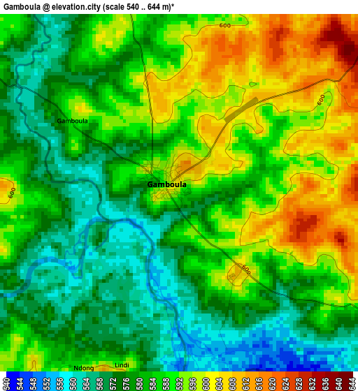
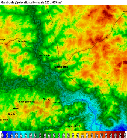
Below is the Elevation map of Gamboula, which displays elevation range with different colors. Scale of the first map is from 540 to 644 m (1772 to 2113 ft) with average elevation of 584.3 meters (=1917 ft) [note 1]
These maps also provides idea of topography and contour of this city, they are displayed at different zoom levels. More info about maps, scale and edge coordinates you can find below images.
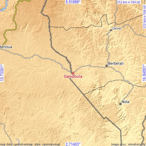
| \ | Map #1 | Map #2 | Topo.Map |
| Scale [m] | 540..644 m | 520..659 m | × |
| Scale [ft] | 1772..2113 ft | 1706..2162 ft | × |
| Average | 584.3 m = 1917 ft | 590 m = 1936 ft | × |
| Width | 9.75 km = 6.1 mi | 19.49 km = 12.1 mi | 311.9 km = 193.8 mi |
| Height | 9.75 km = 6.1 mi | 19.49 km = 12.1 mi | 311.9 km = 193.8 mi |
| ↑Max Latitude | 4.161581° | 4.205409° | 5.51899° |
| Latitude at center | 4.11775° | 4.11775° | 4.11775° |
| ↓Min Latitude | 4.073917° | 4.030081° | 2.71403° |
| ← Min Longitude | 15.095315° | 15.051369° | 13.73301° |
| Longitude center | 15.13926° | 15.13926° | 15.13926° |
| →Max Longitude | 15.183205° | 15.227151° | 16.54551° |
Nearby cities:
Cities around Gamboula sort by population:
• Bimbo elevation 371 m
363.7 km,  87°
87°
• Mbaïki 476 m
317.3 km,  95°
95°
• Berbérati 599 m
74.1 km,  77°
77°
• Bozoum 664 m
280.7 km,  29°
29°
• Carnot 551 m
122.9 km,  41°
41°
• Bouar 976 m
208.2 km,  14°
14°
• Bossangoa 456 m
368.1 km, 44°
• Nola 386 m
120.3 km,  123°
123°
• Paoua 601 m
376.1 km,  22°
22°
• Boda 507 m
259.4 km, 85°
• Baoro 728 m
195.1 km, 28°
• Boali 379 m
339.8 km, 77°
Multilingual:
 En español:
Gamboula elevación 589 m.
 En France:
Gamboula élévation 589 m.
 Auf Deutsch:
Gamboula höhe über dem Meeresspiegel ist 589 m.

Sources and notes:
- [note 1] Map square and city borders are not equal. Map elevation data is calculated only from area inside that square.
- [src 1] Elevation data from geonames database provided with same terms of usage.
- [src 2] The elevation map of Gamboula is generated using elevation data from NASA's 3 arcsec (90m) resolution SRTM data.
- [src 3] Base (background) map © OpenStreetMap contributors tiles are generated by Geofabrik and OpenTopoMap.
Copyright & License:
This Gamboula Elevation Map is licensed under CC BY-SA. You may reuse any part from this page, if you give a proper credit by linking to this URL:
 More info on terms of use page.