Kouango elevation
Kouango (Ouaka), Central African Republic elevation is 363 meters and Kouango elevation in feet is 1191 ft above sea level [src 1]. Kouango is a populated place (feature code) with elevation that is 142 meters (466 ft) smaller than average city elevation in Central African Republic.
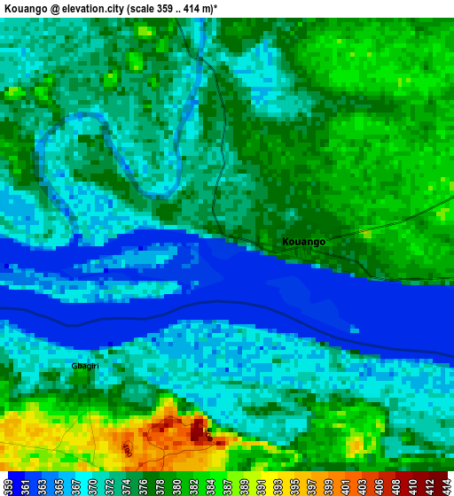
Below is the Elevation map of Kouango, which displays elevation range with different colors. Scale of the first map is from 359 to 414 m (1178 to 1358 ft) with average elevation of 374.3 meters (=1228 ft) [note 1]
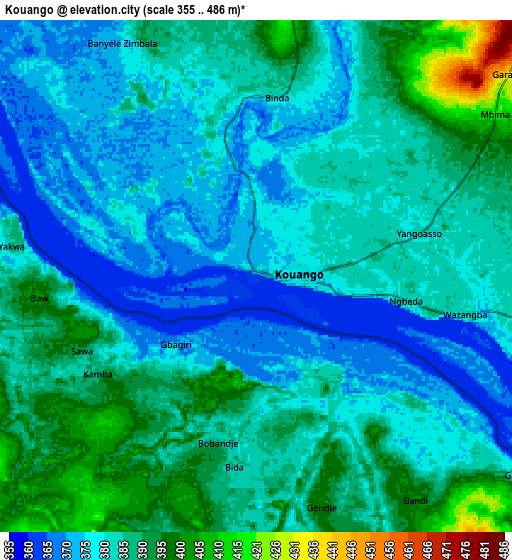
These maps also provides idea of topography and contour of this city, they are displayed at different zoom levels. More info about maps, scale and edge coordinates you can find below images.
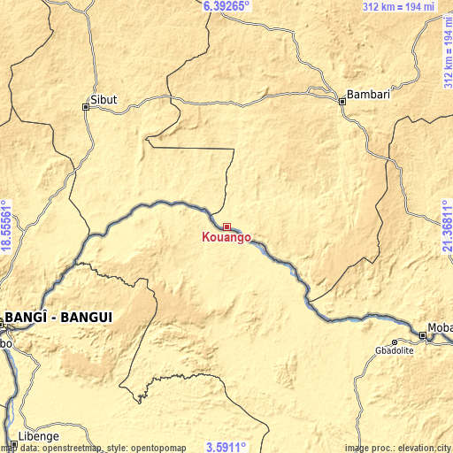
| \ | Map #1 | Map #2 | Topo.Map |
| Scale [m] | 359..414 m | 355..486 m | × |
| Scale [ft] | 1178..1358 ft | 1165..1594 ft | × |
| Average | 374.3 m = 1228 ft | 383.6 m = 1259 ft | × |
| Width | 9.74 km = 6.1 mi | 19.47 km = 12.1 mi | 311.5 km = 193.6 mi |
| Height | 9.74 km = 6.1 mi | 19.47 km = 12.1 mi | 311.5 km = 193.6 mi |
| ↑Max Latitude | 5.037147° | 5.080921° | 6.39265° |
| Latitude at center | 4.99337° | 4.99337° | 4.99337° |
| ↓Min Latitude | 4.94959° | 4.905807° | 3.5911° |
| ← Min Longitude | 19.917915° | 19.873969° | 18.55561° |
| Longitude center | 19.96186° | 19.96186° | 19.96186° |
| →Max Longitude | 20.005805° | 20.049751° | 21.36811° |
Nearby cities:
Cities around Kouango sort by population:
• Bangui elevation 351 m
171 km,  245°
245°
• Bimbo 371 m
189.9 km,  244°
244°
• Kaga Bandoro 416 m
237.9 km,  338°
338°
• Sibut 431 m
127.1 km,  309°
309°
• Bambari 465 m
116.9 km,  42°
42°
• Damara 415 m
139.4 km,  268°
268°
• Mobaye 388 m
154.3 km,  119°
119°
• Ippy 596 m
199 km, 44°
• Alindao 441 m
138.2 km,  88°
88°
• Kembé 499 m
217.2 km,  100°
100°
• Mongoumba 356 m
213.6 km,  225°
225°
• Boali 379 m
204.3 km,  263°
263°
Multilingual:
 En español:
Kouango elevación 363 m.
 En France:
Kouango élévation 363 m.


Sources and notes:
- [note 1] Map square and city borders are not equal. Map elevation data is calculated only from area inside that square.
- [src 1] Elevation data from geonames database provided with same terms of usage.
- [src 2] The elevation map of Kouango is generated using elevation data from NASA's 3 arcsec (90m) resolution SRTM data.
- [src 3] Base (background) map © OpenStreetMap contributors tiles are generated by Geofabrik and OpenTopoMap.
Copyright & License:
This Kouango Elevation Map is licensed under CC BY-SA. You may reuse any part from this page, if you give a proper credit by linking to this URL:
 More info on terms of use page.