Florenceville-Bristol elevation
Florenceville-Bristol (New Brunswick), Canada elevation is 64 meters and Florenceville-Bristol elevation in feet is 210 ft above sea level [src 1]. Florenceville-Bristol is a populated place (feature code) with elevation that is 194 meters (636 ft) smaller than average city elevation in Canada.
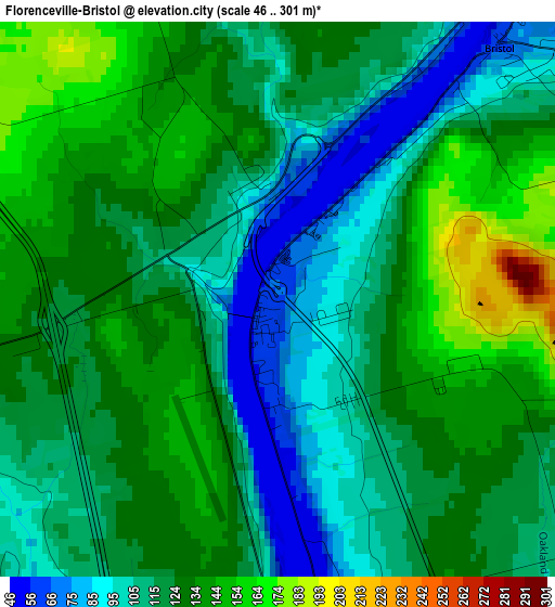
Below is the Elevation map of Florenceville-Bristol, which displays elevation range with different colors. Scale of the first map is from 46 to 301 m (151 to 988 ft) with average elevation of 121.5 meters (=399 ft) [note 1]
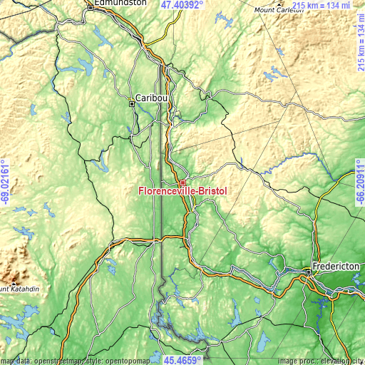
These maps also provides idea of topography and contour of this city, they are displayed at different zoom levels. More info about maps, scale and edge coordinates you can find below images.
| \ | Map #1 | Topo.Map |
| Scale [m] | 46..301 m | × |
| Scale [ft] | 151..988 ft | × |
| Average | 121.5 m = 399 ft | × |
| Width | 6.73 km = 4.2 mi | 215.5 km = 133.9 mi |
| Height | 6.73 km = 4.2 mi | 215.5 km = 133.9 mi |
| ↑Max Latitude | 46.473803° | 47.40392° |
| Latitude at center | 46.44353° | 46.44353° |
| ↓Min Latitude | 46.41324° | 45.4659° |
| ← Min Longitude | -67.659305° | -69.02161° |
| Longitude center | -67.61536° | -67.61536° |
| →Max Longitude | -67.571415° | -66.20911° |
Nearby cities:
Cities around Florenceville-Bristol sort by population:
• Fredericton elevation 110 m
91.7 km,  127°
127°
• Edmundston 154 m
116.6 km,  332°
332°
• Oromocto 27 m
110.6 km, 127°
• Harrison Brook 165 m
88.8 km,  344°
344°
• Saint-Léonard 154 m
83.4 km, 343°
• Lincoln 7 m
99.9 km, 127°
• New Maryland 67 m
96.2 km, 130°
• Starlight Village 92 m
90.2 km, 133°
• Saint Andrews 9 m
158.4 km,  164°
164°
• Keswick Ridge 112 m
74.9 km, 131°
• Noonan 102 m
98.8 km,  122°
122°
• Nackawic 70 m
57.5 km,  149°
149°
Multilingual:
 En español:
Florenceville-Bristol elevación 64 m.
 En France:
Florenceville-Bristol élévation 64 m.
 Auf Deutsch:
Florenceville-Bristol höhe über dem Meeresspiegel ist 64 m.
 На русском:
Florenceville-Bristol высота над уровнем моря 64 м
Sources and notes:
- [note 1] Map square and city borders are not equal. Map elevation data is calculated only from area inside that square.
- [src 1] Elevation data from geonames database provided with same terms of usage.
- [src 2] The elevation map of Florenceville-Bristol is generated using elevation data from NASA's 3 arcsec (90m) resolution SRTM data.
- [src 3] Base (background) map © OpenStreetMap contributors tiles are generated by Geofabrik and OpenTopoMap.
Copyright & License:
This Florenceville-Bristol Elevation Map is licensed under CC BY-SA. You may reuse any part from this page, if you give a proper credit by linking to this URL:
 More info on terms of use page.