Saint-Léonard elevation
Saint-Léonard (New Brunswick, Madawaska County), Canada elevation is 154 meters and Saint-Léonard elevation in feet is 505 ft above sea level [src 1]. Saint-Léonard is a populated place (feature code) with elevation that is 104 meters (341 ft) smaller than average city elevation in Canada.
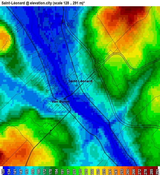
Below is the Elevation map of Saint-Léonard, which displays elevation range with different colors. Scale of the first map is from 128 to 291 m (420 to 955 ft) with average elevation of 178.4 meters (=585 ft) [note 1]
These maps also provides idea of topography and contour of this city, they are displayed at different zoom levels. More info about maps, scale and edge coordinates you can find below images.
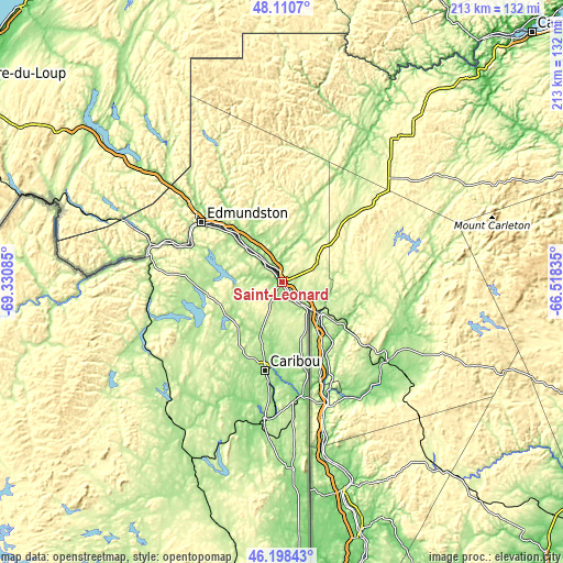
| \ | Map #1 | Topo.Map |
| Scale [m] | 128..291 m | × |
| Scale [ft] | 420..955 ft | × |
| Average | 178.4 m = 585 ft | × |
| Width | 6.64 km = 4.1 mi | 212.6 km = 132.1 mi |
| Height | 6.64 km = 4.1 mi | 212.6 km = 132.1 mi |
| ↑Max Latitude | 47.193041° | 48.1107° |
| Latitude at center | 47.16317° | 47.16317° |
| ↓Min Latitude | 47.133283° | 46.19843° |
| ← Min Longitude | -67.968545° | -69.33085° |
| Longitude center | -67.9246° | -67.9246° |
| →Max Longitude | -67.880655° | -66.51835° |
Nearby cities:
Cities around Saint-Léonard sort by population:
• Rivière-du-Loup elevation 56 m
142.2 km,  301°
301°
• Edmundston 154 m
38.2 km,  307°
307°
• Campbellton 9 m
132.8 km,  45°
45°
• Saint-Pascal 54 m
146.9 km,  285°
285°
• Harrison Brook 165 m
5.6 km,  356°
356°
• Cabano 168 m
92 km, 308°
• Pohénégamook 231 m
103.7 km, 288°
• Cacouna 47 m
144.9 km, 305°
• Florenceville-Bristol 64 m
83.4 km,  163°
163°
• Le Bic 110 m
146.6 km,  336°
336°
• Nackawic 70 m
139.8 km, 158°
• Saint-Antonin 163 m
134.3 km, 299°
Multilingual:
 En español:
Saint-Léonard elevación 154 m.
 En France:
Saint-Léonard élévation 154 m.
 Auf Deutsch:
Saint Leonard höhe über dem Meeresspiegel ist 154 m.

Sources and notes:
- [note 1] Map square and city borders are not equal. Map elevation data is calculated only from area inside that square.
- [src 1] Elevation data from geonames database provided with same terms of usage.
- [src 2] The elevation map of Saint-Léonard is generated using elevation data from NASA's 3 arcsec (90m) resolution SRTM data.
- [src 3] Base (background) map © OpenStreetMap contributors tiles are generated by Geofabrik and OpenTopoMap.
Copyright & License:
This Saint-Léonard Elevation Map is licensed under CC BY-SA. You may reuse any part from this page, if you give a proper credit by linking to this URL:
 More info on terms of use page.