Saint-Joseph-de-Beauce elevation
Saint-Joseph-de-Beauce (Quebec, Chaudière-Appalaches), Canada elevation is 170 meters and Saint-Joseph-de-Beauce elevation in feet is 558 ft above sea level [src 1]. Saint-Joseph-de-Beauce is a populated place (feature code) with elevation that is 88 meters (289 ft) smaller than average city elevation in Canada.
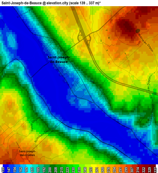
Below is the Elevation map of Saint-Joseph-de-Beauce, which displays elevation range with different colors. Scale of the first map is from 139 to 337 m (456 to 1106 ft) with average elevation of 216.2 meters (=709 ft) [note 1]
These maps also provides idea of topography and contour of this city, they are displayed at different zoom levels. More info about maps, scale and edge coordinates you can find below images.
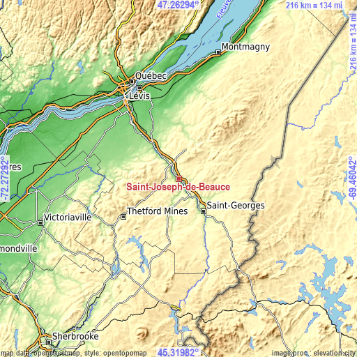
| \ | Map #1 | Map #2 | Topo.Map |
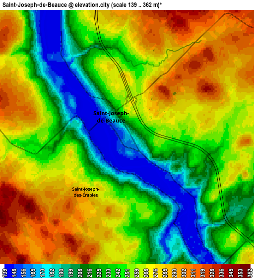
| Scale [m] | 139..337 m | 139..362 m | × |
| Scale [ft] | 456..1106 ft | 456..1188 ft | × |
| Average | 216.2 m = 709 ft | 251.3 m = 824 ft | × |
| Width | 6.75 km = 4.2 mi | 13.5 km = 8.4 mi | 216.1 km = 134.3 mi |
| Height | 6.75 km = 4.2 mi | 13.5 km = 8.4 mi | 216 km = 134.2 mi |
| ↑Max Latitude | 46.330353° | 46.360688° | 47.26294° |
| Latitude at center | 46.3° | 46.3° | 46.3° |
| ↓Min Latitude | 46.269631° | 46.239244° | 45.31982° |
| ← Min Longitude | -70.910615° | -70.954561° | -72.27292° |
| Longitude center | -70.86667° | -70.86667° | -70.86667° |
| →Max Longitude | -70.822725° | -70.778779° | -69.46042° |
Nearby cities:
Cities around Saint-Joseph-de-Beauce sort by population:
• Saint-Georges elevation 163 m
25.9 km,  143°
143°
• Thetford-Mines 317 m
40.8 km,  235°
235°
• Sainte-Marie 159 m
18.6 km,  323°
323°
• Beauceville 174 m
11.4 km, 143°
• Saint-Henri 87 m
46.4 km,  340°
340°
• Adstock 390 m
32.4 km,  210°
210°
• Saint-Anselme 164 m
37.5 km,  347°
347°
• Saint-Lambert-de-Lauzon 131 m
41.2 km, 320°
• Saint-Côme--Linière 310 m
37.4 km,  133°
133°
• Vallée-Jonction 171 m
9.2 km,  334°
334°
• East Broughton 384 m
18.8 km, 239°
• Saint-Éphrem-de-Beauce 294 m
26.7 km,  193°
193°
Multilingual:
 En español:
Saint-Joseph-de-Beauce elevación 170 m.
 En France:
Saint-Joseph-de-Beauce élévation 170 m.
 Auf Deutsch:
Saint-Joseph-de-Beauce höhe über dem Meeresspiegel ist 170 m.
 На русском:
Saint-Joseph-de-Beauce высота над уровнем моря 170 м
Sources and notes:
- [note 1] Map square and city borders are not equal. Map elevation data is calculated only from area inside that square.
- [src 1] Elevation data from geonames database provided with same terms of usage.
- [src 2] The elevation map of Saint-Joseph-de-Beauce is generated using elevation data from NASA's 3 arcsec (90m) resolution SRTM data.
- [src 3] Base (background) map © OpenStreetMap contributors tiles are generated by Geofabrik and OpenTopoMap.
Copyright & License:
This Saint-Joseph-de-Beauce Elevation Map is licensed under CC BY-SA. You may reuse any part from this page, if you give a proper credit by linking to this URL:
 More info on terms of use page.