Saint-Georges elevation
Saint-Georges (Quebec, Chaudière-Appalaches), Canada elevation is 163 meters and Saint-Georges elevation in feet is 535 ft above sea level [src 1]. Saint-Georges is a populated place (feature code) with elevation that is 95 meters (312 ft) smaller than average city elevation in Canada.
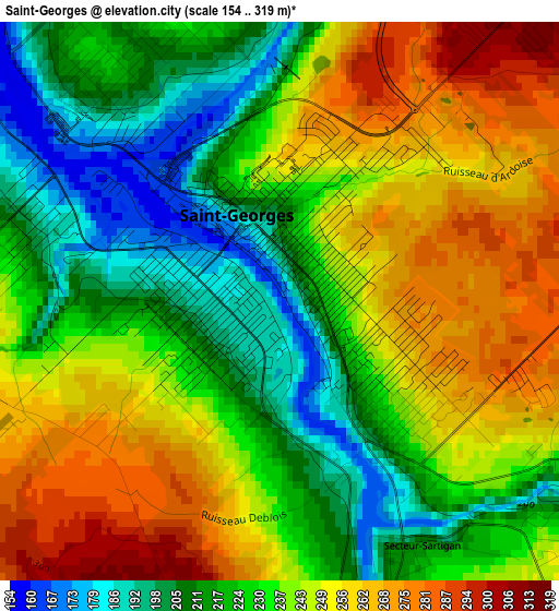
Below is the Elevation map of Saint-Georges, which displays elevation range with different colors. Scale of the first map is from 154 to 319 m (505 to 1047 ft) with average elevation of 236.2 meters (=775 ft) [note 1]
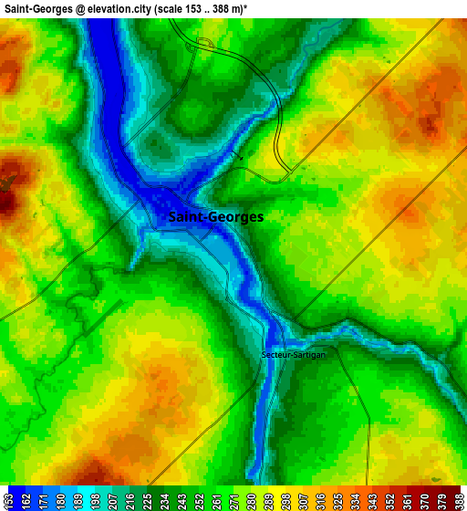
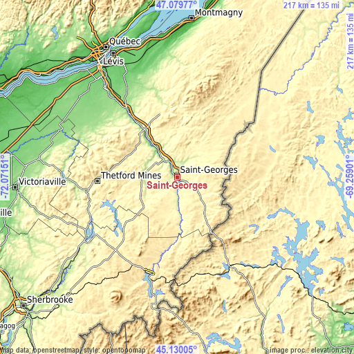
These maps also provides idea of topography and contour of this city, they are displayed at different zoom levels. More info about maps, scale and edge coordinates you can find below images.
| \ | Map #1 | Map #2 | Topo.Map |
| Scale [m] | 154..319 m | 153..388 m | × |
| Scale [ft] | 505..1047 ft | 502..1273 ft | × |
| Average | 236.2 m = 775 ft | 263 m = 863 ft | × |
| Width | 6.77 km = 4.2 mi | 13.55 km = 8.4 mi | 216.8 km = 134.7 mi |
| Height | 6.77 km = 4.2 mi | 13.55 km = 8.4 mi | 216.8 km = 134.7 mi |
| ↑Max Latitude | 46.143986° | 46.174425° | 47.07977° |
| Latitude at center | 46.11353° | 46.11353° | 46.11353° |
| ↓Min Latitude | 46.083057° | 46.052568° | 45.13005° |
| ← Min Longitude | -70.709205° | -70.753151° | -72.07151° |
| Longitude center | -70.66526° | -70.66526° | -70.66526° |
| →Max Longitude | -70.621315° | -70.577369° | -69.25901° |
Nearby cities:
Cities around Saint-Georges sort by population:
• Thetford-Mines elevation 317 m
49.4 km,  267°
267°
• Sainte-Marie 159 m
44.5 km,  323°
323°
• Beauceville 174 m
14.5 km, 323°
• Saint-Joseph-de-Beauce 170 m
25.9 km, 323°
• Adstock 390 m
32.9 km,  257°
257°
• Disraeli 251 m
57.9 km,  245°
245°
• Saint-Côme--Linière 310 m
12.6 km,  114°
114°
• Vallée-Jonction 171 m
35 km,  326°
326°
• East Broughton 384 m
33.6 km,  289°
289°
• Linière 416 m
23 km,  123°
123°
• Saint-Éphrem-de-Beauce 294 m
22.5 km, 256°
• Saint-Joseph-de-Coleraine 273 m
56.5 km, 253°
Multilingual:
 En español:
Saint-Georges elevación 163 m.
 En France:
Saint-Georges élévation 163 m.
 Auf Deutsch:
Saint-Georges höhe über dem Meeresspiegel ist 163 m.

Sources and notes:
- [note 1] Map square and city borders are not equal. Map elevation data is calculated only from area inside that square.
- [src 1] Elevation data from geonames database provided with same terms of usage.
- [src 2] The elevation map of Saint-Georges is generated using elevation data from NASA's 3 arcsec (90m) resolution SRTM data.
- [src 3] Base (background) map © OpenStreetMap contributors tiles are generated by Geofabrik and OpenTopoMap.
Copyright & License:
This Saint-Georges Elevation Map is licensed under CC BY-SA. You may reuse any part from this page, if you give a proper credit by linking to this URL:
 More info on terms of use page.