Windsor elevation
Windsor (Ontario), Canada elevation is 190 meters and Windsor elevation in feet is 623 ft above sea level [src 1]. Windsor is a populated place (feature code) with elevation that is 68 meters (223 ft) smaller than average city elevation in Canada.
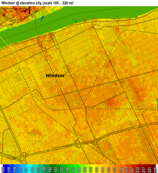
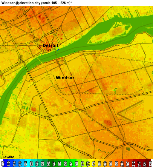
Below is the Elevation map of Windsor, which displays elevation range with different colors. Scale of the first map is from 105 to 226 m (344 to 741 ft) with average elevation of 184.9 meters (=607 ft) [note 1]
These maps also provides idea of topography and contour of this city, they are displayed at different zoom levels. More info about maps, scale and edge coordinates you can find below images.
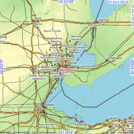
| \ | Map #1 | Map #2 | Topo.Map |
| Scale [m] | 105..226 m | 105..226 m | × |
| Scale [ft] | 344..741 ft | 344..741 ft | × |
| Average | 184.9 m = 607 ft | 183.8 m = 603 ft | × |
| Width | 7.23 km = 4.5 mi | 14.46 km = 9 mi | 231.3 km = 143.7 mi |
| Height | 7.23 km = 4.5 mi | 14.46 km = 9 mi | 231.3 km = 143.7 mi |
| ↑Max Latitude | 42.332575° | 42.365053° | 43.33159° |
| Latitude at center | 42.30008° | 42.30008° | 42.30008° |
| ↓Min Latitude | 42.267568° | 42.23504° | 41.2514° |
| ← Min Longitude | -83.060485° | -83.104431° | -84.42279° |
| Longitude center | -83.01654° | -83.01654° | -83.01654° |
| →Max Longitude | -82.972595° | -82.928649° | -81.61029° |
Nearby cities:
Cities around Windsor sort by population:
• Sarnia elevation 185 m
90.6 km,  33°
33°
• Chatham 183 m
69.5 km,  79°
79°
• Leamington 188 m
44.2 km,  128°
128°
• Amherstburg 181 m
23.3 km,  197°
197°
• Camlachie 200 m
107.6 km,  40°
40°
• Essex 198 m
21 km, 131°
• Corunna 192 m
80.5 km, 36°
• Petrolia 190 m
94.9 km,  48°
48°
• Ridgetown 200 m
92.9 km, 80°
• Glencoe 223 m
117.7 km,  64°
64°
• Walpole Island 176 m
54.1 km, 49°
• Watford 240 m
117.6 km, 52°
Multilingual:
 En español:
Windsor elevación 190 m.
 En France:
Windsor élévation 190 m.


Sources and notes:
- [note 1] Map square and city borders are not equal. Map elevation data is calculated only from area inside that square.
- [src 1] Elevation data from geonames database provided with same terms of usage.
- [src 2] The elevation map of Windsor is generated using elevation data from NASA's 3 arcsec (90m) resolution SRTM data.
- [src 3] Base (background) map © OpenStreetMap contributors tiles are generated by Geofabrik and OpenTopoMap.
Copyright & License:
This Windsor Elevation Map is licensed under CC BY-SA. You may reuse any part from this page, if you give a proper credit by linking to this URL:
 More info on terms of use page.