Camlachie elevation
Camlachie (Ontario), Canada elevation is 200 meters and Camlachie elevation in feet is 656 ft above sea level [src 1]. Camlachie is a populated place (feature code) with elevation that is 58 meters (190 ft) smaller than average city elevation in Canada.
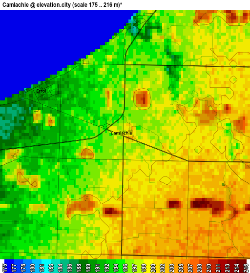
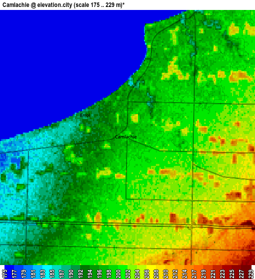
Below is the Elevation map of Camlachie, which displays elevation range with different colors. Scale of the first map is from 175 to 216 m (574 to 709 ft) with average elevation of 195.3 meters (=641 ft) [note 1]
These maps also provides idea of topography and contour of this city, they are displayed at different zoom levels. More info about maps, scale and edge coordinates you can find below images.
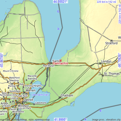
| \ | Map #1 | Map #2 | Topo.Map |
| Scale [m] | 175..216 m | 175..229 m | × |
| Scale [ft] | 574..709 ft | 574..751 ft | × |
| Average | 195.3 m = 641 ft | 194 m = 636 ft | × |
| Width | 7.14 km = 4.4 mi | 14.29 km = 8.9 mi | 228.6 km = 142 mi |
| Height | 7.14 km = 4.4 mi | 14.29 km = 8.9 mi | 228.6 km = 142 mi |
| ↑Max Latitude | 43.068072° | 43.100168° | 44.05521° |
| Latitude at center | 43.03596° | 43.03596° | 43.03596° |
| ↓Min Latitude | 43.003831° | 42.971685° | 41.9995° |
| ← Min Longitude | -82.205545° | -82.249491° | -83.56785° |
| Longitude center | -82.1616° | -82.1616° | -82.1616° |
| →Max Longitude | -82.117655° | -82.073709° | -80.75535° |
Nearby cities:
Cities around Camlachie sort by population:
• Sarnia elevation 185 m
20.7 km,  252°
252°
• Lambton Shores 207 m
23.6 km,  51°
51°
• South Huron 246 m
60.9 km,  59°
59°
• Corunna 192 m
27.9 km,  232°
232°
• Petrolia 190 m
18.8 km,  177°
177°
• Lucan 304 m
64 km,  75°
75°
• Delaware 222 m
62 km,  102°
102°
• Glencoe 223 m
48.2 km,  131°
131°
• Walpole Island 176 m
54.9 km,  211°
211°
• Mount Brydges 246 m
57.2 km,  105°
105°
• Parkhill 207 m
41.1 km,  70°
70°
• Watford 240 m
24.6 km, 112°
Multilingual:
 En español:
Camlachie elevación 200 m.
 En France:
Camlachie élévation 200 m.
 Auf Deutsch:
Camlachie höhe über dem Meeresspiegel ist 200 m.

Sources and notes:
- [note 1] Map square and city borders are not equal. Map elevation data is calculated only from area inside that square.
- [src 1] Elevation data from geonames database provided with same terms of usage.
- [src 2] The elevation map of Camlachie is generated using elevation data from NASA's 3 arcsec (90m) resolution SRTM data.
- [src 3] Base (background) map © OpenStreetMap contributors tiles are generated by Geofabrik and OpenTopoMap.
Copyright & License:
This Camlachie Elevation Map is licensed under CC BY-SA. You may reuse any part from this page, if you give a proper credit by linking to this URL:
 More info on terms of use page.