Welcome Beach elevation
Welcome Beach (British Columbia, Sunshine Coast Regional District), Canada elevation is 81 meters and Welcome Beach elevation in feet is 266 ft above sea level [src 1]. Welcome Beach is a populated locality (feature code) with elevation that is 177 meters (581 ft) smaller than average city elevation in Canada.
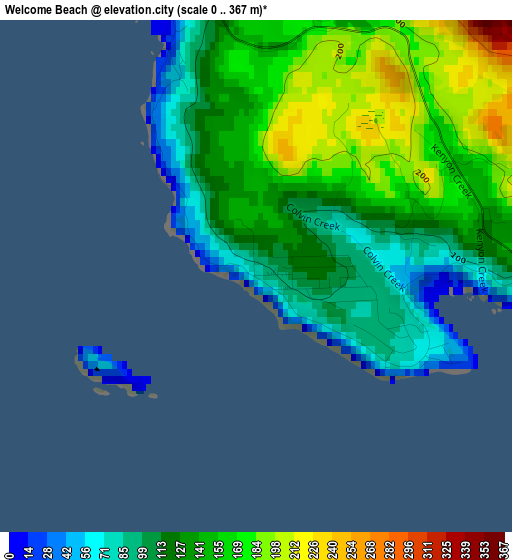
Below is the Elevation map of Welcome Beach, which displays elevation range with different colors. Scale of the first map is from 0 to 367 m (0 to 1204 ft) with average elevation of 138 meters (=453 ft) [note 1]
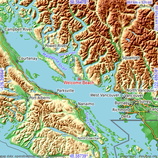
These maps also provides idea of topography and contour of this city, they are displayed at different zoom levels. More info about maps, scale and edge coordinates you can find below images.
| \ | Map #1 | Topo.Map |
| Scale [m] | 0..367 m | × |
| Scale [ft] | 0..1204 ft | × |
| Average | 138 m = 453 ft | × |
| Width | 6.35 km = 3.9 mi | 203.2 km = 126.3 mi |
| Height | 6.35 km = 3.9 mi | 203.2 km = 126.3 mi |
| ↑Max Latitude | 49.508134° | 50.38475° |
| Latitude at center | 49.47959° | 49.47959° |
| ↓Min Latitude | 49.45103° | 48.55739° |
| ← Min Longitude | -123.936335° | -125.29864° |
| Longitude center | -123.89239° | -123.89239° |
| →Max Longitude | -123.848445° | -122.48614° |
Nearby cities:
Cities around Welcome Beach sort by population:
• Nanaimo elevation 16 m
35 km,  185°
185°
• Parksville 26 m
35.4 km,  239°
239°
• Sechelt 10 m
9.6 km,  92°
92°
• Gibsons 16 m
29.5 km,  108°
108°
• Bowen Island 30 m
41.6 km,  104°
104°
• Cedar 32 m
40.5 km,  175°
175°
• Coombs 118 m
43.1 km, 242°
• East Wellington 133 m
35.2 km, 194°
• Lions Bay 66 m
47.4 km, 93°
• South Pender Harbour 65 m
18.5 km,  328°
328°
• Fairwinds 22 m
28.3 km,  216°
216°
• French Creek 31 m
36.9 km,  245°
245°
Multilingual:
 En español:
Welcome Beach elevación 81 m.
 En France:
Welcome Beach élévation 81 m.
 Auf Deutsch:
Welcome Beach höhe über dem Meeresspiegel ist 81 m.

Sources and notes:
- [note 1] Map square and city borders are not equal. Map elevation data is calculated only from area inside that square.
- [src 1] Elevation data from geonames database provided with same terms of usage.
- [src 2] The elevation map of Welcome Beach is generated using elevation data from NASA's 3 arcsec (90m) resolution SRTM data.
- [src 3] Base (background) map © OpenStreetMap contributors tiles are generated by Geofabrik and OpenTopoMap.
Copyright & License:
This Welcome Beach Elevation Map is licensed under CC BY-SA. You may reuse any part from this page, if you give a proper credit by linking to this URL:
 More info on terms of use page.