Swan River elevation
Swan River (Manitoba), Canada elevation is 340 meters and Swan River elevation in feet is 1115 ft above sea level [src 1]. Swan River is a populated place (feature code) with elevation that is 82 meters (269 ft) bigger than average city elevation in Canada.
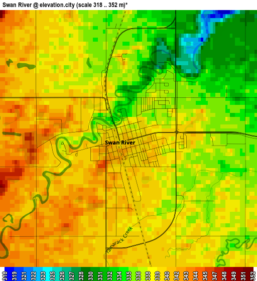
Below is the Elevation map of Swan River, which displays elevation range with different colors. Scale of the first map is from 318 to 352 m (1043 to 1155 ft) with average elevation of 337.9 meters (=1109 ft) [note 1]
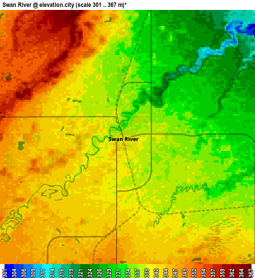
These maps also provides idea of topography and contour of this city, they are displayed at different zoom levels. More info about maps, scale and edge coordinates you can find below images.
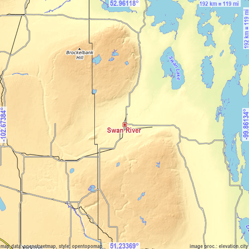
| \ | Map #1 | Map #2 | Topo.Map |
| Scale [m] | 318..352 m | 301..367 m | × |
| Scale [ft] | 1043..1155 ft | 988..1204 ft | × |
| Average | 337.9 m = 1109 ft | 339.7 m = 1115 ft | × |
| Width | 6 km = 3.7 mi | 12 km = 7.5 mi | 192.1 km = 119.4 mi |
| Height | 6 km = 3.7 mi | 12 km = 7.5 mi | 192.1 km = 119.4 mi |
| ↑Max Latitude | 52.132783° | 52.15975° | 52.96118° |
| Latitude at center | 52.1058° | 52.1058° | 52.1058° |
| ↓Min Latitude | 52.0788° | 52.051784° | 51.23369° |
| ← Min Longitude | -101.311535° | -101.355481° | -102.67384° |
| Longitude center | -101.26759° | -101.26759° | -101.26759° |
| →Max Longitude | -101.223645° | -101.179699° | -99.86134° |
Nearby cities:
Cities around Swan River sort by population:
• Yorkton elevation 504 m
128.9 km,  219°
219°
• Dauphin 294 m
135.5 km,  141°
141°
• Melville 549 m
169.5 km, 218°
• Esterhazy 516 m
171.5 km,  199°
199°
• Canora 489 m
95.8 km,  236°
236°
• Roblin 553 m
97.6 km,  183°
183°
• Kamsack 450 m
74.1 km, 215°
• Hudson Bay 375 m
112.1 km,  317°
317°
• Wadena 542 m
174.2 km,  264°
264°
• Foam Lake 552 m
163.6 km,  251°
251°
• Langenburg 511 m
143.1 km,  192°
192°
• Preeceville 508 m
97.3 km, 259°
Multilingual:
 En español:
Swan River elevación 340 m.
 En France:
Swan River élévation 340 m.
 Auf Deutsch:
Swan River höhe über dem Meeresspiegel ist 340 m.

Sources and notes:
- [note 1] Map square and city borders are not equal. Map elevation data is calculated only from area inside that square.
- [src 1] Elevation data from geonames database provided with same terms of usage.
- [src 2] The elevation map of Swan River is generated using elevation data from NASA's 3 arcsec (90m) resolution SRTM data.
- [src 3] Base (background) map © OpenStreetMap contributors tiles are generated by Geofabrik and OpenTopoMap.
Copyright & License:
This Swan River Elevation Map is licensed under CC BY-SA. You may reuse any part from this page, if you give a proper credit by linking to this URL:
 More info on terms of use page.