Melville elevation
Melville (Saskatchewan), Canada elevation is 549 meters and Melville elevation in feet is 1801 ft above sea level [src 1]. Melville is a populated place (feature code) with elevation that is 291 meters (955 ft) bigger than average city elevation in Canada.
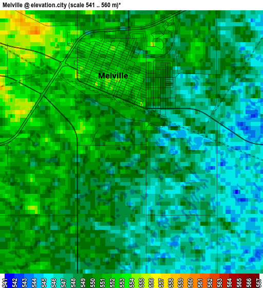
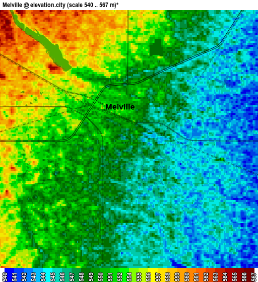
Below is the Elevation map of Melville, which displays elevation range with different colors. Scale of the first map is from 541 to 560 m (1775 to 1837 ft) with average elevation of 548.8 meters (=1801 ft) [note 1]
These maps also provides idea of topography and contour of this city, they are displayed at different zoom levels. More info about maps, scale and edge coordinates you can find below images.
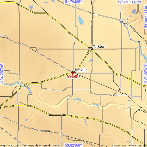
| \ | Map #1 | Map #2 | Topo.Map |
| Scale [m] | 541..560 m | 540..567 m | × |
| Scale [ft] | 1775..1837 ft | 1772..1860 ft | × |
| Average | 548.8 m = 1801 ft | 549.7 m = 1803 ft | × |
| Width | 6.16 km = 3.8 mi | 12.32 km = 7.7 mi | 197.2 km = 122.5 mi |
| Height | 6.16 km = 3.8 mi | 12.32 km = 7.7 mi | 197.1 km = 122.5 mi |
| ↑Max Latitude | 50.944407° | 50.972088° | 51.79485° |
| Latitude at center | 50.91671° | 50.91671° | 50.91671° |
| ↓Min Latitude | 50.888996° | 50.861266° | 50.02168° |
| ← Min Longitude | -102.844935° | -102.888881° | -104.20724° |
| Longitude center | -102.80099° | -102.80099° | -102.80099° |
| →Max Longitude | -102.757045° | -102.713099° | -101.39474° |
Nearby cities:
Cities around Melville sort by population:
• Yorkton elevation 504 m
40.7 km,  34°
34°
• Moosomin 581 m
118.3 km,  137°
137°
• Esterhazy 516 m
58.5 km,  120°
120°
• Canora 489 m
83.7 km,  17°
17°
• Roblin 553 m
106.8 km,  70°
70°
• White City 606 m
122.8 km,  244°
244°
• Kamsack 450 m
95.6 km,  40°
40°
• Pilot Butte 609 m
124.4 km,  246°
246°
• Indian Head 588 m
74.4 km, 235°
• Foam Lake 552 m
96.2 km,  327°
327°
• Langenburg 511 m
76.4 km,  95°
95°
• Preeceville 508 m
115.3 km,  4°
4°
Multilingual:
 En español:
Melville elevación 549 m.
 En France:
Melville élévation 549 m.
 Auf Deutsch:
Melville höhe über dem Meeresspiegel ist 549 m.

Sources and notes:
- [note 1] Map square and city borders are not equal. Map elevation data is calculated only from area inside that square.
- [src 1] Elevation data from geonames database provided with same terms of usage.
- [src 2] The elevation map of Melville is generated using elevation data from NASA's 3 arcsec (90m) resolution SRTM data.
- [src 3] Base (background) map © OpenStreetMap contributors tiles are generated by Geofabrik and OpenTopoMap.
Copyright & License:
This Melville Elevation Map is licensed under CC BY-SA. You may reuse any part from this page, if you give a proper credit by linking to this URL:
 More info on terms of use page.