Saint-Hyacinthe elevation
Saint-Hyacinthe (Quebec, Montérégie), Canada elevation is 32 meters and Saint-Hyacinthe elevation in feet is 105 ft above sea level [src 1]. Saint-Hyacinthe is a populated place (feature code) with elevation that is 226 meters (741 ft) smaller than average city elevation in Canada.
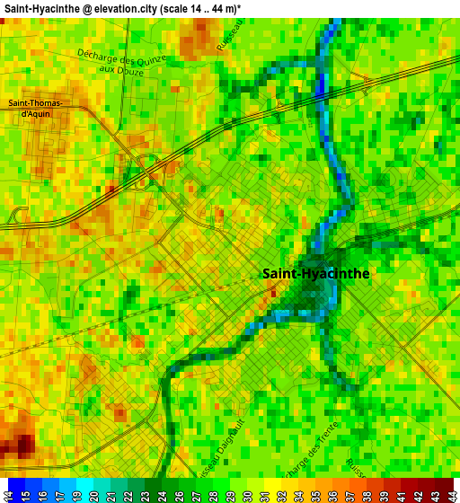
Below is the Elevation map of Saint-Hyacinthe, which displays elevation range with different colors. Scale of the first map is from 14 to 44 m (46 to 144 ft) with average elevation of 30.1 meters (=99 ft) [note 1]
These maps also provides idea of topography and contour of this city, they are displayed at different zoom levels. More info about maps, scale and edge coordinates you can find below images.
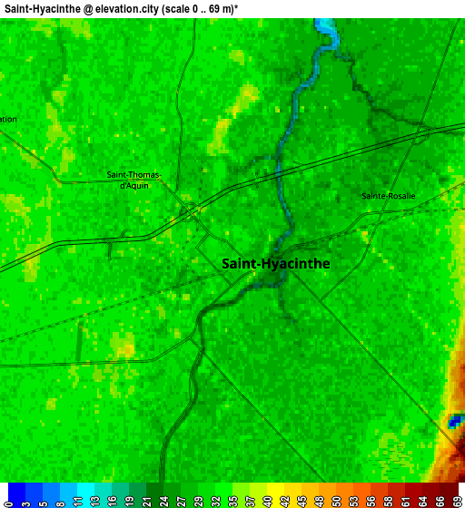
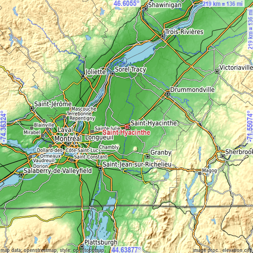
| \ | Map #1 | Map #2 | Topo.Map |
| Scale [m] | 14..44 m | 0..69 m | × |
| Scale [ft] | 46..144 ft | 0..226 ft | × |
| Average | 30.1 m = 99 ft | 30.9 m = 101 ft | × |
| Width | 6.83 km = 4.2 mi | 13.67 km = 8.5 mi | 218.7 km = 135.9 mi |
| Height | 6.83 km = 4.2 mi | 13.67 km = 8.5 mi | 218.7 km = 135.9 mi |
| ↑Max Latitude | 45.661482° | 45.692186° | 46.6055° |
| Latitude at center | 45.63076° | 45.63076° | 45.63076° |
| ↓Min Latitude | 45.600022° | 45.569266° | 44.63877° |
| ← Min Longitude | -73.000935° | -73.044881° | -74.36324° |
| Longitude center | -72.95699° | -72.95699° | -72.95699° |
| →Max Longitude | -72.913045° | -72.869099° | -71.55074° |
Nearby cities:
Cities around Saint-Hyacinthe sort by population:
• Beloeil elevation 13 m
20.6 km,  250°
250°
• Mont-Saint-Hilaire 39 m
19.3 km, 247°
• Saint-Amable 44 m
26.7 km,  274°
274°
• Otterburn Park 13 m
22.9 km,  241°
241°
• Saint-Pie 38 m
14.7 km,  165°
165°
• Saint-Césaire 32 m
24 km,  187°
187°
• Sainte-Madeleine 30 m
11.6 km, 252°
• Saint-Liboire 82 m
15.2 km,  81°
81°
• Rougemont 49 m
23.1 km,  198°
198°
• Saint-Barnabé-Sud 32 m
11.3 km,  13°
13°
• Saint-Damase 30 m
11.3 km, 196°
• Saint-Denis-sur-Richelieu 17 m
22.6 km,  318°
318°
Multilingual:
 En español:
Saint-Hyacinthe elevación 32 m.
 En France:
Saint-Hyacinthe élévation 32 m.
 Auf Deutsch:
Saint-Hyacinthe höhe über dem Meeresspiegel ist 32 m.
 На русском:
Санкт-Гиацинт, Сент-Иасент высота над уровнем моря 32 м
Sources and notes:
- [note 1] Map square and city borders are not equal. Map elevation data is calculated only from area inside that square.
- [src 1] Elevation data from geonames database provided with same terms of usage.
- [src 2] The elevation map of Saint-Hyacinthe is generated using elevation data from NASA's 3 arcsec (90m) resolution SRTM data.
- [src 3] Base (background) map © OpenStreetMap contributors tiles are generated by Geofabrik and OpenTopoMap.
Copyright & License:
This Saint-Hyacinthe Elevation Map is licensed under CC BY-SA. You may reuse any part from this page, if you give a proper credit by linking to this URL:
 More info on terms of use page.