Papineauville elevation
Papineauville (Quebec, Outaouais), Canada elevation is 52 meters and Papineauville elevation in feet is 171 ft above sea level [src 1]. Papineauville is a populated place (feature code) with elevation that is 206 meters (676 ft) smaller than average city elevation in Canada.
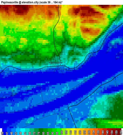
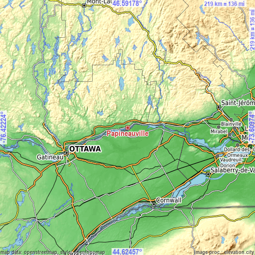
Below is the Elevation map of Papineauville, which displays elevation range with different colors. Scale of the first map is from 36 to 164 m (118 to 538 ft) with average elevation of 70.9 meters (=233 ft) [note 1]
These maps also provides idea of topography and contour of this city, they are displayed at different zoom levels. More info about maps, scale and edge coordinates you can find below images.
| \ | Map #1 | Topo.Map |
| Scale [m] | 36..164 m | × |
| Scale [ft] | 118..538 ft | × |
| Average | 70.9 m = 233 ft | × |
| Width | 6.84 km = 4.3 mi | 218.7 km = 135.9 mi |
| Height | 6.84 km = 4.3 mi | 218.7 km = 135.9 mi |
| ↑Max Latitude | 45.647529° | 46.59178° |
| Latitude at center | 45.6168° | 45.6168° |
| ↓Min Latitude | 45.586054° | 44.62457° |
| ← Min Longitude | -75.059935° | -76.42224° |
| Longitude center | -75.01599° | -75.01599° |
| →Max Longitude | -74.972045° | -73.60974° |
Nearby cities:
Cities around Papineauville sort by population:
• Fallingbrook elevation 78 m
39.7 km,  246°
246°
• Clarence-Rockland 55 m
22.7 km, 250°
• Buckingham 124 m
31.7 km,  263°
263°
• Hawkesbury 53 m
31.2 km,  93°
93°
• Casselman 64 m
33.8 km,  188°
188°
• Thurso 55 m
18.2 km, 264°
• Limoges 68 m
36.4 km,  209°
209°
• Saint-André-Avellin 177 m
11.8 km,  340°
340°
• L'Orignal 52 m
25.2 km, 89°
• Wendover 54 m
10 km,  240°
240°
• Bourget 61 m
22.9 km, 206°
• Plantagenet 51 m
9.5 km,  169°
169°
Multilingual:
 En español:
Papineauville elevación 52 m.
 En France:
Papineauville élévation 52 m.
 Auf Deutsch:
Papineauville höhe über dem Meeresspiegel ist 52 m.

Sources and notes:
- [note 1] Map square and city borders are not equal. Map elevation data is calculated only from area inside that square.
- [src 1] Elevation data from geonames database provided with same terms of usage.
- [src 2] The elevation map of Papineauville is generated using elevation data from NASA's 3 arcsec (90m) resolution SRTM data.
- [src 3] Base (background) map © OpenStreetMap contributors tiles are generated by Geofabrik and OpenTopoMap.
Copyright & License:
This Papineauville Elevation Map is licensed under CC BY-SA. You may reuse any part from this page, if you give a proper credit by linking to this URL:
 More info on terms of use page.