Okanagan Falls elevation
Okanagan Falls (British Columbia), Canada elevation is 357 meters and Okanagan Falls elevation in feet is 1171 ft above sea level [src 1]. Okanagan Falls is a populated place (feature code) with elevation that is 99 meters (325 ft) bigger than average city elevation in Canada.
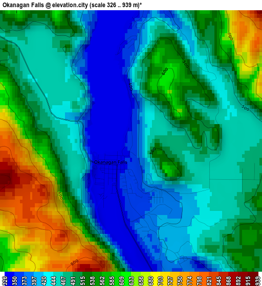
Below is the Elevation map of Okanagan Falls, which displays elevation range with different colors. Scale of the first map is from 326 to 939 m (1070 to 3081 ft) with average elevation of 501.7 meters (=1646 ft) [note 1]
These maps also provides idea of topography and contour of this city, they are displayed at different zoom levels. More info about maps, scale and edge coordinates you can find below images.
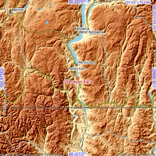
| \ | Map #1 | Topo.Map |
| Scale [m] | 326..939 m | × |
| Scale [ft] | 1070..3081 ft | × |
| Average | 501.7 m = 1646 ft | × |
| Width | 6.37 km = 4 mi | 203.7 km = 126.6 mi |
| Height | 6.37 km = 4 mi | 203.7 km = 126.6 mi |
| ↑Max Latitude | 49.378619° | 50.25757° |
| Latitude at center | 49.35° | 49.35° |
| ↓Min Latitude | 49.321364° | 48.42537° |
| ← Min Longitude | -119.610615° | -120.97292° |
| Longitude center | -119.56667° | -119.56667° |
| →Max Longitude | -119.522725° | -118.16042° |
Nearby cities:
Cities around Okanagan Falls sort by population:
• Kelowna elevation 350 m
59.6 km,  5°
5°
• Vernon 383 m
104.1 km, 11°
• Penticton 357 m
14.6 km,  354°
354°
• West Kelowna 484 m
57 km,  358°
358°
• Duck Lake 432 m
74.3 km, 9°
• Summerland 475 m
28.7 km, 345°
• Oliver 309 m
18.6 km,  176°
176°
• Osoyoos 277 m
36.2 km,  166°
166°
• Grand Forks 514 m
89.4 km,  113°
113°
• Ellison 422 m
66.4 km, 12°
• Princeton 660 m
69.4 km,  279°
279°
• Peachland 342 m
47.9 km, 345°
Multilingual:
 En español:
Okanagan Falls elevación 357 m.
 En France:
Okanagan Falls élévation 357 m.
 Auf Deutsch:
Okanagan Falls höhe über dem Meeresspiegel ist 357 m.

Sources and notes:
- [note 1] Map square and city borders are not equal. Map elevation data is calculated only from area inside that square.
- [src 1] Elevation data from geonames database provided with same terms of usage.
- [src 2] The elevation map of Okanagan Falls is generated using elevation data from NASA's 3 arcsec (90m) resolution SRTM data.
- [src 3] Base (background) map © OpenStreetMap contributors tiles are generated by Geofabrik and OpenTopoMap.
Copyright & License:
This Okanagan Falls Elevation Map is licensed under CC BY-SA. You may reuse any part from this page, if you give a proper credit by linking to this URL:
 More info on terms of use page.