Grand Forks elevation
Grand Forks (British Columbia, Regional District of Kootenay-Boundary), Canada elevation is 514 meters and Grand Forks elevation in feet is 1686 ft above sea level [src 1]. Grand Forks is a populated place (feature code) with elevation that is 256 meters (840 ft) bigger than average city elevation in Canada.
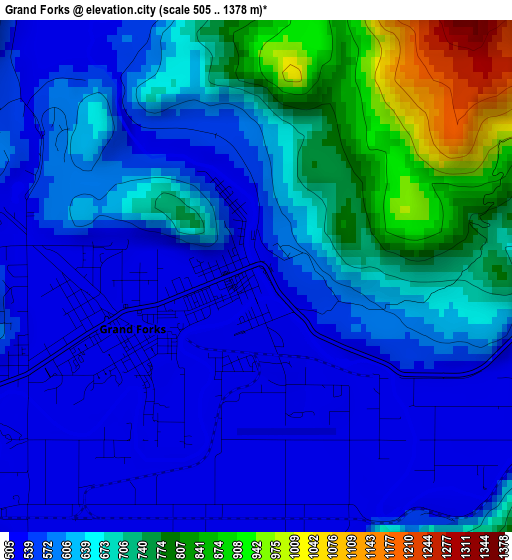
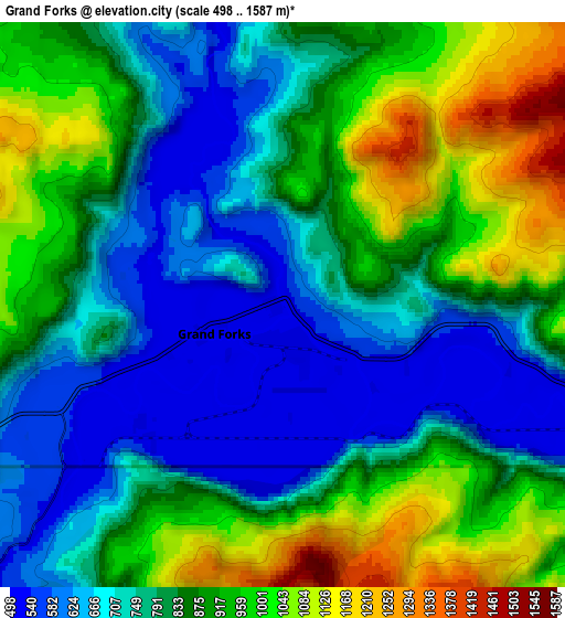
Below is the Elevation map of Grand Forks, which displays elevation range with different colors. Scale of the first map is from 505 to 1378 m (1657 to 4521 ft) with average elevation of 634.9 meters (=2083 ft) [note 1]
These maps also provides idea of topography and contour of this city, they are displayed at different zoom levels. More info about maps, scale and edge coordinates you can find below images.
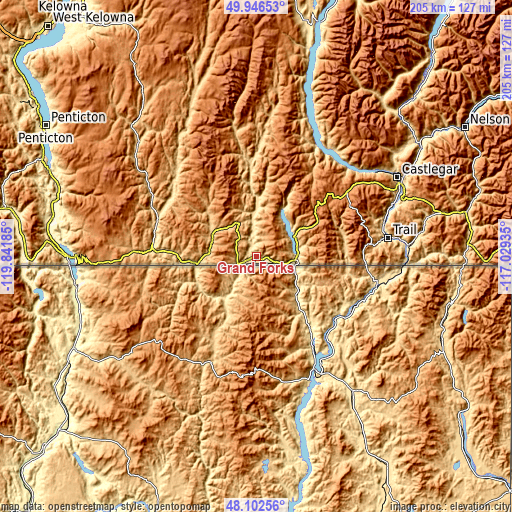
| \ | Map #1 | Map #2 | Topo.Map |
| Scale [m] | 505..1378 m | 498..1587 m | × |
| Scale [ft] | 1657..4521 ft | 1634..5207 ft | × |
| Average | 634.9 m = 2083 ft | 830.8 m = 2726 ft | × |
| Width | 6.41 km = 4 mi | 12.81 km = 8 mi | 205 km = 127.4 mi |
| Height | 6.41 km = 4 mi | 12.81 km = 8 mi | 205 km = 127.4 mi |
| ↑Max Latitude | 49.061893° | 49.09068° | 49.94653° |
| Latitude at center | 49.03309° | 49.03309° | 49.03309° |
| ↓Min Latitude | 49.00427° | 48.975434° | 48.10256° |
| ← Min Longitude | -118.479545° | -118.523491° | -119.84185° |
| Longitude center | -118.4356° | -118.4356° | -118.4356° |
| →Max Longitude | -118.391655° | -118.347709° | -117.02935° |
Nearby cities:
Cities around Grand Forks sort by population:
• Penticton elevation 357 m
97.2 km,  300°
300°
• Nelson 541 m
98.3 km,  58°
58°
• Trail 422 m
53.9 km,  82°
82°
• Castlegar 414 m
65.1 km, 60°
• Summerland 475 m
109.4 km,  305°
305°
• Oliver 309 m
83 km,  281°
281°
• Osoyoos 277 m
74.1 km,  269°
269°
• Fruitvale 659 m
65 km, 81°
• Rossland 1103 m
46.5 km, 83°
• Ellison 422 m
120.7 km,  326°
326°
• Okanagan Falls 357 m
89.4 km,  293°
293°
• Salmo 665 m
86.9 km, 77°
Multilingual:
 En español:
Grand Forks elevación 514 m.
 En France:
Grand Forks élévation 514 m.
 Auf Deutsch:
Grand Forks höhe über dem Meeresspiegel ist 514 m.

Sources and notes:
- [note 1] Map square and city borders are not equal. Map elevation data is calculated only from area inside that square.
- [src 1] Elevation data from geonames database provided with same terms of usage.
- [src 2] The elevation map of Grand Forks is generated using elevation data from NASA's 3 arcsec (90m) resolution SRTM data.
- [src 3] Base (background) map © OpenStreetMap contributors tiles are generated by Geofabrik and OpenTopoMap.
Copyright & License:
This Grand Forks Elevation Map is licensed under CC BY-SA. You may reuse any part from this page, if you give a proper credit by linking to this URL:
 More info on terms of use page.