Leduc elevation
Leduc (Alberta), Canada elevation is 728 meters and Leduc elevation in feet is 2388 ft above sea level [src 1]. Leduc is a populated place (feature code) with elevation that is 470 meters (1542 ft) bigger than average city elevation in Canada.
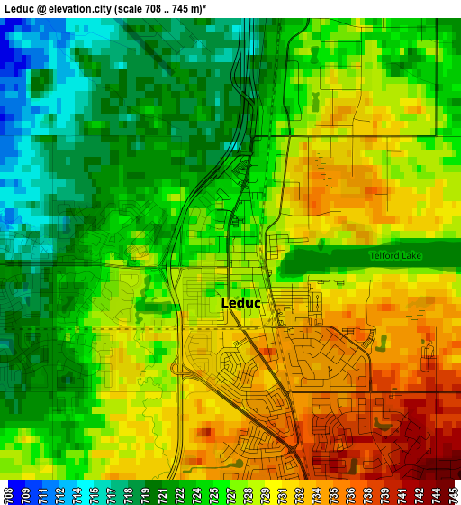
Below is the Elevation map of Leduc, which displays elevation range with different colors. Scale of the first map is from 708 to 745 m (2323 to 2444 ft) with average elevation of 726.8 meters (=2385 ft) [note 1]
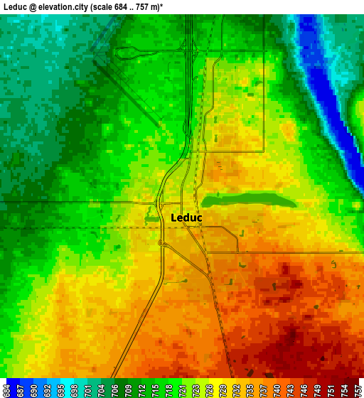
These maps also provides idea of topography and contour of this city, they are displayed at different zoom levels. More info about maps, scale and edge coordinates you can find below images.
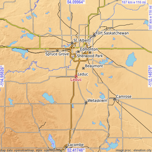
| \ | Map #1 | Map #2 | Topo.Map |
| Scale [m] | 708..745 m | 684..757 m | × |
| Scale [ft] | 2323..2444 ft | 2244..2484 ft | × |
| Average | 726.8 m = 2385 ft | 722.5 m = 2370 ft | × |
| Width | 5.84 km = 3.6 mi | 11.69 km = 7.3 mi | 187 km = 116.2 mi |
| Height | 5.84 km = 3.6 mi | 11.69 km = 7.3 mi | 187 km = 116.2 mi |
| ↑Max Latitude | 53.293095° | 53.319354° | 54.09964° |
| Latitude at center | 53.26682° | 53.26682° | 53.26682° |
| ↓Min Latitude | 53.240529° | 53.214221° | 52.41746° |
| ← Min Longitude | -113.595955° | -113.639901° | -114.95826° |
| Longitude center | -113.55201° | -113.55201° | -113.55201° |
| →Max Longitude | -113.508065° | -113.464119° | -112.14576° |
Nearby cities:
Cities around Leduc sort by population:
• Silver Berry elevation 713 m
24.1 km,  28°
28°
• Wild Rose 714 m
25.4 km, 26°
• Beaumont 716 m
12.8 km,  43°
43°
• Devon 695 m
16.5 km,  312°
312°
• Larkspur 711 m
26.2 km, 25°
• Tamarack 710 m
25.3 km, 29°
• Calmar 725 m
17.7 km,  270°
270°
• Millet 753 m
19.3 km,  163°
163°
• Rideau Park 670 m
23.8 km,  7°
7°
• Maple Ridge 703 m
29 km, 25°
• Laurel 721 m
23 km, 29°
• Mill Woods Town Centre 690 m
22.6 km,  21°
21°
Multilingual:
 En español:
Leduc elevación 728 m.
 En France:
Leduc élévation 728 m.


Sources and notes:
- [note 1] Map square and city borders are not equal. Map elevation data is calculated only from area inside that square.
- [src 1] Elevation data from geonames database provided with same terms of usage.
- [src 2] The elevation map of Leduc is generated using elevation data from NASA's 3 arcsec (90m) resolution SRTM data.
- [src 3] Base (background) map © OpenStreetMap contributors tiles are generated by Geofabrik and OpenTopoMap.
Copyright & License:
This Leduc Elevation Map is licensed under CC BY-SA. You may reuse any part from this page, if you give a proper credit by linking to this URL:
 More info on terms of use page.