Belfast elevation
Belfast (Prince Edward Island), Canada elevation is 14 meters and Belfast elevation in feet is 46 ft above sea level [src 1]. Belfast is a populated locality (feature code) with elevation that is 244 meters (801 ft) smaller than average city elevation in Canada.
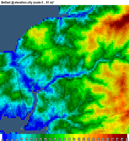
Below is the Elevation map of Belfast, which displays elevation range with different colors. Scale of the first map is from 0 to 81 m (0 to 266 ft) with average elevation of 31.1 meters (=102 ft) [note 1]
These maps also provides idea of topography and contour of this city, they are displayed at different zoom levels. More info about maps, scale and edge coordinates you can find below images.
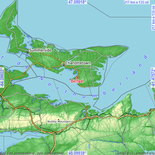
| \ | Map #1 | Topo.Map |
| Scale [m] | 0..81 m | × |
| Scale [ft] | 0..266 ft | × |
| Average | 31.1 m = 102 ft | × |
| Width | 6.78 km = 4.2 mi | 216.9 km = 134.8 mi |
| Height | 6.78 km = 4.2 mi | 216.9 km = 134.8 mi |
| ↑Max Latitude | 46.113883° | 47.05018° |
| Latitude at center | 46.08341° | 46.08341° |
| ↓Min Latitude | 46.052921° | 45.09939° |
| ← Min Longitude | -62.925915° | -64.28822° |
| Longitude center | -62.88197° | -62.88197° |
| →Max Longitude | -62.838025° | -61.47572° |
Nearby cities:
Cities around Belfast sort by population:
• Charlottetown elevation 5 m
26 km,  311°
311°
• Truro 17 m
85.1 km,  200°
200°
• New Glasgow 11 m
58.5 km,  161°
161°
• Summerside 16 m
77.8 km,  296°
296°
• Antigonish 17 m
85.9 km,  127°
127°
• Pictou 45 m
46.9 km, 163°
• Cornwall 15 m
30.4 km, 301°
• Montague 11 m
20.2 km,  62°
62°
• Kensington 33 m
70.6 km, 303°
• Middleton 40 m
46.8 km,  209°
209°
• Souris 8 m
57 km, 58°
• Oxford 6 m
85.5 km,  242°
242°
Multilingual:
 En español:
Belfast elevación 14 m.
 En France:
Belfast élévation 14 m.


Sources and notes:
- [note 1] Map square and city borders are not equal. Map elevation data is calculated only from area inside that square.
- [src 1] Elevation data from geonames database provided with same terms of usage.
- [src 2] The elevation map of Belfast is generated using elevation data from NASA's 3 arcsec (90m) resolution SRTM data.
- [src 3] Base (background) map © OpenStreetMap contributors tiles are generated by Geofabrik and OpenTopoMap.
Copyright & License:
This Belfast Elevation Map is licensed under CC BY-SA. You may reuse any part from this page, if you give a proper credit by linking to this URL:
 More info on terms of use page.