Antigonish elevation
Antigonish (Nova Scotia), Canada elevation is 17 meters and Antigonish elevation in feet is 56 ft above sea level [src 1]. Antigonish is a populated place (feature code) with elevation that is 241 meters (791 ft) smaller than average city elevation in Canada.
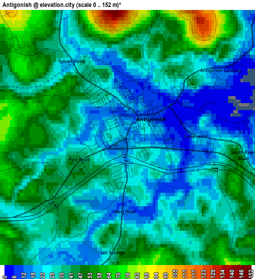
Below is the Elevation map of Antigonish, which displays elevation range with different colors. Scale of the first map is from 0 to 152 m (0 to 499 ft) with average elevation of 36.7 meters (=120 ft) [note 1]
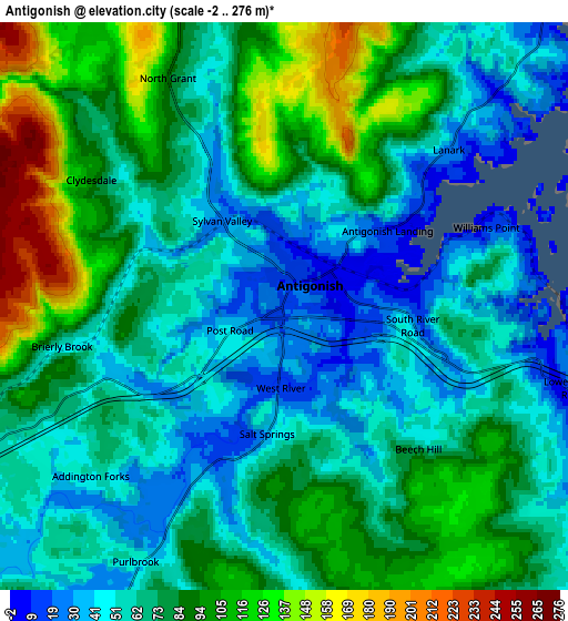
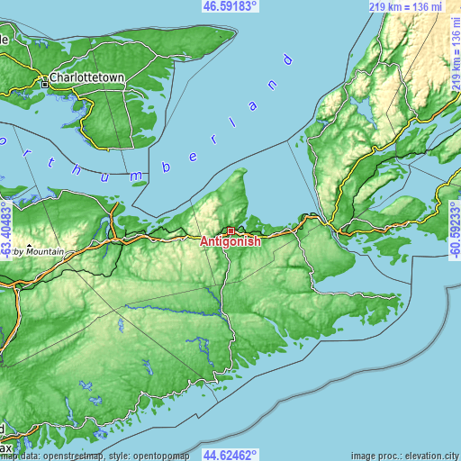
These maps also provides idea of topography and contour of this city, they are displayed at different zoom levels. More info about maps, scale and edge coordinates you can find below images.
| \ | Map #1 | Map #2 | Topo.Map |
| Scale [m] | 0..152 m | -2..276 m | × |
| Scale [ft] | 0..499 ft | -7..906 ft | × |
| Average | 36.7 m = 120 ft | 74.1 m = 243 ft | × |
| Width | 6.84 km = 4.3 mi | 13.67 km = 8.5 mi | 218.7 km = 135.9 mi |
| Height | 6.84 km = 4.3 mi | 13.67 km = 8.5 mi | 218.7 km = 135.9 mi |
| ↑Max Latitude | 45.647579° | 45.678292° | 46.59183° |
| Latitude at center | 45.61685° | 45.61685° | 45.61685° |
| ↓Min Latitude | 45.586104° | 45.555341° | 44.62462° |
| ← Min Longitude | -62.042525° | -62.086471° | -63.40483° |
| Longitude center | -61.99858° | -61.99858° | -61.99858° |
| →Max Longitude | -61.954635° | -61.910689° | -60.59233° |
Nearby cities:
Cities around Antigonish sort by population:
• Charlottetown elevation 5 m
111.8 km,  308°
308°
• Truro 17 m
102.6 km,  254°
254°
• New Glasgow 11 m
50.7 km,  265°
265°
• Princeville 43 m
56.9 km,  72°
72°
• Pictou 45 m
55.7 km,  277°
277°
• Port Hawkesbury 42 m
50.6 km,  90°
90°
• Cornwall 15 m
116.2 km, 305°
• Eskasoni 3 12 m
113.2 km, 71°
• Belfast 14 m
85.9 km, 307°
• Montague 11 m
79.2 km,  320°
320°
• Middleton 40 m
92.4 km, 276°
• Souris 8 m
83.8 km,  346°
346°
Multilingual:
 En español:
Antigonish elevación 17 m.
 En France:
Antigonish élévation 17 m.
 Auf Deutsch:
Antigonish höhe über dem Meeresspiegel ist 17 m.

Sources and notes:
- [note 1] Map square and city borders are not equal. Map elevation data is calculated only from area inside that square.
- [src 1] Elevation data from geonames database provided with same terms of usage.
- [src 2] The elevation map of Antigonish is generated using elevation data from NASA's 3 arcsec (90m) resolution SRTM data.
- [src 3] Base (background) map © OpenStreetMap contributors tiles are generated by Geofabrik and OpenTopoMap.
Copyright & License:
This Antigonish Elevation Map is licensed under CC BY-SA. You may reuse any part from this page, if you give a proper credit by linking to this URL:
 More info on terms of use page.