Novogrudok elevation
Novogrudok (Grodnenskaya), Belarus elevation is 309 meters and Novogrudok elevation in feet is 1014 ft above sea level [src 1]. Novogrudok is a populated place (feature code) with elevation that is 142 meters (466 ft) bigger than average city elevation in Belarus.
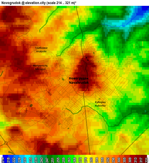
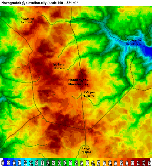
Below is the Elevation map of Novogrudok, which displays elevation range with different colors. Scale of the first map is from 214 to 321 m (702 to 1053 ft) with average elevation of 283.9 meters (=931 ft) [note 1]
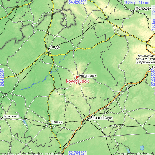
These maps also provides idea of topography and contour of this city, they are displayed at different zoom levels. More info about maps, scale and edge coordinates you can find below images.
| \ | Map #1 | Map #2 | Topo.Map |
| Scale [m] | 214..321 m | 190..321 m | × |
| Scale [ft] | 702..1053 ft | 623..1053 ft | × |
| Average | 283.9 m = 931 ft | 271 m = 889 ft | × |
| Width | 5.8 km = 3.6 mi | 11.6 km = 7.2 mi | 185.6 km = 115.3 mi |
| Height | 5.8 km = 3.6 mi | 11.6 km = 7.2 mi | 185.6 km = 115.3 mi |
| ↑Max Latitude | 53.620274° | 53.646331° | 54.42059° |
| Latitude at center | 53.5942° | 53.5942° | 53.5942° |
| ↓Min Latitude | 53.56811° | 53.542005° | 52.75132° |
| ← Min Longitude | 25.775155° | 25.731209° | 24.41285° |
| Longitude center | 25.8191° | 25.8191° | 25.8191° |
| →Max Longitude | 25.863045° | 25.906991° | 27.22535° |
Nearby cities:
Cities around Novogrudok sort by population:
• Baranovichi elevation 199 m
52.9 km,  165°
165°
• Lida 144 m
46.9 km,  313°
313°
• Byarozawka 140 m
25.7 km,  304°
304°
• Iwye 145 m
37.5 km,  355°
355°
• Dyatlovo 163 m
30.9 km,  241°
241°
• Karelichy 149 m
21.5 km,  98°
98°
• Haradzyeya 180 m
57 km,  123°
123°
• Snow 187 m
56.7 km,  137°
137°
• Haradzishcha 201 m
32.5 km,  157°
157°
• Mir 170 m
45.6 km,  109°
109°
• Lyubcha 139 m
23.7 km,  42°
42°
• Zhaludok 134 m
55.2 km,  270°
270°
Multilingual:
 En español:
Novogrudok elevación 309 m.
 En France:
Navahroudak élévation 309 m.
 Auf Deutsch:
Nawahradak höhe über dem Meeresspiegel ist 309 m.

Sources and notes:
- [note 1] Map square and city borders are not equal. Map elevation data is calculated only from area inside that square.
- [src 1] Elevation data from geonames database provided with same terms of usage.
- [src 2] The elevation map of Novogrudok is generated using elevation data from NASA's 3 arcsec (90m) resolution SRTM data.
- [src 3] Base (background) map © OpenStreetMap contributors tiles are generated by Geofabrik and OpenTopoMap.
Copyright & License:
This Novogrudok Elevation Map is licensed under CC BY-SA. You may reuse any part from this page, if you give a proper credit by linking to this URL:
 More info on terms of use page.