Byarozawka elevation
Byarozawka (Grodnenskaya), Belarus elevation is 140 meters and Byarozawka elevation in feet is 459 ft above sea level [src 1]. Byarozawka is a populated place (feature code) with elevation that is 27 meters (89 ft) smaller than average city elevation in Belarus.
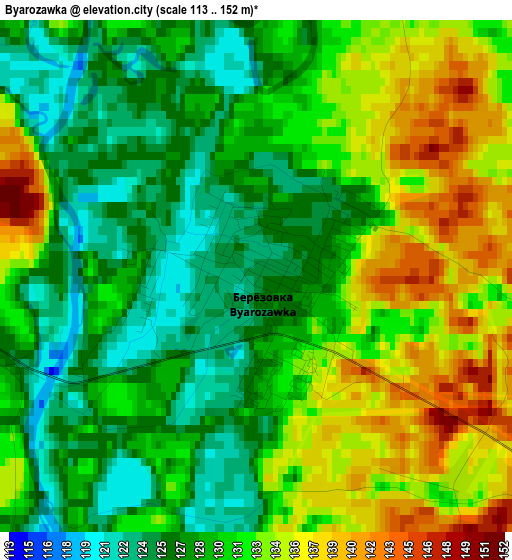
Below is the Elevation map of Byarozawka, which displays elevation range with different colors. Scale of the first map is from 113 to 152 m (371 to 499 ft) with average elevation of 130.1 meters (=427 ft) [note 1]
These maps also provides idea of topography and contour of this city, they are displayed at different zoom levels. More info about maps, scale and edge coordinates you can find below images.
| \ | Map #1 | Map #2 | Topo.Map |
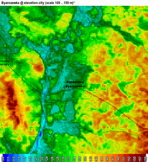
| Scale [m] | 113..152 m | 109..159 m | × |
| Scale [ft] | 371..499 ft | 358..522 ft | × |
| Average | 130.1 m = 427 ft | 133.7 m = 439 ft | × |
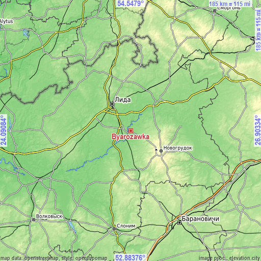
| Width | 5.78 km = 3.6 mi | 11.56 km = 7.2 mi | 185 km = 115 mi |
| Height | 5.78 km = 3.6 mi | 11.56 km = 7.2 mi | 185 km = 115 mi |
| ↑Max Latitude | 53.750053° | 53.776031° | 54.5479° |
| Latitude at center | 53.72406° | 53.72406° | 53.72406° |
| ↓Min Latitude | 53.698051° | 53.672025° | 52.88376° |
| ← Min Longitude | 25.453145° | 25.409199° | 24.09084° |
| Longitude center | 25.49709° | 25.49709° | 25.49709° |
| →Max Longitude | 25.541035° | 25.584981° | 26.90334° |
Nearby cities:
Cities around Byarozawka sort by population:
• Lida elevation 144 m
21.9 km,  323°
323°
• Novogrudok 309 m
25.7 km,  124°
124°
• Shchuchyn 176 m
51.3 km,  254°
254°
• Iwye 145 m
29.2 km,  38°
38°
• Dyatlovo 163 m
29.6 km,  191°
191°
• Karelichy 149 m
46 km,  112°
112°
• Voranava 172 m
48.8 km,  345°
345°
• Hal’shany 202 m
68.4 km,  29°
29°
• Haradzishcha 201 m
55.9 km,  142°
142°
• Hyeranyony 183 m
43.9 km,  6°
6°
• Lyubcha 139 m
37.2 km,  85°
85°
• Zhaludok 134 m
36.7 km, 247°
Multilingual:
 En español:
Byarozawka elevación 140 m.
 En France:
Byarozawka élévation 140 m.
 Auf Deutsch:
Byarozawka höhe über dem Meeresspiegel ist 140 m.

Sources and notes:
- [note 1] Map square and city borders are not equal. Map elevation data is calculated only from area inside that square.
- [src 1] Elevation data from geonames database provided with same terms of usage.
- [src 2] The elevation map of Byarozawka is generated using elevation data from NASA's 3 arcsec (90m) resolution SRTM data.
- [src 3] Base (background) map © OpenStreetMap contributors tiles are generated by Geofabrik and OpenTopoMap.
Copyright & License:
This Byarozawka Elevation Map is licensed under CC BY-SA. You may reuse any part from this page, if you give a proper credit by linking to this URL:
 More info on terms of use page.