Mir elevation
Mir (Grodnenskaya), Belarus elevation is 170 meters and Mir elevation in feet is 558 ft above sea level [src 1]. Mir is a populated place (feature code) with elevation that is 3 meters (10 ft) bigger than average city elevation in Belarus.
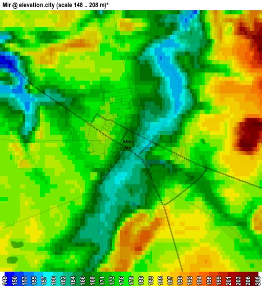
Below is the Elevation map of Mir, which displays elevation range with different colors. Scale of the first map is from 148 to 208 m (486 to 682 ft) with average elevation of 176.5 meters (=579 ft) [note 1]
These maps also provides idea of topography and contour of this city, they are displayed at different zoom levels. More info about maps, scale and edge coordinates you can find below images.
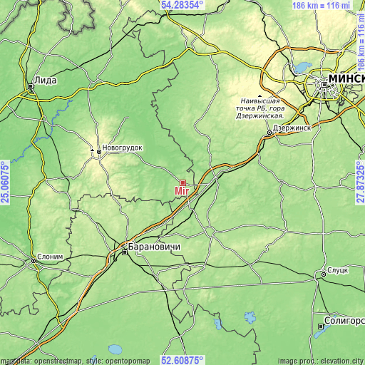
| \ | Map #1 | Topo.Map |
| Scale [m] | 148..208 m | × |
| Scale [ft] | 486..682 ft | × |
| Average | 176.5 m = 579 ft | × |
| Width | 5.82 km = 3.6 mi | 186.2 km = 115.7 mi |
| Height | 5.82 km = 3.6 mi | 186.2 km = 115.7 mi |
| ↑Max Latitude | 53.48056° | 54.28354° |
| Latitude at center | 53.4544° | 53.4544° |
| ↓Min Latitude | 53.428224° | 52.60875° |
| ← Min Longitude | 26.423055° | 25.06075° |
| Longitude center | 26.467° | 26.467° |
| →Max Longitude | 26.510945° | 27.87325° |
Nearby cities:
Cities around Mir sort by population:
• Baranovichi elevation 199 m
46.8 km,  220°
220°
• Novogrudok 309 m
45.6 km,  289°
289°
• Stowbtsy 164 m
18.5 km,  81°
81°
• Nyasvizh 182 m
29.7 km,  151°
151°
• Klyetsk 181 m
44.8 km,  165°
165°
• Karelichy 149 m
24.8 km,  299°
299°
• Haradzyeya 180 m
16.5 km,  163°
163°
• Haradzishcha 201 m
33.5 km,  244°
244°
• Snow 187 m
26.4 km,  189°
189°
• Enyerhyetykaw 183 m
41.5 km,  69°
69°
• Novy Svyerzhan’ 148 m
17.4 km,  90°
90°
• Lyubcha 139 m
42.6 km,  320°
320°
Multilingual:
 En español:
Mir elevación 170 m.
 En France:
Mir élévation 170 m.


Sources and notes:
- [note 1] Map square and city borders are not equal. Map elevation data is calculated only from area inside that square.
- [src 1] Elevation data from geonames database provided with same terms of usage.
- [src 2] The elevation map of Mir is generated using elevation data from NASA's 3 arcsec (90m) resolution SRTM data.
- [src 3] Base (background) map © OpenStreetMap contributors tiles are generated by Geofabrik and OpenTopoMap.
Copyright & License:
This Mir Elevation Map is licensed under CC BY-SA. You may reuse any part from this page, if you give a proper credit by linking to this URL:
 More info on terms of use page.