Ushachy elevation
Ushachy (Vitebsk, Ushatski Rayon), Belarus elevation is 148 meters and Ushachy elevation in feet is 486 ft above sea level [src 1]. Ushachy is a populated place (feature code) with elevation that is 19 meters (62 ft) smaller than average city elevation in Belarus.
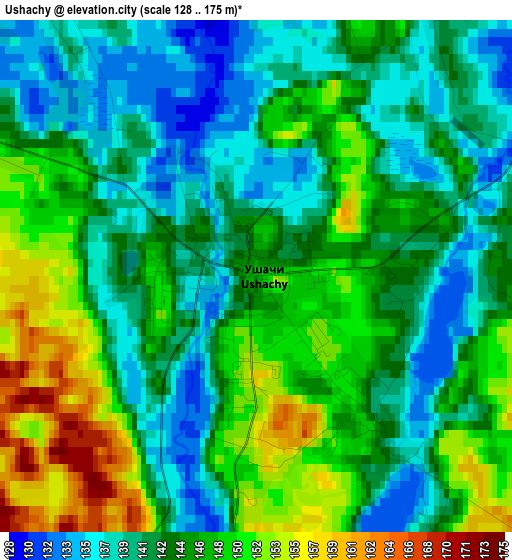
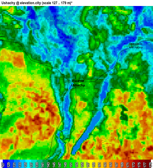
Below is the Elevation map of Ushachy, which displays elevation range with different colors. Scale of the first map is from 128 to 175 m (420 to 574 ft) with average elevation of 144.3 meters (=473 ft) [note 1]
These maps also provides idea of topography and contour of this city, they are displayed at different zoom levels. More info about maps, scale and edge coordinates you can find below images.
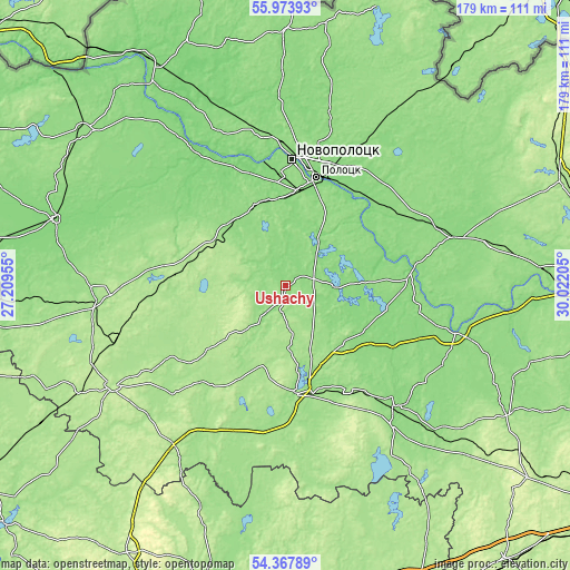
| \ | Map #1 | Map #2 | Topo.Map |
| Scale [m] | 128..175 m | 127..179 m | × |
| Scale [ft] | 420..574 ft | 417..587 ft | × |
| Average | 144.3 m = 473 ft | 147.5 m = 484 ft | × |
| Width | 5.58 km = 3.5 mi | 11.16 km = 6.9 mi | 178.6 km = 111 mi |
| Height | 5.58 km = 3.5 mi | 11.16 km = 6.9 mi | 178.6 km = 111 mi |
| ↑Max Latitude | 55.204086° | 55.229155° | 55.97393° |
| Latitude at center | 55.179° | 55.179° | 55.179° |
| ↓Min Latitude | 55.153899° | 55.128782° | 54.36789° |
| ← Min Longitude | 28.571855° | 28.527909° | 27.20955° |
| Longitude center | 28.6158° | 28.6158° | 28.6158° |
| →Max Longitude | 28.659745° | 28.703691° | 30.02205° |
Nearby cities:
Cities around Ushachy sort by population:
• Navapolatsk elevation 131 m
39.2 km,  358°
358°
• Polatsk 129 m
36 km,  17°
17°
• Hlybokaye 159 m
59 km,  265°
265°
• Lyepyel’ 165 m
33.5 km,  170°
170°
• Novolukoml’ 175 m
66.9 km,  149°
149°
• Chashniki 136 m
49.8 km,  135°
135°
• Dokshytsy 204 m
62.8 km,  239°
239°
• Sharkawshchyna 129 m
75.7 km,  286°
286°
• Konstantinovo 176 m
71.3 km, 144°
• Byahoml’ 181 m
61.2 km,  215°
215°
• Dzisna 113 m
50.3 km,  329°
329°
• Mosar 143 m
73.4 km, 273°
Multilingual:
 En español:
Ushachy elevación 148 m.
 En France:
Ushachy élévation 148 m.


Sources and notes:
- [note 1] Map square and city borders are not equal. Map elevation data is calculated only from area inside that square.
- [src 1] Elevation data from geonames database provided with same terms of usage.
- [src 2] The elevation map of Ushachy is generated using elevation data from NASA's 3 arcsec (90m) resolution SRTM data.
- [src 3] Base (background) map © OpenStreetMap contributors tiles are generated by Geofabrik and OpenTopoMap.
Copyright & License:
This Ushachy Elevation Map is licensed under CC BY-SA. You may reuse any part from this page, if you give a proper credit by linking to this URL:
 More info on terms of use page.