Ghanzi elevation
Ghanzi, Botswana elevation is 1144 meters and Ghanzi elevation in feet is 3753 ft above sea level [src 1]. Ghanzi is a seat of a first-order administrative division (feature code) with elevation that is 132 meters (433 ft) bigger than average city elevation in Botswana.
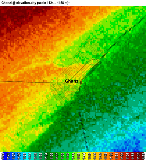
Below is the Elevation map of Ghanzi, which displays elevation range with different colors. Scale of the first map is from 1124 to 1158 m (3688 to 3799 ft) with average elevation of 1141.6 meters (=3745 ft) [note 1]
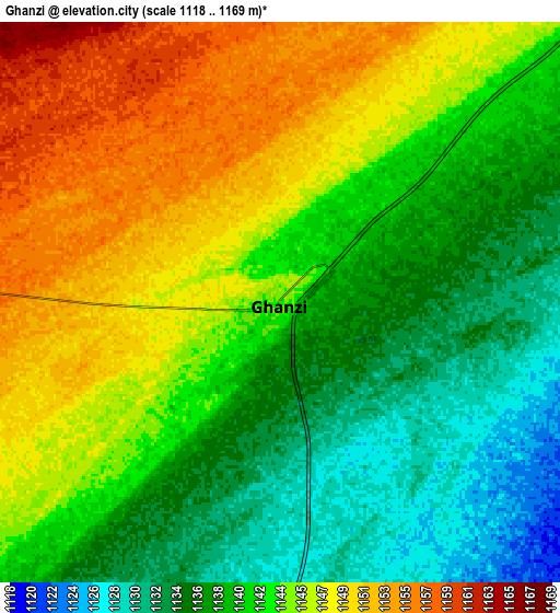
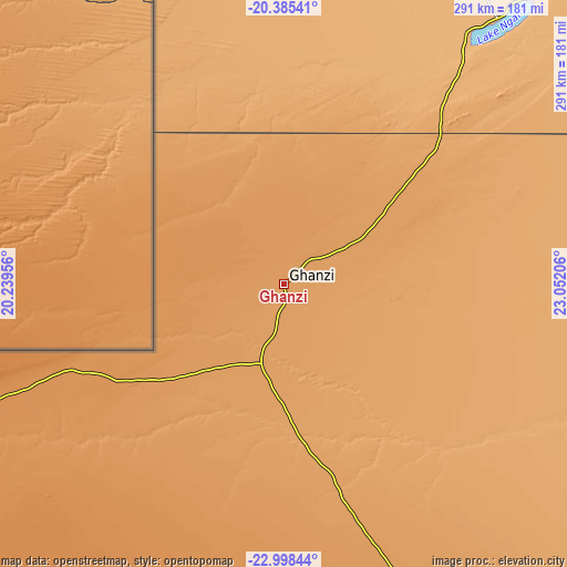
These maps also provides idea of topography and contour of this city, they are displayed at different zoom levels. More info about maps, scale and edge coordinates you can find below images.
| \ | Map #1 | Map #2 | Topo.Map |
| Scale [m] | 1124..1158 m | 1118..1169 m | × |
| Scale [ft] | 3688..3799 ft | 3668..3835 ft | × |
| Average | 1141.6 m = 3745 ft | 1142.1 m = 3747 ft | × |
| Width | 9.08 km = 5.6 mi | 18.16 km = 11.3 mi | 290.5 km = 180.5 mi |
| Height | 9.08 km = 5.6 mi | 18.16 km = 11.3 mi | 290.6 km = 180.6 mi |
| ↑Max Latitude | -21.657013° | -21.616164° | -20.38541° |
| Latitude at center | -21.69785° | -21.69785° | -21.69785° |
| ↓Min Latitude | -21.738676° | -21.77949° | -22.99844° |
| ← Min Longitude | 21.601865° | 21.557919° | 20.23956° |
| Longitude center | 21.64581° | 21.64581° | 21.64581° |
| →Max Longitude | 21.689755° | 21.733701° | 23.05206° |
Nearby cities:
Cities around Ghanzi sort by population:
• Maun elevation 947 m
265 km,  43°
43°
• Rakops 918 m
291 km,  75°
75°
• Hukuntsi 1141 m
256.2 km,  176°
176°
• Kang 1139 m
249.1 km,  151°
151°
• Manyana 1191 m
189.4 km, 177°
• Mopipi 906 m
339.9 km, 80°
• Lehututu 1133 m
253.3 km,  174°
174°
• Nokaneng 957 m
234.9 km,  15°
15°
• Sehithwa 931 m
176.3 km, 39°
• Lokwabe 1120 m
275.2 km, 175°
• Tsau 945 m
191.3 km,  25°
25°
• Dekar 1139 m
34.9 km,  58°
58°
Multilingual:
 En español:
Ghanzi elevación 1144 m.
 En France:
Ghanzi élévation 1144 m.


Sources and notes:
- [note 1] Map square and city borders are not equal. Map elevation data is calculated only from area inside that square.
- [src 1] Elevation data from geonames database provided with same terms of usage.
- [src 2] The elevation map of Ghanzi is generated using elevation data from NASA's 3 arcsec (90m) resolution SRTM data.
- [src 3] Base (background) map © OpenStreetMap contributors tiles are generated by Geofabrik and OpenTopoMap.
Copyright & License:
This Ghanzi Elevation Map is licensed under CC BY-SA. You may reuse any part from this page, if you give a proper credit by linking to this URL:
 More info on terms of use page.